

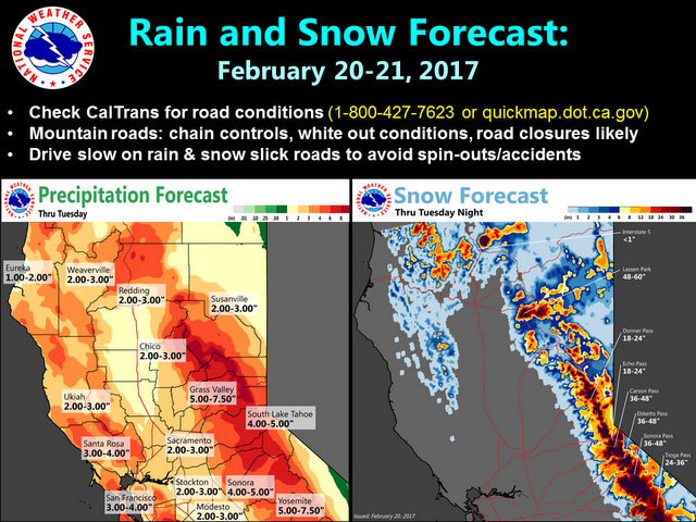
Arnold, CA…Check out the expected rain and snow totals through tomorrow. Heavy snow is expected at pass level with snow levels falling below ~5,000 ft overnight. Be aware of hazardous mountain travel conditions as well as any flooding concerns in your area. The highest snow totals from this storm wave are for our area. Carson, Ebbetts and Sonora Pass areas are forecast to receive 36 to 48 inches of snow above snow level.
Winter Storm Warning
URGENT – WINTER WEATHER MESSAGE
National Weather Service Sacramento CA
123 PM PST Mon Feb 20 2017
…Another strong storm hits northern California through
Tuesday…
.A stronger weather system will move through northern California
through Tuesday. It will bring periods of strong winds and heavy
snow to the higher elevations. A period of higher snow levels
today will limit snow impacts to near passes and higher but snow
levels will fall again by Tuesday morning. If traveling through
the Sierra Cascade range expect chain controls, long delays and
possible closures. Mudslides and rockslides could impact mountain
roads making them impassable for a day or more.
CAZ068-069-220000-
/O.CON.KSTO.WS.W.0010.000000T0000Z-170222T0600Z/
Western Plumas County/Lassen Park-
West Slope Northern Sierra Nevada-
Including the cities of Chester, Quincy, and Blue Canyon
123 PM PST Mon Feb 20 2017
…WINTER STORM WARNING REMAINS IN EFFECT UNTIL 10 PM PST
TUESDAY…
* Main impacts: travelers may experience long delays. Chain
controls likely. Poor visibility due to snow and strong
southwest wind gusts over 60 mph will make travel hazardous.
Mudslides also possible across steeper terrain.
* Confidence…High.
* Locations…Interstate 80 over Donner pass, Highway 50 over
Echo summit, Highway 88 over Carson pass, and Lassen park.
* Timing…periods of heavy snow through Tuesday evening before
dropping off to lighter snow Tuesday night.
* Snow amounts…up to a foot of snow expected down to about
5500 feet with 2 to 5 feet of snow possible above 6000 feet
between today and Tuesday evening.
* Snow levels…snow levels around 7000 feet dropping on Tuesday
to between 4000 and 5000 feet.
A Winter Storm Warning for heavy snow means severe winter weather
conditions are expected or occurring. Significant amounts of
snow are forecast that will make travel dangerous. Only travel in
an emergency. If you must travel, keep an extra flashlight, food,
and water in your vehicle in case of an emergency. Strong winds
are also possible. This will make travel very hazardous or
impossible.
&&
Interact with us via social media www.facebook.com/nws.sacramento
www.twitter.com/nwssacramento
$$
Heavy Rain & Snow Ahead With 3 to 4 Feet Of Snow Forecast Above 5,000 Ft added by admin on
View all posts by admin →