


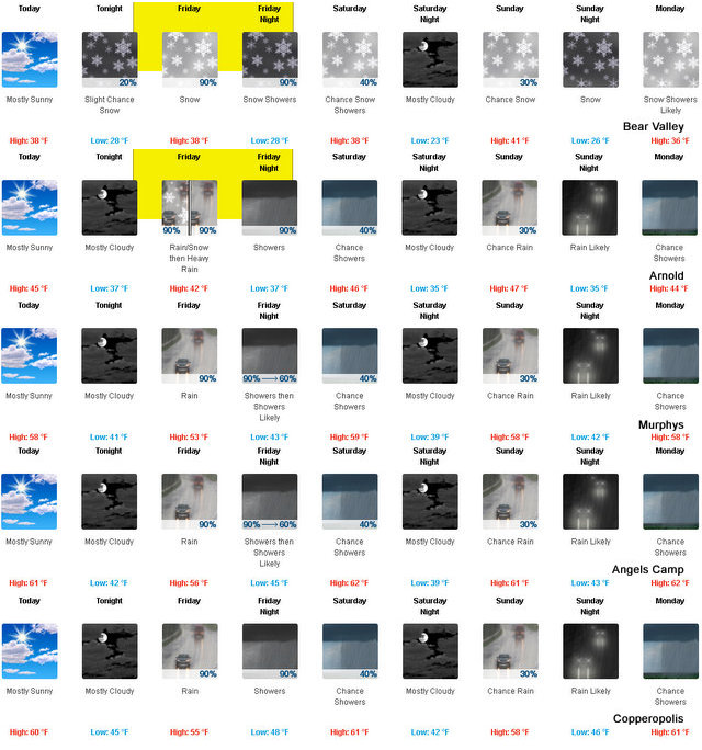
Arnold, CA…A Pacific frontal system is forecast to move through northern California late tonight and Friday. This moderately cool system will bring snowfall down to the Sierra passes and will likely impact travel Friday through Saturday morning. In addition to the snowfall, gusty winds are likely at times especially on Friday. If planning travel through the Sierra Cascade range tonight through early Saturday, expect delays and chain controls. Today: Mostly sunny. Not as cool. Highs 31 to 46 higher elevations…46 to 54 lower elevations. Prevailing northeast winds up to 10 mph shifting to the southwest in the afternoon. Tonight: Mostly cloudy. At lower elevations, a slight chance of rain in the evening, then a chance of rain after midnight. At higher elevations, a slight chance of snow in the evening, then a slight chance of rain and snow after midnight. Lows 24 to 39 higher elevations…36 to 42 lower elevations. Snow level 6000 feet. Prevailing south winds up to 10 mph. Over ridges, prevailing southwest winds 10 to 20 mph increasing to 15 to 30 mph after midnight.
Friday
At lower elevations, rain and heavy snow in the morning, then heavy rain in the afternoon. At higher elevations, rain and snow likely in the morning, then snow and heavy rain in the afternoon. Highs 30 to 44 higher elevations…41 to 51 lower elevations. No snow accumulation lower elevations…1 to 7 inches higher elevations. Snow level 5000 feet increasing to 6500 feet in the afternoon. Prevailing south winds 10 to 20 mph…except southwest 20 to 35 mph with gusts to around 50 mph over ridges.
Friday Night
Rain and snow showers. Lows 24 to 39 higher elevations…38 to 44 lower elevations. No snow accumulation lower elevations…3 to 5 inches higher elevations. Snow level 6500 feet. Prevailing south winds up to 15 mph.
Saturday
Mostly cloudy with a chance of rain and snow showers. Highs 31 to 46 higher elevations…44 to 54 lower elevations. No snow accumulation lower elevations…up to 2 inches higher elevations. Snow level 6000 feet. Prevailing southwest winds up to 10 mph.
Saturday Night
Mostly cloudy. Colder. Lows 24 to 39.
Sunday
Mostly cloudy with a chance of rain and snow. Highs 36 to 51.
Sunday Night
Rain and snow likely. Light snow accumulations possible. Lows 26 to 41.
Monday
Rain and snow showers likely. Light snow accumulations possible. Highs 34 to 49.
Monday Night
Partly cloudy with a slight chance of rain and snow showers. Lows 24 to 39.
Tuesday And Tuesday Night
Partly cloudy. Highs 38 to 53. Lows 26 to 41.
Wednesday
Mostly sunny. Not as cool. Highs 41 to 56.
Winter Storm Watch
URGENT – WINTER WEATHER MESSAGE
National Weather Service Sacramento CA
403 AM PDT Thu Mar 23 2017
…Another round of snow for the Sierra passes…
.A Pacific frontal system is forecast to move through northern
California late tonight and Friday. This moderately cool system
will bring snowfall down to the Sierra passes and will likely
impact travel Friday through Saturday morning. In addition to the
snowfall, gusty winds are likely at times especially on Friday. If
planning travel through the Sierra Cascade range tonight through
early Saturday, expect delays and chain controls. Be prepared and
check the latest weather and road reports before departure.
CAZ069-240045-
/O.NEW.KSTO.WS.A.0011.170324T1200Z-170325T1200Z/
West Slope Northern Sierra Nevada-
Including the city of Blue Canyon
403 AM PDT Thu Mar 23 2017
…WINTER STORM WATCH IN EFFECT FROM LATE TONIGHT THROUGH LATE
FRIDAY NIGHT ABOVE 6000 FEET…
* TIMING…Snowfall begining late tonight and lasting through
Saturday morning.
* SNOW AMOUNTS…8 TO 13 INCHES ABOVE 6000 FEET.
* MAIN IMPACT…HEAVY SNOW OVER THE PASSES WITH TRAVEL DELAYS AND
CHAIN CONTROLS EXPECTED.
* OTHER IMPACTS…Gusty winds up to 45 mph highest elevations
causing white-out conditions at times.
PRECAUTIONARY/PREPAREDNESS ACTIONS…
A Winter Storm Watch means there is a potential for significant
snow accumulations that may impact travel. Continue to monitor
the latest forecasts.
&&
$$
More “Springlike” Weather Ahead For Weekend. Head To The Hills For Great Snow Conditions! added by admin on
View all posts by admin →