

Arnold, CA…Along the West Slope Northern Sierra Nevada Today Rain and snow showers. A weather system will continue to bring more snow to the Sierra Nevada and Southern Cascades through early this evening. The brunt of the snow is expected through the early morning hours. Locally heavy snow with lowering snow levels is possible in showers through the rest of the day. Highs 27 to 41 higher elevations…40 to 48 lower elevations. No snow accumulation lower elevations…1 to 6 inches higher elevations. Snow level 5000 feet. Prevailing southwest winds 5 to 15 mph with gusts to around 30 mph.
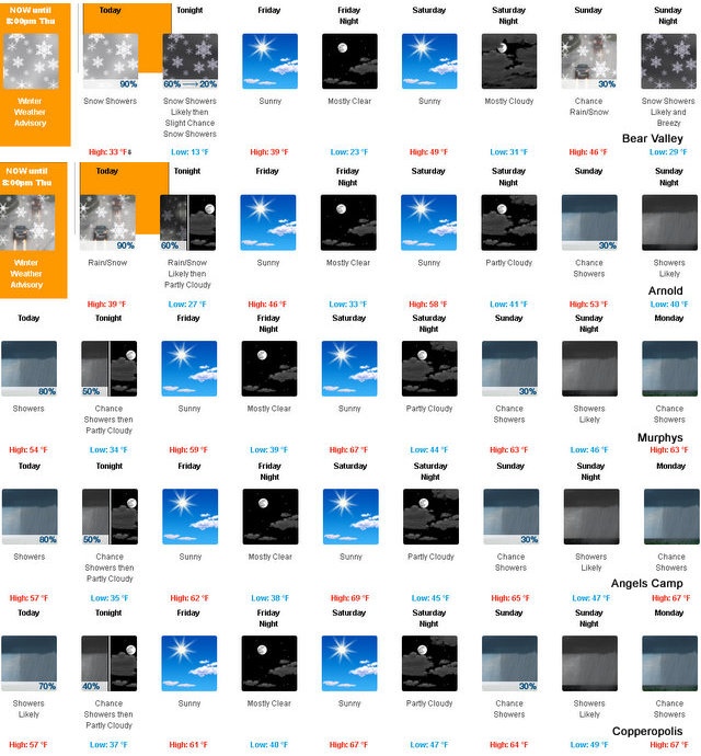
Tonight Mostly cloudy. Rain and snow showers likely in the evening, then a slight chance of rain and snow showers after midnight. Colder. Lows 12 to 27 higher elevations…27 to 35 lower elevations. Little or no snow accumulation lower elevations…1 to 2 inches higher elevations. Snow level 5000 feet decreasing to 4000 feet after midnight. Prevailing south winds up to 15 mph with gusts to around 30 mph.
Friday Mostly sunny. Not as cool. Highs 32 to 47 higher elevations…45 to 55 lower elevations. Prevailing east winds up to 10 mph shifting to the west in the afternoon.
Friday Night Mostly clear. Lows 19 to 34 higher elevations… 31 to 41 lower elevations. Prevailing west winds up to 10 mph shifting to the east after midnight.
Saturday Mostly sunny. Not as cool. Highs 42 to 57 higher elevations…55 to 65 lower elevations. Prevailing east winds up to 10 mph shifting to the southwest in the afternoon.
Saturday Night Mostly cloudy. Lows 29 to 44.
Sunday Mostly cloudy with a chance of rain and snow showers. Highs 42 to 57.
Sunday Night Rain and snow showers likely. Light snow accumulations possible. Lows 29 to 44.
Monday Mostly cloudy with a chance of rain and snow showers. Highs 41 to 56.
Monday Night Rain and snow likely. Light snow accumulations possible. Lows 29 to 44.
Tuesday And Tuesday Night Mostly cloudy with a chance of rain and snow. Highs 41 to 56. Lows 28 to 43.
Wednesday Partly cloudy with a chance of rain and snow. Highs 41 to 56.
Winter Weather Advisory
URGENT – WINTER WEATHER MESSAGE
National Weather Service Sacramento CA
352 AM PDT Thu Apr 13 2017
…More snow for the Sierra and Southern Cascades…
.A weather system will continue to bring more snow to the Sierra
Nevada and Southern Cascades through early this evening. The
brunt of the snow is expected through the early morning hours.
Locally heavy snow with lowering snow levels is possible in
showers through the rest of the day.
Even though the calendar says April, be prepared for wintry
weather conditions over the Sierra through today. Carry chains
and expect travel delays.
CAZ068-069-140300-
/O.CON.KSTO.WW.Y.0015.000000T0000Z-170414T0300Z/
Western Plumas County/Lassen Park-
West Slope Northern Sierra Nevada-
Including the cities of Chester, Quincy, and Blue Canyon
352 AM PDT Thu Apr 13 2017
…WINTER WEATHER ADVISORY REMAINS IN EFFECT UNTIL 8 PM PDT THIS
EVENING…
* TIMING…Heavy snow before sunrise as a cold front passes
through area and then again this afternoon with convection and
lower snow levels.
* MAIN IMPACT…Travel delays, slippery, snow covered roads and
chain controls. Limited visibility with intense snow showers,
especially this afternoon.
* LOCATIONS…Trans-Sierra Highways.
* SNOW AMOUNTS…An additional 1 to 3 inches above 5500 feet this
morning with an additional 4 to 6 inches expected above 4000 to
4500 feet today into early evening.
PRECAUTIONARY/PREPAREDNESS ACTIONS…
A Winter Weather Advisory for snow means that periods of snow
will cause primarily travel difficulties. Be prepared for snow
covered roads and limited visibilities, and use caution while
driving.
&&
$$
Yes, The Sun Will Shine Tomorrow, Winter Storm Warning Until This Evening added by admin on
View all posts by admin →