

Wawona, CA…Crews made significant progress yesterday building and strengthening line on the west side of the fire above Wawona. Contingency lines were also established to the northwest leading to Turner Ridge. Firefighters now have access to the South Fork and have been inserted to extinguish spot fires that have been occurring the past few days. Today crews will continue burning operations above Wawona from the fireline to the S. Fork of the Merced. Mandatory evacuations will remain in place in Wawona for the area east of Highway 41 on Forest Dr. and Chilnualna Falls Rd. until further notice.

Finding insurance is a huge problem for homeowners in the Sierra Nevada foothills. Delos is here to help you find insurance for your new home, a lower price for your current home, or help you out of a non-renewal situation. Delos is an independent insurance brokerage that focuses specifically on wildfire and brush areas. We can write any type of insurance: home, auto, umbrella, business and more. Submit a request for a quote through our website, email, or call. Tom Pratt 209-206-3390 tom@getdelos.com www.getdelos.com Article Continues Below
The fire remains active on the west and south edges. Crews continue to spike in an effort to utilize as much daylight as possible. A combination of firing operations, air support, and direct line construction will continue. Aircraft will assist ground crews when conditions allow generally beginning mid-day.
Strategic objectives remain the same: continue suppression efforts by utilizing air and ground resources to hold the western and southern flanks while monitoring the northern and eastern edges. Minimal Impact Suppression Tactics are being used in the Yosemite Wilderness to manage the area of the fire, using natural barriers such as rocks or streams, trails, and other minimal disturbance methods to contain the fire.
Thunderstorm activity is expected to cause erratic winds over the fire area through mid-week. Gusty winds associated with thunderstorms could cause problematic fire activity near the fire if they materialize.
There are currently 758 personnel assigned to the fire: 22 hand crews, 7 helicopters, 20 engines.
For additional information:
Rapid Notify is a community alert system for rapid event notifications. Register by visiting http://www.rapidnotify.com/customer/Yosemite.html or https://alert.rapidnotify.com/.
Nixle is a public-safety notification system. Sign up for emergency alerts by texting 95389 to 888-777 or visit their website at www.nixle.com
Fire Information: Yose_Fire_Info@nps.gov
Yosemite National Park Fire Information website: http://www.nps.gov/yose/blogs/fireinfo.htm
Facebook, search: Yosemite Fire and Aviation
Twitter, search @YosemiteFire : http://www.twitter.com/YosemiteFire
Air Quality: https://www.nps.gov/yose/learn/nature/aqmonitoring.htm or Current PM2.5 conditions
Basic Information
Current as of 8/22/2017, 7:16:17 AM
Incident Type Wildfire
Cause Unknown
Date of Origin Sunday August 13th, 2017 approx. 02:30 AM
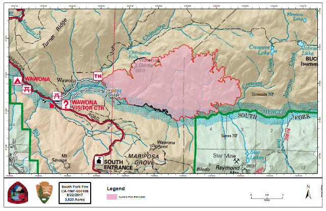
Location .75 mile east of the community of Wawona
Incident Commander Deron Mills
Incident Description Supression
Current Situation
Total Personnel 765
Size 3,820 Acres
Percent of Perimeter Contained 17%
Estimated Containment Date Sunday September 03rd, 2017 approx. 12:00 AM
Fuels Involved
Timber (Litter and Understory) Brush (2 feet)
Significant Events
Moderate, backing, creeping
Outlook
Planned Actions
Holding operation and line construction continue on the west flank of the fire. Spot fires in Division X now have access and suppression activity will be expedited. Strengthening of contingency lines around the community of Wawona continues. Natural barriers are being utilized as much as possible. Security for area closures and security in evacuated areas.
Projected Incident Activity
12 hours: Mandatory evacuations will remain in place for Wawona. Fire remains active along the western and eastern edges. Crew continue to strengthen lines with firing operations located east of Wawona in Division A. Heavy inversions continue to ground aircraft until late afternoon. When these inversions lift, fire activity increases.
24 hours: Mandatory evacuations will remain in place for Wawona. Fire remains active along the western and eastern edges. Crew continue to strengthen lines with firing operations located east of Wawona in Division A. Heavy inversions continue to ground aircraft until late afternoon. When these inversions lift, fire activity increases.
48 hours: Mandatory evacuations will remain in place for Wawona. Continue to aggressively suppress fire spread toward community of Wawona on the west flank of the fire.
Remarks
Crews are being inserted into the southeast portion of the fire in an effort to halt the eastern spread of the fire.
Thunderstorm activity is expected to cause erratic winds over the fire area through mid-week. Gusty erratic winds associated with thunderstorms could cause problematic fire activity in Division A and the firing operations should they materialize. Crews continue to spike in an effort to utilize as much daylight as possible. The west flank of the fire is approximately 1/4 mile east of Wawona. The fire continues to pose a threat to Wawona, the Mariposa Grove of Giant Sequoias. A combination of firing operations, air support, direct line construction and use of natural barriers are the current tactics being implemented to meet protection objectives.
Current Weather
Weather Concerns
A weak area of low pressure will remain anchored off the Southern California coast through Wednesday and bring a threat of thunderstorms to mainly the Sierra each afternoon and evening. Generally light slope and terrain winds can be expected through the period with little diurnal change in temperatures and humidity. A slightly drier, warmer and more stable air mass will move into the district Thursday and continue through Saturday.
South Fork Fire Update, 3,820 Acres, 17% Contained, Wawona Evacuation Orders Remain in Effect added by News Desk on
View all posts by News Desk →