

Yosemite, CA…There are multiple fires burning in Yosemite National Park’s wilderness. Very little change in temperatures and humidities through the weekend. Slight chance for afternoon/early evening showers and thunderstorms for the next several days. A slight warming trend will begin Sunday.

Finding insurance is a huge problem for homeowners in the Sierra Nevada foothills. Delos is here to help you find insurance for your new home, a lower price for your current home, or help you out of a non-renewal situation. Delos is an independent insurance brokerage that focuses specifically on wildfire and brush areas. We can write any type of insurance: home, auto, umbrella, business and more. Submit a request for a quote through our website, email, or call. Tom Pratt 209-206-3390 tom@getdelos.com www.getdelos.com Article Continues Below
Rattlesnake
Discovered: 9/7/17
Location: Hwy 120/Big Oak Flat Rd. at Foresta Rd.
Size: 15 ac. Cause: RV/ Vehicle fire Containment: 100% Fuels: Grass mixed shrubs
Fire started due to an RV catching fire and spreading north into the vegetation. Fire is burning in the old Big Meadow Burn scar which helped limit its spread. Crews and aircraft were able to attack the fire and hold it to 15 aces. Crews will continue to mop up hot spots and secure lines today.
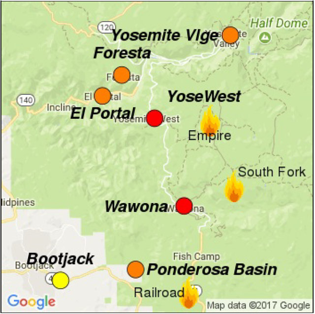
South Fork
Discovered: 8/13/17
Location: .75 miles east of the community of Wawona
Size: 6,640 acres Cause: Unknown Containment: 47% Fuels: Mixed conifer and red fir
Fire remains quiet near the community of Wawona. The most activity yesterday was on the east flank burning into the wilderness through scattered pockets of dense fuel and the south flank backing into the South Fork of the Merced. Very little change in temperatures and humidities through the weekend. Slight chance for afternoon / early evening showers and thunderstorms for the next several days. A slight warming trend will begin Sunday.
The northern spot fire remains south of handline at Turner meadow, crews brought fire down to Chilnualna Creek to secure the spot fire with the main fire. Patrols continue along portions of the fire closest to Wawona. There may be some burning well interior and visible smoke with increased winds due to the storms. Bucket work may be continued on the southern boundary of the fire. Both spot fires south of the South Fork of the Merced drainage were contained and secured with hose lays and handlines. Sections of the north flank and the entire east flank are continuing to burn in the wilderness, and will be monitored by aircraft due to steep and rugged terrain. As fire burns into the high country wilderness it will burn actively through pockets of dense vegetation but will then slow down as it progresses into sparse vegetation and natural granite barriers limiting smoke production. This high country wilderness area has minimal values at risk.
Empire
Discovered: 8/1/17
Location: 1 mile east of Yosemite Ski and Snowboard Area and 3/4 mile south of Glacier Point Road
Size: 5,637 acres Cause: Lightning Containment: 55% Fuels: Red fir
Fire activity was active yesterday. Glacier Point Road is closed. Crews are completing preparing the Glacier Point Road to implement their plan for strategic burning operations that may take place on the GP road to minimize high fire behavior along the road. Very little change in temperatures and humidities through the weekend. Slight chance for afternoon/early evening showers and thunderstorms for the next several days. A slight warming trend will begin Sunday.
Fire crews are implementing a perimeter control strategy for the north, west, and southern flanks of the fire to protect Bridalveil Campground, Yosemite Ski and Snowboard Area, Yosemite West subdivision, Wawona Road (Highway 41), and Glacier Point road. The north end of the fire is in monitor status, the west and south flanks of the fire are contained and holding. Areas of new smoke may be seen as the fire cleans up areas of unburned fuel interior. Fire management personnel are implementing this strategy on three sides of the fire to minimize further smoke production in heavy fuels. The east flank is being allowed to move towards the Illilouette basin to continue to enhance forest resiliency in a fire adapted ecosystem
Yosemite National Park has managed fire in this wilderness area for decades. This high country wilderness area is very steep and rugged with numerous natural barriers and minimal values at risk.
Starr King
Discovered: 8/2/17
Location: N 37° 42.965′ x W 119° 29.588′ at approximately 7800 feet elevation
Size: 58 acres Cause: Lightning Spread Potential: Low/ Moderate
Fuels: Red fir/ Lodgepole Strategy: Monitor
Smoke may be visible from high elevation viewpoints.
Yosemite Creek
Discovered: 8/3/17
Location: N 37° 50.414′ x W 119° 38.088′ at approximately 7,970 feet elevation
Size: 2.4 acres Cause: Lightning Spread Potential: Low
Fuels: Red fir Strategy: Monitor
Porcupine
Discovered: 8/2/17
Location: N 37° 49.336′ x W 119° 34.720′ at approximately 8154 feet elevation off Tioga road near Yosemite Creek Campground road, creeping and smoldering, burning in large logs which are creating smoke.
Size: 4.0 acres Cause: Lightning Spread Potential: Low
Fuels: Lodgepole/Red fir Strategy: Monitor
Knob 91
Discovered: 8/4/17
Location 37° 52.185′ x W 119° 35.217′ at approximately 8980 feet elevation
Size: .39 acres Cause: Lightning Spread Potential: Low
Fuels: Timber litter Strategy: Monitor
No updated maps today.
https://www.wildlandfiresmoke.net/outlooks/2017/CentralSierraFires#Area2
https://app.airsis.com/USFS/UnitMap?custId=11&unitId=1011&isHistoric=False
https://www.nps.gov/yose/learn/nature/aqmonitoring.htm
Yosemite National Park Fire Update September 9th 2017 added by admin on
View all posts by admin →