

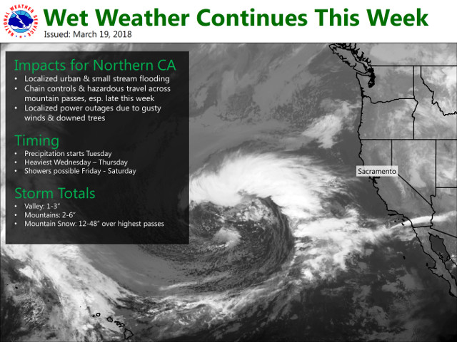
Arnold, CA…Heavy Snow Possible Thursday into Friday. An atmospheric river will be taking aim at the state of California this week. Snow levels will rapidly rise above major pass levels through Wednesday, but will lower again on Thursday as a storm system from the Gulf of Alaska arrives. Heavy snow will be possible above 6500 feet, with the potential for travel delays and chain controls.
Winter Storm Watch
URGENT – WINTER WEATHER MESSAGE
National Weather Service Sacramento CA
237 PM PDT Mon Mar 19 2018
…Heavy Snow Possible Thursday into Friday…
.An atmospheric river will be taking aim at the state of
California this week. Snow levels will rapidly rise above major
pass levels through Wednesday, but will lower again on Thursday
as a storm system from the Gulf of Alaska arrives. Heavy snow will
be possible above 6500 feet, with the potential for travel delays
and chain controls.
CAZ068-069-201300-
/O.NEW.KSTO.WS.A.0009.180322T1800Z-180323T1200Z/
Western Plumas County/Lassen Park-
West Slope Northern Sierra Nevada-
237 PM PDT Mon Mar 19 2018
…WINTER STORM WATCH IN EFFECT FROM THURSDAY MORNING THROUGH
LATE THURSDAY NIGHT ABOVE 6500 FEET…
* WHAT…Heavy snow possible. Plan on difficult travel conditions.
Damage to trees and power lines is possible. Total snow
accumulations of 6 to 12 inches, with localized amounts up to 20
inches, are possible.
* WHERE…Western Plumas County/Lassen Park and West Slope
Northern Sierra Nevada…including Donner Summit over Interstate
80, Echo Summit over US Highway 50, and Carson Pass over State
Route 88.
* WHEN…From Thursday morning through late Thursday night.
* ADDITIONAL DETAILS…Significant reductions in visibility are
possible.
PRECAUTIONARY/PREPAREDNESS ACTIONS…
A Winter Storm Watch means there is potential for significant
snow, sleet or ice accumulations that may impact travel. Continue
to monitor the latest forecasts.
$$
Winter Storm Watch Issued Starting March 22nd added by admin on
View all posts by admin →