


Arnold, CA….From the National Weather Service Sacramento….Wet Weather Returns to Northern California Later this Week. A surge of sub-tropical moisture from Hawaii will bring a return of wet weather to northern California beginning Thursday and continuing into the weekend. Periods of heavy rain, and strong gusty south winds, are possible Friday night and Saturday. Rain should decrease on Sunday.
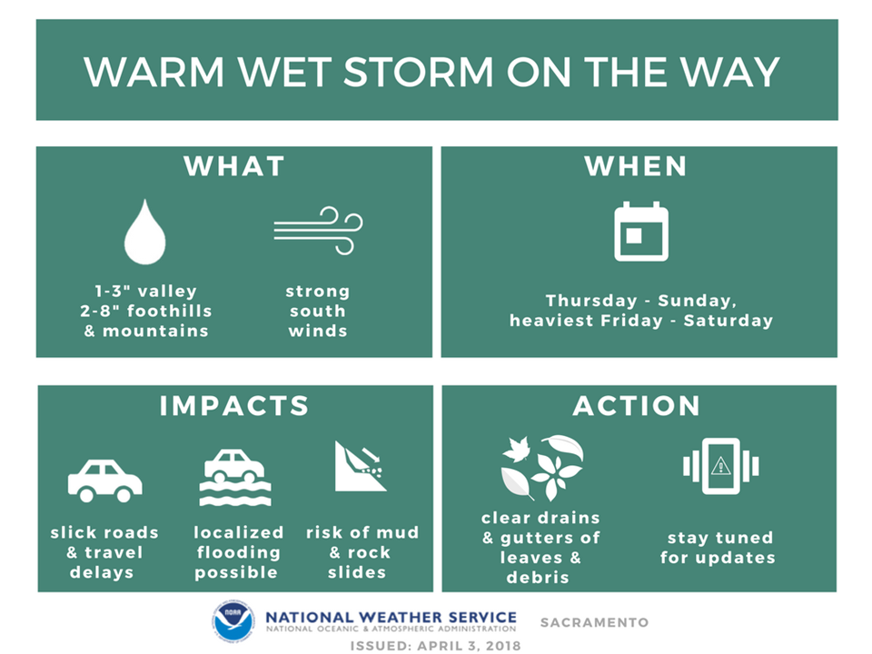
Rainfall amounts from 2 to 7 inches are expected over the mountains, and 1 to 3 inches in the Central Valley. The warm subtropical air will mean high snow levels, generally above the mountain passes until Sunday when the precipitation decreases.
Runoff from this warm storm combined with melting snow over the lower mountainous elevations may cause localized roadway flooding, minor mud and rock slides, or flooding of small river and streams, especially in the Foothills or other low-lying areas.
Stay tuned for updates on this warm, wet storm.
Special Weather Statement
National Weather Service Sacramento CA
201 PM PDT Tue Apr 3 2018
CAZ013>019-063-064-066>069-041915-
Shasta Lake Area / Northern Shasta County-
Burney Basin / Eastern Shasta County-Northern Sacramento Valley-
Central Sacramento Valley-Southern Sacramento Valley-
Carquinez Strait and Delta-Northern San Joaquin Valley-
Mountains Southwestern Shasta County to Northern Lake County-
Clear Lake/Southern Lake County-
Northeast Foothills/Sacramento Valley-Motherlode-
Western Plumas County/Lassen Park-
West Slope Northern Sierra Nevada-
Including the cities of Shasta Dam, Burney, Redding, Red Bluff,
Chico, Oroville, Marysville/Yuba City, Sacramento,
Fairfield/Suisun, Stockton, Modesto, Alder Springs, Lakeport,
Paradise, Grass Valley, Jackson, Chester, Quincy, and Blue Canyon
201 PM PDT Tue Apr 3 2018
…Wet Weather Returns to Northern California Later this Week…
A surge of sub-tropical moisture from Hawaii will bring a return
of wet weather to northern California beginning Thursday and
continuing into the weekend. Periods of heavy rain, and strong
gusty south winds, are possible Friday night and Saturday. Rain
should decrease on Sunday.
Rainfall amounts from 2 to 7 inches are expected over the
mountains, and 1 to 3 inches in the Central Valley. The warm
subtropical air will mean high snow levels, generally above the
mountain passes until Sunday when the precipitation decreases.
Runoff from this warm storm combined with melting snow over the
lower mountainous elevations may cause localized roadway flooding,
minor mud and rock slides, or flooding of small river and
streams, especially in the Foothills or other low-lying areas.
Stay tuned for updates on this warm, wet storm.
$$
Wet Weather Returns to Northern California Later this Week. Inches of Rain in the Forecast! added by admin on
View all posts by admin →