


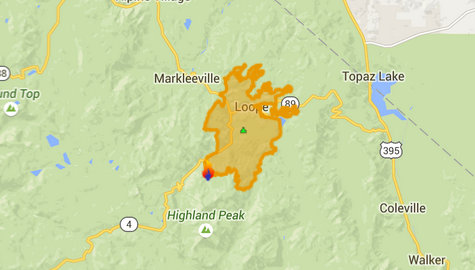
Markleeville, CA…Fire crews continued to increase the percent containment near Markleeville as they mopped up and patrolled the fire perimeter throughout the day. Hotshot crews on the eastern fire edge will continue to construct direct handline in steep and rocky terrain while being supported from the air with water-dropping helicopters. Light precipitation occurred over the northeastern section of the fire yesterday afternoon aiding in suppression activities.
Today’s Activities:Taking advantage of the higher humidity and lower temperatures forecast for today, crews will continue mopping up on the western perimeter and constructing direct hand line on the eastern perimeter. Resource advisors will continue working in the fire area identifying cultural resources affected by the fire.
Road and Area Closures: At 9 a.m. today, State Highway 4 through Markleeville, south over Ebbetts Pass, reopened for through traffic only. Adjacent Forest lands in and near burned are still under forest closure. State Highway 89, starting at the junction with State Highway 4 and continuing over Monitor Pass, will remain closed due to fire activity. Wolf Creek Road will remain closed as well until fire activity diminishes in the area.
Area closures have been issued for the fire area and can be found at http://www.fs.usda.gov/alerts/htnf/alerts-notices and http://www.blm.gov/nv/st/en/fo/carson_city_field.html
The Pacific Crest trail has not been impacted by the Washington Fire and is currently open in all directions.
Basic Information
Current as of 6/28/2015, 10:04:14 AM
Incident Type Wildfire
Cause Lightning/natural
Date of Origin Friday June 19th, 2015 approx. 07:00 PM
Location On CA Highways 4 and 89, 3 miles south of Markleeville, CA
Incident Commander Chris Wilcox
Current Situation
Total Personnel 1,160
Size 17,697 Acres
Percent of Perimeter Contained 37%
Fuels Involved
Timber (Litter and Understory) 2 foot tall brush (sage)
Significant Events
The fire continues to smolder, creeping in some areas and with single-tree torching
Outlook
Planned Actions
Continue to secure line on the west flank between State Highways 4 and 89. Goal is to keep fire from spreading toward Markleeville CA. Continue direct line construction north of Highway 89 to check fire’s northerly spread.
Projected Incident Activity
Minimal. Prediction of increasingly wetter thunderstorms could affect suppression and mop-up operations due to slick roads and flash floods.
Remarks
Fire is burning in hazardous and inaccessible terrain, and has burned into the Carson Iceberg Wilderness.
Current Weather
Weather Concerns
Record high temperatures continue. Scattered thunderstorms occurred today with gusty outflow winds. Red flag warning for thunderstorms and strong outflow winds Sunday. Flash flood potential exists with a possibility of debris flow and rock slides on the burned area.
Fire Update…Washington Fire Reaches 37% Containment & Hwy 4 Now Open added by admin on
View all posts by admin →