Ahwahnee, CA…An unusually heavy inversion stayed over the fire today keeping overall fire activity moderate despite thunderstorm development over the Sierra Crest. The inversion did lift briefly in the late afternoon allowing some columns to build, especially over Sweetwater Ridge and on the Southeastern corner of the fire.
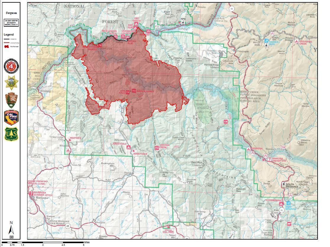
Today, the fire continued to grow north on Ferguson Ridge and toward Highway 140 in the Merced River Canyon, across from the community of El Portal. The fire has remained on the south side of the river. Crews continued structure preparation around residences and businesses today in Yosemite West and Jerseydale. Crews also worked on constructing contingency line southeast of Jerseydale, and along Henness Ridge between Highway 140 and the Wawona Road (the continuation of Highway 41 in Yosemite National Park). That contingency line has been completed to Kirby Peak.
Click Above for Larger Map
Tonight, firefighters will continue to improve containment lines along Sweetwater Ridge and also continue to monitor fire spread in the Merced River Canyon. Fire crews will be taking suppression actions as necessary as the fire approaches Highway 140.
As of 6pm on July 19, 2018, no structures have been damaged or destroyed by the Ferguson Fire.
Yosemite National Park remains open. For information on Yosemite National Park, go to nps.gov/yose or call 209-372-0200.
Incident Start Date: 7/13/2018
Incident Start Time: 9:36 p.m.
Incident Type: Vegetation Fire
Cause: Under Investigation
Incident Location: Merced River Canyon
Unified Command Agencies: CAL FIRE, US Forest Service, Mariposa County Sheriff
Size: 21,541 acres
Containment: 7%
Expected Full Containment: Unknown
Civilian Injuries: 0
Firefighter Injuries: 2
Civilian Fatalities: 0
Firefighter Fatalities: 1
Structures Threatened: 216
Structures Destroyed: 0
Structures Damaged: 0
INCIDENT FACTS
Incident Start Date: 7/13/2018
Incident Start Time: 9:36 p.m.
Incident Type: Vegetation Fire
Cause: Under Investigation
Incident Location: Merced River Canyon
Unified Command Agencies: CAL FIRE, US Forest Service, Mariposa County Sheriff
Size: 21,541 acres
Containment: 7%
Expected Full Containment: Unknown
Civilian Injuries: 0
Firefighter Injuries: 2
Civilian Fatalities: 0
Firefighter Fatalities: 1
Structures Threatened: 216
Structures Destroyed: 0
Structures Damaged: 0
Mandatory Evacuations:
Mandatory Evacuations: Areas that are currently under a mandatory evacuation include:
• Incline Rd from Foresta Bridge to the last BLM campground
• Jerseydale/ Mariposa Pines
• Cedar Lodge/ Indian Flat Campground
• Savage’s Trading Post
• Sweetwater Ridge
• El Portal Trailer Court
Evacuation Advisory:
Evacuation Advisory: This is NOT an Evacuation Order. This is an advisement only of a potential Evacuation Order should conditions change.
• Yosemite West
• Lushmeadows Community
• Ponderosa Basin Community
• Triangle Rd from Jerseydale Rd to Hwy 49 South including all side roads.
• Darrah Rd from Triangle to Sherrod Rd
• East side of Hwy 49S from Darrah Rd to Harris Rd- This includes Boyer Rd, Woodland Area, Wass Rd, Tip Top Rd
• National Park Service El Portal Complex
• Rancheria Flat- Government Housing
• Old El Portal
Evacuation Center(s):
New Life Christian Fellowship: 5089 Cole Rd, Mariposa, CA 95338
Road Closures:
Highway 140 is closed from El Portal Rd. to 1.5 miles West of Midpines. Incline Rd, River Road from Briceburg to the gate at Railroad Flat and all Campground areas along Highway 140 closed. Hites Cove / Jerseydale Rd.
Animal Evac. Center(s):
Small Animal Shelter: SPCA of Mariposa County: 5599 CA-49, Mariposa, CA 95338
Large Animal Shelter:
Mariposa County Fairgrounds: 5007 Fairgrounds Rd, Mariposa, CA 95338
ASSIGNED RESOURCES
Engines: 203
Water Tenders: 39
Helicopters: 16
Hand Crews: 58
Dozers: 41
Total Personnel: 2711
Air Tankers:
Numerous firefighting air tankers are flying fire suppression missions as conditions allow.
Cooperating Agencies: Mariposa County Sheriff’s Office; CAL OES; California Highway Patrol; CALTRANS; California Department of Corrections and Rehabilitation; American Red Cross; National Weather Service; California Conservation Corps; Bureau of Land Management, and additional agencies throughout the state.


