

Awahanee, CA, July 23, 2018 – The Ferguson Fire started July 13 on the Sierra National Forest and is managed under unified command between the United States Forest Service, California Interagency Incident Management Team 4, CALFIRE and the Mariposa County Sheriff’s Office. Much of the fire is burning in steep, rugged terrain with little to no access roads. Mandatory and advisory evacuations are in place in several areas but no homes have been damaged or destroyed.
Click Above for Full Sized Map
The Ferguson Fire is burning in very rough terrain with high firefighter exposure due to very hot conditions and limited access requiring heavy rotor wing support. The fire grew more than 2,500 acres throughout the day and into the night hours Friday. Prior to the Rough Fire, this river canyon held the record for the largest fire on the Sierra NF which burned in 1924.
Secretary of the Interior, Ryan Zinke visited the Ferguson Fire in Mariposa County Saturday….
Yosemite National Park remains open, nps.gov/yose or call 209-372-0200
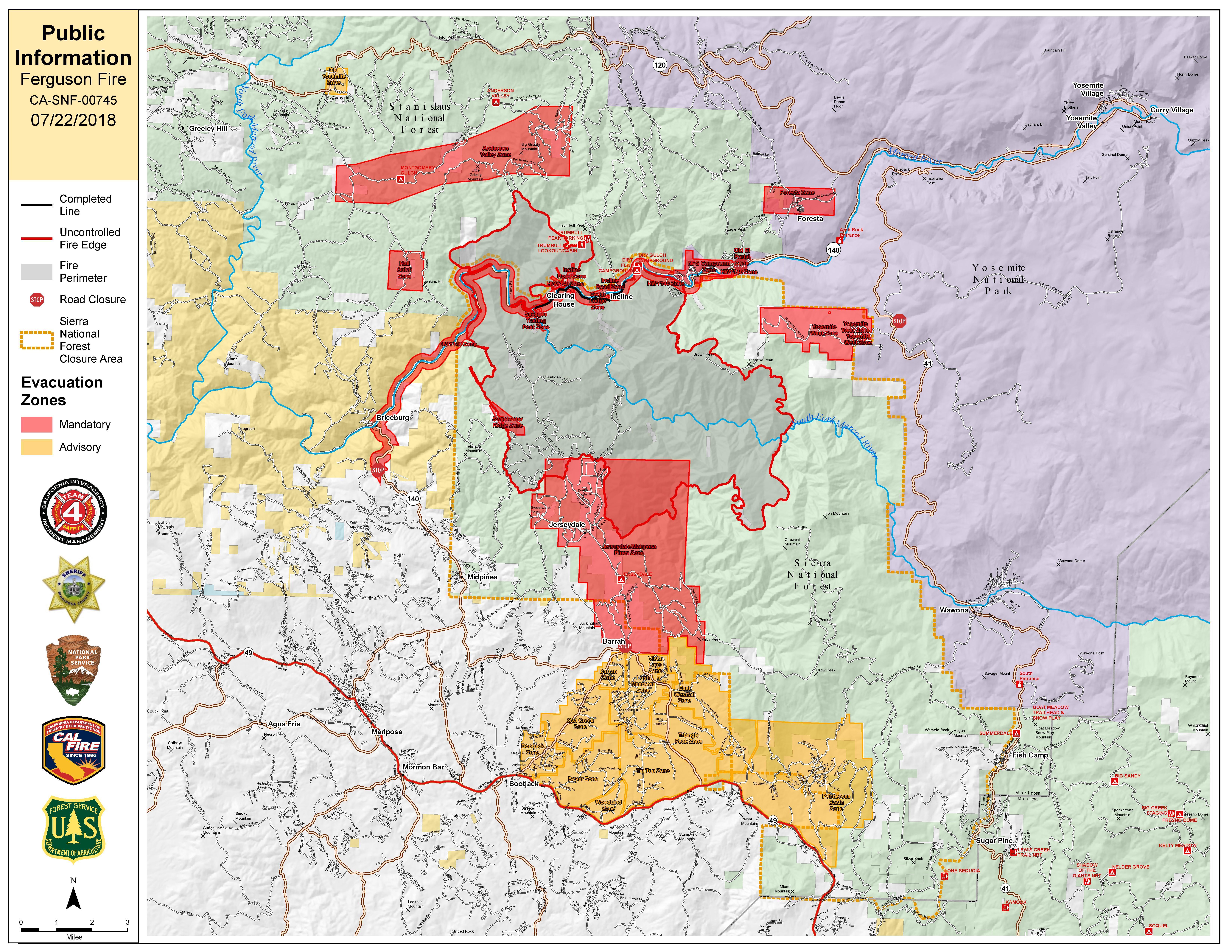
The fire is 33,743 acres with 13% containment. 3,066 personnel are currently engaged on the fire which includes 199 engines, 46 water tenders, 16 helicopters, 66 crews, and 43 dozers. There has been 1 fatality and 6 injuries to date.
Road Closures:
Hwy 140 is closed from 1.9 miles east of Midpines to the Cedar Lodge area MOTORISTS ARE ADVISED TO USE AN ALTERNATE ROUTE
Mandatory Evacuations:
These area are currently under a mandatory evacuation include:
El Portal Trailer Court
Incline Rd from Clearing House to the last BLM campground
Jerseydale/ Mariposa Pines
Cedar Lodge/ Indian Flat Campground
Savage’s Trading Post
Sweetwater Ridge
El Portal Trailer Court
Rancheria Flat – Government Housing
Old El Portal
Yosemite View Lodge
Foresta
Yosemite West
Old Yosemite Road
Evacuation Advisory:
This is NOT an Evacuation Order. This is an advisement only of a potential Evacuation Order should conditions change.
• Lushmeadows Community
• Ponderosa Basin Community
• Triangle Rd from Jerseydale Rd to Hwy 49 South including all side roads.
• Darrah Rd from Triangle to Sherrod Rd
• East side of Hwy 49S from Darrah Rd to Harris Rd- This includes Boyer Rd, Woodland Area, Wass Rd, Tip Top Rd
Evacuation Center:
New Life Christian Fellowship, 5089 Cole Rd, Mariposa, CA 95338
Firefighters Make Progress on Ferguson Fire now 33,743 Acres & 13% Containment! 199 Engines, 46 Water Tenders, 16 Helicopters, 66 Hand Crews, 43 Dozers, & 3,033 Total Personnel added by admin on
View all posts by admin →