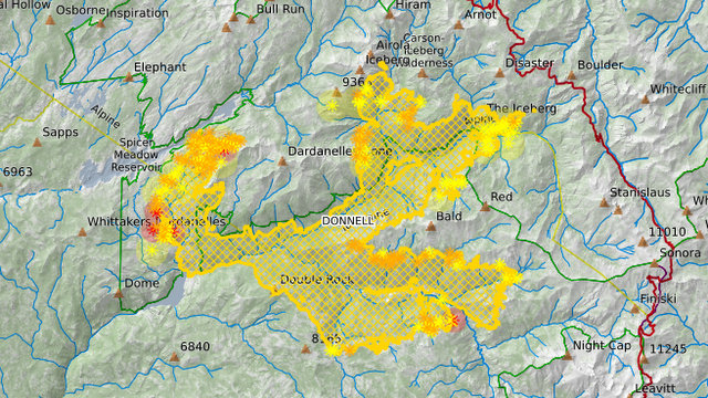
Pinecrest, CA…Wildland Fire Modules made significant progress on the west side of the fire in the Carson-Iceberg Wilderness. Helicopters were able to support the modules by dropping water on the fire throughout the day. In addition, Helirappellers were inserted to construct a helicopter landing area (helispot) west of the fire boundary. On the southern and eastern flanks of the fire, crews continued to mop up and enhance containment lines. Afternoon thunderstorms on the eastern third of the fire forced firefighters to suspend operations early in the day. Night crews will focus on structure protection and mop up on the south eastern side of the fire. Crews in the Carson-Iceberg Wilderness will continue operations tomorrow morning when they can safely navigate the terrain reducing the likelihood of accidents or injuries.

RECREATION RESIDENCE AND FACILITY UPDATE: Initial fire assessments have been completed for all recreation residence tracts along the108 corridor. All permittees have been contacted regarding the condition of their cabin/resort. The main store and lodge of the Dardanelle Resort, 14 of 16 cabins in the Wagner Tract, 36 of 57 cabins in the Brightman Tract, 2 of 2 cabins in the Buena Vista Tract, and 1 of 10 cabins in the Bone Springs Tract were destroyed by the fire. No structures have been reported lost at Baker Station or within Riverside, Cedar Grove, Deadman, Baker, East Douglas, West Douglas, and Twin Buttes Tracts. Firefighters continue to patrol and protect structures within the fire perimeter. Active fire and hazard trees are still present and a potential threat.
Forest Closures: The area includes the Carson-Iceberg Wilderness on the Summit and Calaveras Ranger Districts as well as Spicer Reservoir. Campgrounds are open, but the lake is closed to visitor use. Highway 108 is still closed at Eagle Meadow Road from the west and at the top of Sonora Pass on the east side. The Alpine County Sheriff’s Office has closed the gate at the junction of Highway 4 and Highlands Lake Road (Forest Service Road 8N01). The Pacific Crest Trail has also been closed between Highway 108 and Highway 4 for public safety.
Mandatory Evacuations: Still in effect along Highway 108 from Eagle Meadow Road to Kennedy Meadows (all residences and campgrounds) as well as all along Eagle Meadow Road (5N01) and the Clark Fork Road area. No new mandatory evacuations have been ordered.
Advisory Evacuation: Mill Creek area was put into effect on August 8th.
For more information about the Stanislaus National Forest, visit us at www.fs.usda.gov/stanislaus, “like” us on
Facebook at www.facebook.com/StanislausNF, or “follow” us on Twitter at www.twitter.com/Stanislaus_NF.
For more information on the fire please go to https://inciweb.nwcg.gov/incident/6092/
Fire Information Line: (209) 536-5388 donnellfirestf1918@gmail.com
Fire Resources include: 18 Hand Crews, 5 Helicopters, 48 Engines, 5 Dozers, 8 Water Tenders
LOCATION: Stanislaus National Forest DATE STARTED: August 1, 2018
ACRES: 29,715 PERCENT CONTAINED: 27%
STRUCTURES THREATENED: 220 STRUCTURES DESTROYED: 54
INJURIES/ACCIDENTS: 0 MINOR STRUCTURES DESTROYED: 81
TOTAL PERSONNEL: 934


