

Sacramento, CA…A Red Flag Warning is in effect for much of NorCal. Strong winds & dry conditions will create extreme fire weather conditions. Please be cautious & practice fire safety!Red Flag Warning URGENT – FIRE WEATHER MESSAGE. National Weather Service Sacramento CA. 533 AM PST Thu Nov 8 2018…Critical Fire Weather Conditions through Friday Morning for Portions of Interior Northern California…
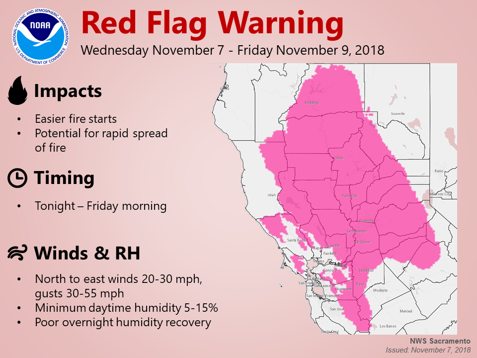
.High pressure building inland has resulted in gusty north to
east wind and drying over northern California today. The
combination of dry fuels, strong wind, and low humidity will lead
to critical fire weather conditions into early Friday. The
strong winds will begin to decreasing Friday morning but dry
conditions will continue through the weekend.
CAZ213>221-263-264-266>269-279-090015-
/O.CON.KSTO.FW.W.0013.000000T0000Z-181109T1500Z/
Eastern Portion of Shasta/Trinity NF-
Burney Basin and Northeast Plateau in Shasta County Including
Northwest Lassen NF north of Lassen NP-
Northern Sacramento Valley to Southern Tehama County Line Below
1000 Ft-
Central Sacramento Valley in Glenn, Colusa, Yuba, Northern
Sutter, and Butte County Below 1000 Ft-
Southern Sacramento Valley in Yolo-
Sacramento Far Western Placer, southern Sutter and Solano County
Below 1000 Ft-Carquinez Strait and Delta-
Northern San Joaquin Valley in San Joaquin and Stanislaus
Counties Below 1000 ft-
Southern Motherlode From 1000 to 3000 Ft. Includes portions of
Calaveras-Tuolumne Unit-Stanislaus NF West of the Sierra Crest-
Southeast Edge Shasta-Trinity NF and Western Portions of Tehama-
Glenn Unit-Lake County Portion of Lake-Napa-Sonoma Unit-
Northern Sierra Foothills from 1000 to 3000 Ft. Includes portions
of Shasta-Trinity and Butte Units-
Northern Motherlode From 1000 to 3000 Ft. Includes portions of
Nevada-Yuba-Placer-Amador and ElDorado Units-
Northern Sierra Including Lassen NP and Plumas and Lassen NF/S
West of the Sierra Crest (West of Evans Peak-Grizzly Peak-
Beckworth Peak)-
Northern Sierra Including the Tahoe and ElDorado NF/S West of the
Sierra Crest-Eastern Mendocino NF-
533 AM PST Thu Nov 8 2018
…RED FLAG WARNING REMAINS IN EFFECT UNTIL 7 AM PST FRIDAY FOR
INTERIOR NORTHERN CALIFORNIA FOR STRONG NORTH TO EAST WINDS AND
LOW HUMIDITY…
* AFFECTED AREA…The Sacramento Valley, the northern Coastal
Range, the west slopes of the northern Sierra Nevada and
adjacent foothills, and much of Shasta County.
* WIND…North to east wind 15 to 25 mph with local gusts 45
mph;local gusts up to 60 mph over exposed ridges. Wind strongest
over ridges and through favorably oriented canyons.
* HUMIDITY…Widespread poor overnight humidity recoveries as
low as 15 to 30 percent. Afternoon humidity may drop as low
as 10 to 15 percent, locally lower.
* IMPACTS…any fires that develop will likely spread rapidly.
Outdoor burning is not recommended.
PRECAUTIONARY/PREPAREDNESS ACTIONS…
A Red Flag Warning means that critical fire weather conditions
are either occurring now, or will shortly. A combination of
strong winds, low relative humidity, and warm temperatures can
contribute to extreme fire behavior.
&&
Interact with us via social media
www.facebook.com/nws.sacramento
www.twitter.com/nwssacramento
$$
Red Flag Fire Warning in Effect for Much of Northern California added by admin on
View all posts by admin →