


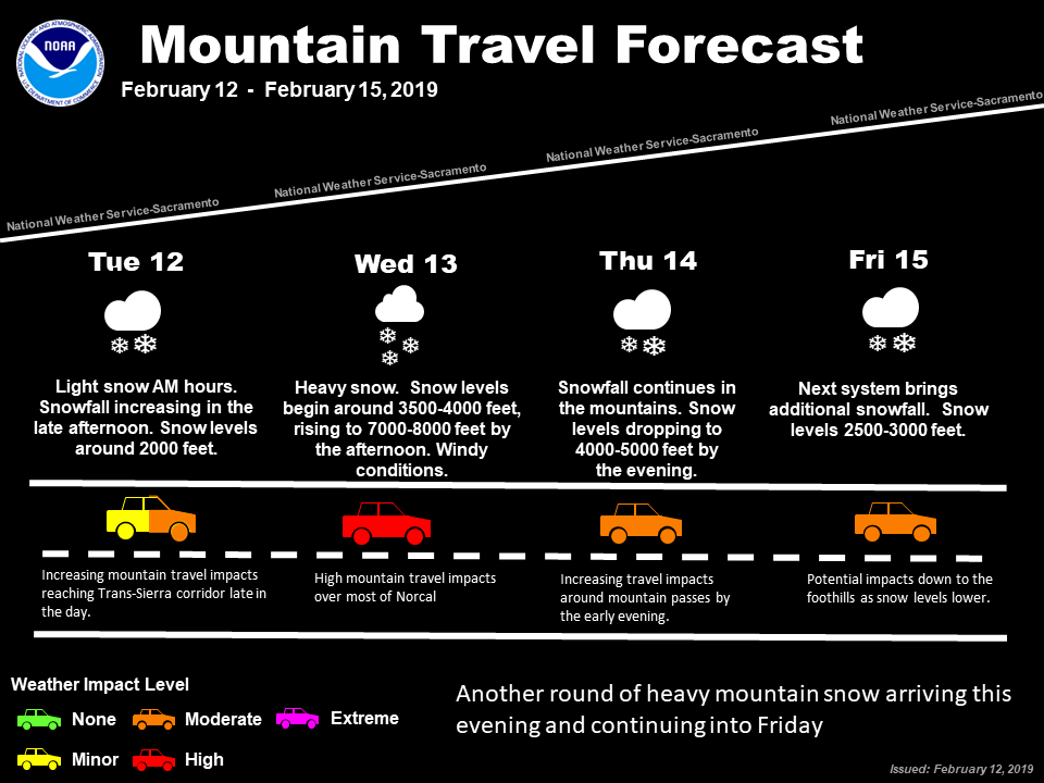
Sacramento, CA…The National Weather Service has issued a Winter Storm Warning for the mountains and a flood warning for lower elevations. An active next several days ahead with snowfall in the forecast through at least Friday. A major winter storm will arrive later today and continue into Thursday. Unlike previous systems, snow levels will rise several thousand feet tomorrow (possibly reaching 7000-8000 feet by the afternoon). Here are the latest thoughts for those traveling to the mountains.
Winter Storm Watch
URGENT – WINTER WEATHER MESSAGE
National Weather Service Sacramento CA
210 AM PST Tue Feb 12 2019
CAZ069-130000-
/O.CON.KSTO.WS.A.0006.190213T0600Z-190215T0000Z/
West Slope Northern Sierra Nevada-
210 AM PST Tue Feb 12 2019
…WINTER STORM WATCH REMAINS IN EFFECT FROM THIS LATE THIS EVENING
THROUGH THURSDAY AFTERNOON ABOVE 4000 FEET…
* WHAT…Heavy snow possible. Travel will be very difficult to
impossible. Damage to trees and power lines is possible. Total
snow accumulations of 1 to 3 feet, with localized amounts up to
5 feet, are possible.
* WHERE…West Slope Northern Sierra Nevada.
* WHEN…From this evening through Thursday afternoon.
* ADDITIONAL DETAILS…Be prepared for chain requirements and
travel delays. Significant reductions in visibility are
possible.
PRECAUTIONARY/PREPAREDNESS ACTIONS…
A Winter Storm Watch means there is potential for significant
snow, sleet or ice accumulations that may impact travel. Continue
to monitor the latest forecasts.
$$
Flood Watch
Flood Watch
National Weather Service Sacramento CA
215 AM PST Tue Feb 12 2019
CAZ013-015>019-063-064-066-067-069-130000-
/O.CON.KSTO.FA.A.0002.190213T1200Z-190215T0000Z/
/00000.0.ER.000000T0000Z.000000T0000Z.000000T0000Z.OO/
Shasta Lake Area / Northern Shasta County-
Northern Sacramento Valley-Central Sacramento Valley-
Southern Sacramento Valley-Carquinez Strait and Delta-
Northern San Joaquin Valley-
Mountains Southwestern Shasta County to Northern Lake County-
Clear Lake/Southern Lake County-
Northeast Foothills/Sacramento Valley-Motherlode-
West Slope Northern Sierra Nevada-
215 AM PST Tue Feb 12 2019
…FLOOD WATCH REMAINS IN EFFECT FROM LATE TONIGHT THROUGH
THURSDAY AFTERNOON…
The Flood Watch continues for
* A portion of northern California…including the following
areas…Carquinez Strait and Delta…Central Sacramento
Valley…Clear Lake/Southern Lake County…Motherlode…
Mountains Southwestern Shasta County to Northern Lake County…
Northeast Foothills/Sacramento Valley…Northern Sacramento
Valley…Northern San Joaquin Valley…Shasta Lake Area /
Northern Shasta County…Southern Sacramento Valley and West
Slope Northern Sierra Nevada.
* From late tonight through Thursday afternoon
* Moderate to heavy rain can be expected during this period.
Storm total rainfall amounts of 1 to 2 inches possible in the
Central Valley, 2 to 4 inches in the foothills and mountains,
and local amounts of 5 to 7 inches across eastern Butte County
and western Plumas County.
* Ponding of water on roadways, rises on small rivers and creeks
are possible.
PRECAUTIONARY/PREPAREDNESS ACTIONS…
A Flood Watch means there is a potential for flooding based on
current forecasts.
You should monitor later forecasts and be alert for possible
Flood Warnings. Those living in areas prone to flooding should be
prepared to take action should flooding develop.
&&
$$
Winter Weather Returns This Evening & Continues Through Feb 15th added by admin on
View all posts by admin →