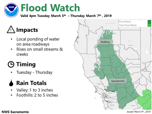
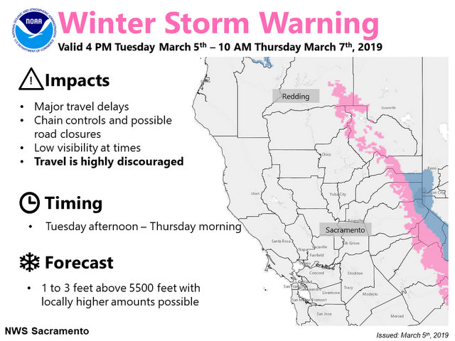
Arnold, CA…Heavy snow and strong wind Tuesday night into Thursday. Pacific storm will bring moderate to heavy snow and strong wind beginning Tuesday afternoon into evening and continuing into Thursday morning. Motorists planning travel into the high country this week should check the latest road and weather conditions, and be prepared for hazardous winter travel. Periods of light to moderate snow showers continue Thursday into Friday as snow levels lower into the foothills. Increased flood potential Tuesday into Thursday…Moderate to heavy rain expected Tuesday night through Wednesday. With streams, creeks, and main stem rivers running at high levels, and already saturated soils, additional rain will increase flooding potential.


Winter Storm Warning
URGENT – WINTER WEATHER MESSAGE
National Weather Service Sacramento CA
125 PM PST Mon Mar 4 2019
…Heavy snow and strong wind Tuesday night into Thursday…
.Pacific storm will bring moderate to heavy snow and strong wind
beginning Tuesday afternoon into evening and continuing into
Thursday morning. Motorists planning travel into the high country
this week should check the latest road and weather conditions,
and be prepared for hazardous winter travel. Periods of light to
moderate snow showers continue Thursday into Friday as snow
levels lower into the foothills.
CAZ069-051230-
/O.UPG.KSTO.WS.A.0009.190306T0100Z-190307T1200Z/
/O.NEW.KSTO.WS.W.0012.190306T0000Z-190307T1800Z/
West Slope Northern Sierra Nevada-
125 PM PST Mon Mar 4 2019
…WINTER STORM WARNING IN EFFECT FROM 4 PM TUESDAY TO 10 AM PST
THURSDAY ABOVE 6000 FEET…
* WHAT…Heavy snow expected. Travel will be very difficult to
impossible. Damage to trees and power lines is possible. Total
snow accumulations of 1 to 4 feet are expected.
* WHERE…West Slope Northern Sierra Nevada including Interstate
80 over Donner Pass and Highway 50 over Echo Summit.
* WHEN…4 PM Tuesday to 10 AM Thursday.
* ADDITIONAL DETAILS…South to southwest wind gusts to 50 mph or
more are possible over higher terrain. Be prepared for
significant reductions in visibility at times.
PRECAUTIONARY/PREPAREDNESS ACTIONS…
A Winter Storm Warning for snow means there will be snow covered
roads and limited visibilities. Travel is not recommended while
the warning is in effect. If you must travel, keep an extra
flashlight, food and water in your vehicle in case of an
emergency.The latest road conditions for the state you are
calling from can be obtained by calling 5 1 1.
$$
Flood Watch
Flood Watch
National Weather Service Sacramento CA
115 PM PST Mon Mar 4 2019
…Increased flood potential Tuesday into Thursday…
.Moderate to heavy rain expected Tuesday night through Wednesday.
With streams, creeks, and main stem rivers running at high
levels, and already saturated soils, additional rain will
increase flooding potential.
CAZ013-015>019-063-064-066-067-051230-
/O.NEW.KSTO.FA.A.0004.190306T0000Z-190307T2000Z/
/00000.0.ER.000000T0000Z.000000T0000Z.000000T0000Z.OO/
Shasta Lake Area / Northern Shasta County-
Northern Sacramento Valley-Central Sacramento Valley-
Southern Sacramento Valley-Carquinez Strait and Delta-
Northern San Joaquin Valley-
Mountains Southwestern Shasta County to Northern Lake County-
Clear Lake/Southern Lake County-
Northeast Foothills/Sacramento Valley-Motherlode-
115 PM PST Mon Mar 4 2019
…FLOOD WATCH IN EFFECT FROM TUESDAY AFTERNOON THROUGH THURSDAY
MORNING…
The National Weather Service in Sacramento has issued a
* Flood Watch for a portion of northern California…including
the following areas…Carquinez Strait and Delta…Central
Sacramento Valley…Clear Lake/Southern Lake County…
Motherlode…Mountains Southwestern Shasta County to Northern
Lake County…Northeast Foothills/Sacramento Valley…Northern
Sacramento Valley…Northern San Joaquin Valley…Shasta Lake
Area / Northern Shasta County and Southern Sacramento Valley.
* From Tuesday afternoon through Thursday morning
* Moderate to heavy rain can be expected Tuesday night through
Wednesday night. 1 to 3 inches of rain is forecast over much of
the Sacramento and Northern San Joaquin Valley, with 2 to 5
inches in the surrounding foothills through early Thursday.
* Recent burn scar areas may also experience minor mud, rock and
debris flows, especially if thunderstorms develop over these
areas on Wednesday. This includes the Mendocino Complex burn
area in Lake, Glenn, Colusa Counties.
PRECAUTIONARY/PREPAREDNESS ACTIONS…
A Flood Watch means there is a potential for flooding based on
current forecasts.
You should monitor later forecasts and be alert for possible
Flood Warnings. Those living in areas prone to flooding should be
prepared to take action should flooding develop.


