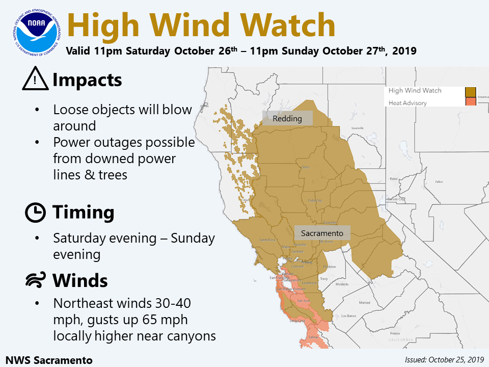
Sacramento, CA…The High Wind Watch has been expanded to include much of interior NorCal. Local gusts over 60 mph are possible. The full watches and warnings are below…

Red Flag Warning
URGENT – FIRE WEATHER MESSAGE
National Weather Service Sacramento CA
1256 PM PDT Fri Oct 25 2019
…A RED FLAG WARNING IN EFFECT FROM 11 AM SATURDAY TO 11 AM PDT
MONDAY…
A strong but dry storm system will move south through northern
California Saturday night and Sunday. This system will cause
strong and potentially damaging North to East winds over much of
interior California including the Delta, portions of the
mountains and foothills. This will likely be the strongest wind
storm of the fall season and one of the strongest of the past few
years. Extreme fire weather conditions are likely.
CAZ214-218>221-267-269-261600-
/O.UPG.KSTO.FW.A.0008.191027T0600Z-191028T1200Z/
/O.NEW.KSTO.FW.W.0009.191027T0600Z-191028T1800Z/
Burney Basin and Northeast Plateau in Shasta County Including
Northwest Lassen NF north of Lassen NP-Carquinez Strait and Delta-
Northern San Joaquin Valley in San Joaquin and Stanislaus
Counties Below 1000 ft-
Southern Motherlode From 1000 to 3000 Ft. Includes portions of
Calaveras-Tuolumne Unit-Stanislaus NF West of the Sierra Crest-
Northern Motherlode From 1000 to 3000 Ft. Includes portions of
Nevada-Yuba-Placer-Amador and ElDorado Units-
Northern Sierra Including the Tahoe and ElDorado NF/S West of the
Sierra Crest-
1256 PM PDT Fri Oct 25 2019
…RED FLAG WARNING IN EFFECT FROM 11 PM SATURDAY TO 11 AM PDT
MONDAY FOR LOW HUMIDITY AND STRONG NORTH TO NORTHEAST WINDS…
The National Weather Service in Sacramento has issued a Red Flag
Warning, which is in effect from 11 PM Saturday to 11 AM PDT
Monday. The Fire Weather Watch is no longer in effect.
* AFFECTED AREA…Fire weather zone 267.Fire weather zone 269.
* WIND…Northeast to east wind 25 to 45 mph with gusts 35 to
65 mph, locally higher in favored canyons and exposed ridges.
* HUMIDITY…Daytime minimum humidities in the teens and single
digits with poor overnight recoveries from the teens to 30
percent.
* IMPACTS…Any fires that develop will likely spread rapidly.
Outdoor burning is not recommended.
PRECAUTIONARY/PREPAREDNESS ACTIONS…
A Red Flag Warning means that critical fire weather conditions
are either occurring now, or will shortly. A combination of
strong winds, low relative humidity, and warm temperatures can
contribute to extreme fire behavior.
&&
Interact with us via social media
www.facebook.com/nws.sacramento
www.twitter.com/nwssacramento
$$
High Wind Watch
URGENT – WEATHER MESSAGE
National Weather Service Sacramento CA
923 AM PDT Fri Oct 25 2019
…HIGH WIND WATCH IN EFFECT FROM SATURDAY EVENING THROUGH SUNDAY
EVENING…
.A dry and windy weather system will move south through northern
California Saturday night and Sunday. Strong, to potentially
damaging, north to east winds will develop across much of the
region. This will likely be the strongest north wind event so far
this season.
CAZ015>018-063-064-066>069-261430-
/O.CON.KSTO.HW.A.0002.191027T0600Z-191028T0600Z/
Northern Sacramento Valley-Central Sacramento Valley-
Southern Sacramento Valley-Carquinez Strait and Delta-
Mountains Southwestern Shasta County to Northern Lake County-
Clear Lake/Southern Lake County-
Northeast Foothills/Sacramento Valley-Motherlode-
Western Plumas County/Lassen Park-
West Slope Northern Sierra Nevada-
Including the cities of Redding, Red Bluff, Chico, Oroville,
Marysville/Yuba City, Sacramento, Fairfield/Suisun,
Alder Springs, Lakeport, Paradise, Grass Valley, Jackson,
Chester, Quincy, and Blue Canyon
923 AM PDT Fri Oct 25 2019
…HIGH WIND WATCH REMAINS IN EFFECT FROM SATURDAY EVENING
THROUGH SUNDAY EVENING…
* WHAT…Northerly wind gusts of 45 to 55 mph in the Sacramento
Valley and Delta with local northeast wind gusts of 55 to 65
mph in the foothills and mountains.
* WHERE…Sacramento Valley and surrounding foothills and
mountains.
* WHEN…From Saturday evening through Sunday evening.
* IMPACTS…Damaging winds could blow down trees and power
lines. Widespread power outages are possible. Difficult
driving conditions.
* ADDITIONAL DETAILS…Trees damaged in previously burned areas
will likely fall with these winds.
PRECAUTIONARY/PREPAREDNESS ACTIONS…
Monitor the latest forecasts and warnings for updates on this
situation. Fasten loose objects or shelter objects in a safe
location prior to the onset of winds.
&&
$$


