

San Andreas, CA…..The Good News is that acreage stayed about the same today. The Bad News is Today the sad numbers started coming in on the number of homes lost. 86 Homes and 51 outbuildings have been lost. Many of these are in the initial wave areas of this fire and also up Jesus Maria. Fire behavior remained very active throughout the night with spotting and torching. Critical fuel moisture levels, steep terrain, and fire access continue to provide challenges for firefighters. Mandatory evacuations continue to expand as the fire continues to grow. ***Damage Assessment teams have arrived and started evaluations of damaged and destroyed structures***
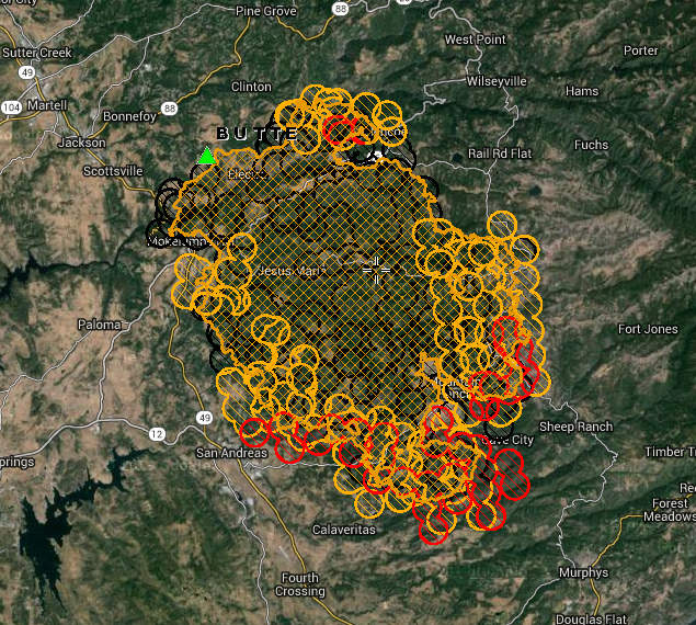
Butte Fire
Butte Fire Incident Information:
Last Updated: September 12, 2015 7:15 pm
Date/Time Started: September 9, 2015 2:26 pm
Administrative Unit: CAL FIRE Amador – El Dorado Unit
County: Amador & Calaveras Counties
Location: Butte Mountain Road, east of Jackson
Acres Burned – Containment: 65,000 acres – 15% contained
Structures Threatened: 6,400
Structures Destroyed: 86 homes, 51 outbuildings
Evacuations: Mandatory Evacuation Orders:
San Andreas at Pope, West Murray Creek, Lewis, Miller, San Andreas Elementary, Goldstrike, Mountain Ranch East to Windmill, Wimbledon Drive, Forest Hill, and Turner Court. Please leave the area immediately.
(Amador County) Canyon View, Fig Tree Lane, and Ponderosa Way; the Town of Pine Grove to include all areas South of Hwy 88 from West Clinton Road, East to Ranch Drive. Inclusive of the Communities of Ranch House Estates, Pine Acres, Jackson Pines, Pine Drove Ranchettes and Lake Tabeau.
(Calaveras County) Town of Mokelumne Hill, East of Hwy 49 from the Amador/Calaveras County line South to Goldstrike Road. South on Goldstrike Road to the Community of San Andreas. Rural areas East of San Andreas to Mountain Ranch Road. Mountain Ranch Road to Calaveritas Road to Fourth Crossing. Fourth Crossing to Hwy 49. East side of Hwy 49 South to North side of Hwy 4 (Angels Camp). North side of Hwy 4 East to Town of Arnold. All of SR 26 from Mokelumne Hill North to the Amador/Calaveras County line. To include the communities of Glencoe, Westpoint, and Wilseyville.
Evacuations Advisories:
(Amador County) Hwy 88 from Ranch Road East to Tiger Creek Road (Red Corral and Buckhorn Areas).
(Calaveras County) City of Angels Camp, Hwy 49 South to Hwy 4 South at the city limits of Angels Camp. Town of Arnold, Northwest of Hwy 4 includes sub-divisions of Lakemont, Mill Woods and Meadowmont. Hwy 4 North to Sheep Ranch Road/Blue Lake Springs sub-division, Big Trees State Park, Town of Dorrington, Town of Murphys and Forest Meadows. Town of San Andreas. Poole Station Road, Carroll Kennedy Road, Cement Plant Road, Demearest Mine Road, Oak Valley Road, Gelding Road, Stallion Road, Deer Creek Road, Copello Road.
Evacuation Centers:
Red Cross: Debbie Calcote 925-588-6678
Jackson Rancheria Hotel, 12222 New York Ranch Road, Jackson, CA
Jenny Lind Veterans Hall, 189 Pine Street, Valley Springs, CA
Good Samaritan Church, 4684 Baldwin Street, Valley Springs, CA
Large Animal Pet Shelters: (Calaveras) Calaveras County Fairgrounds (Amador) Amador County Fairgrounds, contact Kelly Reason at 530-503-5233
Cooperating Agencies: Cal OES, USFS, BLM, PG&E, CHP, Calaveras County Sheriff, Amador County Sheriff, Calaveras PUD, CDCR, Sutter Creek Fire Department, Red Cross, CAL-TRANS, CA State Parks, Amador Fire Protection District.
Total Fire Personnel: 3,852
Total Fire Engines: 452
Total Fire crews: 77
Total Airtankers: 8
Total Helicopters: 17
Total Dozers: 94
Total Water Tenders: 48
Long/Lat: -120.70418, 38.32974
Conditions: Fire behavior remained very active throughout the night with spotting and torching. Critical fuel moisture levels, steep terrain, and fire access continue to provide challenges for firefighters. Mandatory evacuations continue to expand as the fire continues to grow. ***Damage Assessment teams have arrived and started evaluations of damaged and destroyed structures***
Road Closures:
(Amador County) Clinton Road at Butte Mountain Road (Both Ends) Butte Mountain Road Cutoff at Clinton Road. Amador Lane at Clinton Road, Electra at SR 49, Ponderosa Road at Tabeaud, Access to Lake Tabeaud is closed; Hwy 88 at W. Clinton Road, Hwy 88 at Irish Town Road, Hwy 88 at Tabeaud Road, Hwy 88 at Aqueduct Circle, Highway 88 at Mount Zion, SR 26 South of Hwy 88.
(Calaveras County) SR 26 from Mokelumne Hill to Ridge Road; Ridge Road closed to Railroad Flat Road; Railroad Flat Road closed to Mountain Ranch Road; Mountain Ranch Road closed to Hwy 49; Michel Road is closed.
Phone Numbers (530) 647-5218 (Fire Information Line)
Phone Numbers (209) 754-5527 (Fire Information Line)
Butte Fire Evening Update….86 Homes & 51 Outbuildings Destroyed, 65,000 acres with 15% Containment, 3,852 Personnel added by admin on
View all posts by admin →
I would trust and give more credit to your news site if you used real names instead of generic admin references to the stories you post here. Transparency issues at hand. Just want to know the source and attribution for the information. Thanks.
His name is John Hamilton and he has a reputation of integrity like few reporters today and I personally attest to his credibility!
Can you forward me a link of the map you have in this story to my email? Very informative data!
Thank you!