


Bear Valley, CA…Today At lower elevations…heavy rain in the morning…then rain showers…snow showers and a slight chance of thunderstorms in the afternoon. At higher elevations…heavy rain and snow in the morning…then snow showers…rain showers and a slight chance of thunderstorms in the afternoon. Highs 33 to 48 higher elevations…45 to 53 lower elevations. No snow accumulation. Snow level 7500 feet decreasing to 5500 feet in the afternoon. Prevailing northeast winds up to 10 mph shifting to the west in the afternoon. Tonight Mostly cloudy. At lower elevations…rain showers… Snow showers and a slight chance of thunderstorms in the evening…then a chance of rain showers after midnight. At higher elevations…snow showers and a slight chance of thunderstorms in the evening…then a chance of rain and snow showers after midnight. Colder. Lows 18 to 33 higher elevations…30 to 42 lower elevations. No snow accumulation. Snow level 5000 feet. Prevailing northwest winds up to 10 mph shifting to the north after midnight.
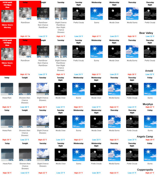
Tuesday
Mostly cloudy. At lower elevations…a slight chance of rain showers. At higher elevations…a slight chance of snow showers in the morning…then a slight chance of rain and snow showers in the afternoon. Highs 31 to 46 higher elevations… 47 to 55 lower elevations. Snow level 5000 feet. Prevailing northeast winds 5 to 15 mph shifting to the north in the afternoon.
Tuesday Night
Partly cloudy. Colder. Lows 15 to 30 higher elevations…27 to 39 lower elevations. Prevailing east winds up to 10 mph.
Wednesday
Mostly sunny. Highs 33 to 48 higher elevations… 48 to 56 lower elevations. Prevailing northeast winds up to 15 mph.
Wednesday Night
Mostly clear. Lows 21 to 36.
Thursday
Mostly sunny. Not as cool. Highs 41 to 56.
Thursday Night
Partly cloudy. Lows 25 to 40.
Friday Through Sunday
Mostly clear. Highs 49 to 64. Lows 27 to 42.
Winter Storm Warning Until 10pm Tonight added by admin on
View all posts by admin →