


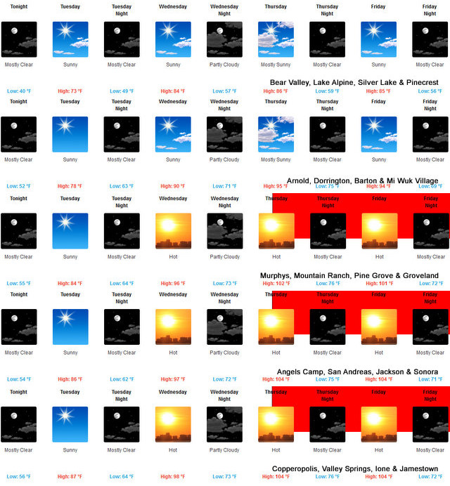
Arnold, CA…The National Weather Service in Sacramento CA has issued an Excessive Heat Warning as…Dangerously hot conditions to return to northern California. High pressure over the Desert Southwest will build west over California later this week, resulting in widespread warming over northern California. High temperatures will soar well into the triple digits by Thursday Valley-wide with some areas in the Sacramento and San Joaquin Valleys approaching 110 to 112 degrees for Thursday and Friday. Isolated areas could get as hot as 113 degrees. These hot afternoon temperatures, combined with warm overnight lows in the upper 60s to low 80s, will produce widespread high to very high heat risk. Consequently, an Excessive Heat Warning has been issued.
CAZ013-015>019-063-066-067-151300-
/O.UPG.KSTO.EH.A.0002.210617T1900Z-210620T0400Z/
/O.NEW.KSTO.EH.W.0002.210617T1800Z-210620T0400Z/
Shasta Lake Area / Northern Shasta County-
Northern Sacramento Valley-Central Sacramento Valley-
Southern Sacramento Valley-Carquinez Strait and Delta-
Northern San Joaquin Valley-
Mountains Southwestern Shasta County to Western Colusa County-
Northeast Foothills/Sacramento Valley-Motherlode-
Including the cities of Shasta Dam, Redding, Red Bluff, Chico,
Oroville, Marysville/Yuba City, Sacramento, Fairfield/Suisun,
Stockton, Modesto, Alder Springs, Paradise, Grass Valley,
and Jackson
203 PM PDT Mon Jun 14 2021
…EXCESSIVE HEAT WARNING IN EFFECT FROM 11 AM THURSDAY TO 9 PM
PDT SATURDAY…
* WHAT…Dangerously hot conditions with afternoon highs around
100 to 112 degrees. Isolated locations may approach 113
degrees on the hottest afternoons in the Sacramento and
northern San Joaquin Valleys.
* WHERE…Sacramento Valley, northern San Joaquin Valley, and
adjacent foothills.
* WHEN…From 11 AM Thursday to 9 PM PDT Saturday.
* IMPACTS…Widespread high to very high heat risk with near-
record and possibly record-breaking heat. Extreme heat will
significantly increase the potential for heat-related
illnesses.
* ADDITIONAL DETAILS…Hottest afternoons are forecast to occur on
Thursday and Friday with hot conditions continuing into the
weekend.
PRECAUTIONARY/PREPAREDNESS ACTIONS…
Drink plenty of fluids, stay in an air-conditioned room, stay out
of the sun, and check up on relatives and neighbors. Young
children and pets should never be left unattended in vehicles
under any circumstances.
Take extra precautions if you work or spend time outside. When
possible reschedule strenuous activities to early morning or
evening. Know the signs and symptoms of heat exhaustion and heat
stroke. Wear lightweight and loose fitting clothing when
possible. To reduce risk during outdoor work, the Occupational
Safety and Health Administration recommends scheduling frequent
rest breaks in shaded or air conditioned environments. Anyone
overcome by heat should be moved to a cool and shaded location.
Heat stroke is an emergency! Call 9 1 1.
&&
$$
U.S. Dept. of Commerce
NOAA National Weather Service
1325 East West Highway
Silver Spring, MD 20910
E-mail: w-nws.webmaster@noaa.gov
Page last modified: May 16, 2007
Disclaimer
Credits
Glossary
Privacy Policy
About Us
Career Opportunities
NATIONAL WEATHER SERVICE: for Safety, for Work, for Fun – FOR LIFE
Excessive Heat Warning as Dangerously Hot Conditions to Return to Northern California added by admin on
View all posts by admin →