

Grizzly Flat, CA…Throughout the night there was active fire with short range spotting and rollout was still occurring in steep drainages from fire weakened timber. With historic drought conditions there is heavy dead and down fuels through the fire area. Northern California remains under fuels and fire behavior advisory. Due to ongoing damage assessment of the area the numbers of destroyed and damaged structures are subject to change.
To better provide public and firefighter safety due to extreme fire conditions throughout Northern California, and strained firefighter resources throughout the Country, the USDA Forest Service Pacific Southwest Region is announcing a temporary closure of nine National Forests. This closure will be effective on August 22, 2021, at 11:59 p.m. through September 6, 2021, at 11:59 p.m. The closure order can be found at https://go.usa.gov/xF7EM
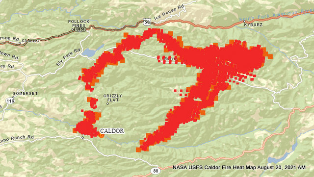
Incident Start Date: August 14, 2021 Incident Start Time: 6:54 P.M. Incident Type: Wildland Fire Cause: Under Investigation Incident Location: 2 miles east of Omo Ranch, 4 miles south of the community of Grizzly Flats CAL FIRE Unit: Amador – El Dorado AEU Unified Command Agencies: CAL FIRE AEU, USDA Forest Service – El Dorado National Forest
Size: 73,415
Containment: 0%
Expected Full Containment: August 31, 2021
First Responder Fatalities: 0
First Responder Injuries: 0
Civilian Fatalities: 0
Civilian Injuries: 2
Structures Threatened: 6,905
Structures Destroyed: 104
Structures Damaged: Undetermined
AMADOR COUNTY -WARNINGS
• Shenandoah Road at the Amador County line west through the River Pines
• community, continuing west on Shenandoah Road to Ostrom Road.
• South on Ostrom Road to Jibboom Street, West on Jibboom Street to Fiddletown
• Road.
• East on Fiddletown Road to Hale Road. South on Hale Road to Shake
• Ridge Road.
• East on Shake Ridge Road to Charleston Road.
• South on Charleston Road to the intersection of Charleston Road and Rams Horn
• Grade.
• Due east to Highway 88 at Tiger Creek Road.
• Tiger Creek Road east to Salt Springs Reservoir Road.
• East on Salt Springs Reservoir Road to the east end of the Salt Springs Reservoir. Due north from the east end of Salt Springs Reservoir to Highway 88.
EL DORADO COUNTY – ORDERS
• Grizzly Flat: The areas on Grizzly Flats Road east of Kendra Way into Grizzly
• Flats Proper. The areas of Diamond Railroad Grade, Old School House, Sweeney Road, Caldor Road, and steely Ridge.
• Grizzly Flats Road east of four corners in somerset into Grizzly Flats Proper.
• The areas of Myers Lane, Varmet Ridge Road, Rodwell Canyon Road, Snowbird Lane, and Mehwald Lane.
• East of Sly Park Road between Highway 50 and Mormon Emigrant Trail to Ice House Road. This includes the communities of Pacific House and Fresh Pond.
• North of Highway 50, east of Forebay Road to Ice House Road.
• Intersection of Perry Creek and Hawk Haven, the East side of Fairplay Road from Perry Creek South to Cedarville Road. This includes Slug Gulch, Omo Ranch, and all roads off of Slug Gulch and Omo Ranch.
• All roads off of Omo Ranch from Cedarville Road to Hwy 88.
• The area between Highway 88 and Mormon Emigrant Trail
• South of Highway 50 from Snows Road to Ice House Road.
• Between Highway 50 and Slab Creek from Snows Road to Ice House Road.
• South of Highway 50 from Ice House Road to Silver Fork Road. This includes the community of Kyburz.
• North of Highway 50 from Ice House Road to Silver Fork Road to include Ice House Reservoir, Union Valley Reservoir, and Loon Lake.
EL DORADO COUNTY – WARNINGS:
• North of Slab Creek to Wentworth Springs Road between Sand Mountain and Loon Lake.
• Mosquito Road from the bridge North to include the Community of Swansboro.
• North of Highway 50 to Slab Creek between Smith Flat and Snows Road.
• South of Highway 50 to Pleasant Valley between Smith Flat and Snows Road, and North of Pleasant Valley between Holm and Newtown.
• South of Pleasant Valley between Bucks Bar Road and Newtown Road, East of Bucks Bar Road to Mt Aukum Road.
• Southwest of Bucks Bar Road to Ladies Valley Road including the community of Outingdale, Ant Hill Road, Perry Creek Road and Sand Ridge between Ladies Valley Road and Bucks Bar Road.
• East of Mt Aukum Road (E16) from Bucks Bar Road to Omo Ranch Road. North of Omo Ranch Road to the intersection of Omo Ranch Road and Fairplay Road.
• South of Omo Ranch to the El Dorado County Line between Mt Aukum Road (E16) and Fairplay Road to include Coyoteville Road, Cedar Creek and all tributary roads.
Shelter
Green Valley Community Church
3500 Missouri Flat Road
Placerville, CA
Shelter- FULL
Cameron Park CSD
2502 Country Club Drive
Cameron Park, CA
Temporary Evacuation Point
Amador County Fairgrounds
18621 Sherwood Street
Plymouth, CA
Shelter
Evelynn Bishop Hall
701 Hwy 124
Ione, CA
855-755-7711
Shelter
Rolling Hills Church
800 White Rock Road
El Dorado Hills, CA
Animal Evac. Center(s):
El Dorado County Animal Services (small animals)
6435 Capitol Ave.
Diamond Springs, CA
For animal evacuation questions or assistance call (530) 621-5795
Saureel Vineyards (large animals)
1140 Cold Springs Road
Placerville, CA
(530) 621-5795
Amador County Fairgrounds (large animal)- FULL
18621 Sherwood
ASSIGNED RESOURCES
Engines: 109
Water Tenders: 11
Helicopters: 18
Hand Crews: 21
Dozers: 21
Other: 0
Total Personnel: 1118
Air Tankers:
Numerous firefighting air tankers from throughout the State are flying fire suppression missions as conditions allow.
Cooperating Agencies: El Dorado County Sheriff’s Office, Sierra Pacific Industries, Pioneer FD, PG&E, CHP, El Dorado Irrigation District, El Dorado County, Grizzly Flats Community Service District, SMUD, Amador County Sheriff’s Office, AT&T, Georgetown FD, CALTRANS, Indian Diggins School District, El Dorado County FD, Grizzly Flats Water District, Volcano Telephone, Placerville FD, El Dorado County DOT, Mosquito FD, Garden Valley FD, Cal OES Fire, El Dorado County EMSA, El Dorado County Office of Education, Marshall Medical Center, and Shingle Springs Band of Miwok Indians FD.
Caldor Fire August 20th AM Update, 73,415 Acres, 6,905 Structures Threatened, 104 Destroyed, 1,118 Total Personnel added by admin on
View all posts by admin →