

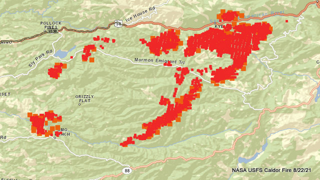
Grizzly Flat, CA…The Fire Activity Increased In The Early Portion Of The Day Due To Southwest Winds Surfacing Once The Inversion Dissipated. The Fire Also Experienced Growth On The Northeast Portion Due To Wind And Spotting Up To A Half-mile. Fire-damaged Timber Continues To Release In All Areas Causing Rollout And Ember Cast. Ignitions Are Established Easily In The Very Dry Receptive Fuel Bed.
To Better Provide Public And Firefighter Safety Due To Extreme Fire Conditions Throughout Northern California, And Strained Firefighter Resources Throughout The Country, The Usda Forest Service Pacific Southwest Region Is Announcing A Temporary Closure Of Nine National Forests. This Closure Will Be Effective On August 22, 2021, At 11:59 P.m. Through September 6, 2021, At 11:59 P.m. The Closure Order Can Be Found At Https://tinyurl.com/usfsclosure. Please Register For Codered Through The Local County Sheriff’s Office El Dorado County Code Red: Https://ready.edso.org/ Amador County Codered: Https://www.amadorsheriff.org/administration-division/codered
Current Situation
Total Personnel 1,618
Size 104,309 Acres
Percent of Perimeter Contained 5%
Estimated Containment Date Tuesday August 31st, 2021 approx. 12:00 AM
Fuels Involved
Heavy timber. Steep terrain.
Expected Full Containment: August 31, 2021
First Responder Fatalities: 0 First Responder Injuries: 0 Civilian Fatalities: 0 Civilian Injuries: 2
Structures Threatened: 17,488 Structures Damaged: 22 Single Residences Destroyed: 345 Commercial Properties Destroyed: 6 Other Minor Structures Destroyed: 124
EL DORADO COUNTY MANDATORY EVACUATIONS ORDERS:
– Grizzly Flat: The areas on Grizzly Flats Road east of Kendra Way into Grizzly Flats Proper. The areas of Diamond Railroad Grade, Old School House, Sweeney Road, Caldor Road, and steely Ridge.
• Grizzly Flats Road east of four corners in Somerset into Grizzly Flats Proper.
– The areas of Myers Lane, Varmet Ridge Road, Rodwell Canyon Road, Snowbird Lane, and Mehwald Lane.
• East of Sly Park Road between Highway 50 and Mormon Emigrant Trail to Ice House Road. This includes the communities of Pacific House and Fresh Pond.
• North of Highway 50 ,east of Forebay Road to Ice House Road.
• Intersection of Perry Creek and Hawk Haven , the East side of Fairplay Road from Perry Creek South to Cedarville Road. This includes Slug Gulch, Omo Ranch, and all roads off of Slug Gulch and Omo Ranch.
• All roads off of Omo Ranch from Cedarville Road to Hwy 88.
• The area between Highway 88 and Mormon Emigrant Trail
• South of Highway 50 from Snows Road to Ice House Road.
• Between Highway 50 and Slab Creek from Snows Road to Ice House Road.
– South of Highway 50 from Ice House Road to Silver Fork Road. This includes the community of Kyburz.
• North of Highway 50 from Ice House Road to Silver Fork Road to include Ice House Reservoir, Union Valley Reservoir, and Loon Lake.
EVACUATION WARNINGS:
-North of Slab Creek to Wentworth Springs Road between Sand Mountain and Loon Lake.
• Mosquito Road from the bridge North to include the Community of Swansboro.
• North of Highway 50 to Slab Creek between Smith Flat and Snows Road.
• South of Highway 50 to Pleasant Valley between Smith Flat and Snows Road, and North of Pleasant Valley between Holm and Newtown.
• South of Pleasant Valley between Bucks Bar Road and Newtown Road, East of Bucks Bar Road to Mt Aukum Road.
• Southwest of Bucks Bar Road to Ladies Valley Road including the community of Outingdale, Ant Hill Road, Perry Creek Road and Sand Ridge between Ladies Valley Road and Bucks Bar Road.
• East of Mt Aukum Road (E16) from Bucks Bar Road to Omo Ranch Road. North of Omo Ranch Road to the intersection of Omo Ranch Road and Fairplay Road.
• South of Omo Ranch to the El Dorado County Line between Mt Aukum Road (E16) and Fairplay Road to include Coyoteville Road, Cedar Creek and all tributary roads.
• North of Slab Creek to Wentworth Springs Road between Sand Mountain and Loon Lake.
• Mosquito Road from the bridge North to include the Community of Swansboro.
• North of Highway 50 to Slab Creek between Smith Flat and Snows Road.
• Silver Fork Road in Kyburz east to Twin Bridges.
• North and south in a line extending from Twin Bridges to the Placer County line and south to the Amador County line.
AMADOR COUNTY – EVACUATION WARNINGS
– Shenandoah Road at the Amador County line west through the River Pines community, continuing west on Shenandoah Road to Ostrom Road. South on Ostrom Road to Jibboom Street, West on Jibboom Street to Fiddletown Road. East on Fiddletown Road to Hale Road. South on Hale Road to Shake
Ridge Road. East on Shake Ridge Road to Charleston Road. South on Charleston Road to the intersection of Charleston Road and Rams Horn Grade. Due east to Highway 88 at Tiger Creek Road. Tiger Creek Road east
to Salt Springs Reservoir Road. East on Salt Springs Reservoir Road to the east end of the Salt Springs Reservoir. Due north from the east end of Salt
Springs Reservoir to Highway 88.
– South of the El Dorado-Amador County line with a western border of Highway 88 due south to the east end of Salt Springs Reservoir. Southern border of the Calaveras County line. Eastern border of the Alpine County line.
SHELTER INFORMATION:
– Shelter
Green Valley Community Church
3500 Missouri Flat Road
Placerville, CA
– Shelter- FULL
Cameron Park CSD
2502 Country Club Drive
Cameron Park, CA
– Temporary Evacuation Point
Amador County Fairgrounds
18621 Sherwood Street
Plymouth, CA
– Shelter
Evelynn Bishop Hall
701 Hwy 124
Ione, CA
855-755-7711
– Shelter
Rolling Hills Church
800 White Rock Road
El Dorado Hills, CA
ANIMAL EVACUATION INFORMATION:
– El Dorado County Animal Services (small animals)
6435 Capitol Ave.
Diamond Springs, CA
For animal evacuation questions or assistance call (530) 621-5795
– Saureel Vineyards (large animals)
1140 Cold Springs Road
Placerville, CA
(530) 621-5795
– Amador County Fairgrounds (large animal)-
18621 Sherwood Street
Plymouth, CA
Caldor Burns to 104,309 Acres, 5% Contained, 345 Homes & 6 Commercial Buildings Destroyed added by admin on
View all posts by admin →