

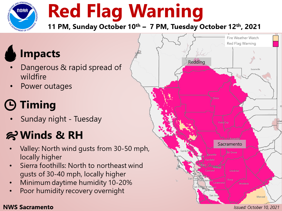
Sacramento, CA…Red Flag Warning late this evening into Tuesday evening for the Central Valley, Coast Range, and the foothill and lower elevations of the southern Cascades…and Monday afternoon into Tuesday evening across the northern Sierra foothills. Gusty north to northeast winds will develop late tonight and continue through Tuesday across much of interior Northern California. The strongest, most impactful, winds are expected on Monday across the Central Valley and foothills of the Coast Range. These winds combined with low humidity and dry fuels will lead to critical fire weather conditions into Tuesday evening.
weather.gov
National Weather Service
Watches, Warnings & Advisories
Go to the NOAA Homepage
NWS Homepage
Local weather forecast by “City, St” or zip code
City, St
One product issued by NWS for: Murphys CAShare|
Red Flag Warning
URGENT – FIRE WEATHER MESSAGE
National Weather Service Sacramento CA
315 AM PDT Sun Oct 10 2021
…Red Flag Warning late this evening into Tuesday evening for
the Central Valley, Coast Range, and the foothill and lower
elevations of the southern Cascades…and Monday afternoon into
Tuesday evening across the northern Sierra foothills…
.Gusty north to northeast winds will develop late tonight and
continue through Tuesday across much of interior Northern
California. The strongest, most impactful, winds are expected on
Monday across the Central Valley and foothills of the Coast Range.
These winds combined with low humidity and dry fuels will lead to
critical fire weather conditions into Tuesday evening.
CAZ220-267-102300-
/O.UPG.KSTO.FW.A.0009.211011T1800Z-211013T0200Z/
/O.NEW.KSTO.FW.W.0013.211011T1800Z-211013T0200Z/
Southern Motherlode From 1000 to 3000 Ft. Includes portions of
Calaveras-Tuolumne Unit-
Northern Motherlode From 1000 to 3000 Ft. Includes portions of
Nevada-Yuba-Placer-Amador and ElDorado Units-
315 AM PDT Sun Oct 10 2021
…RED FLAG WARNING IN EFFECT FROM 11 AM MONDAY TO 7 PM PDT
TUESDAY FOR GUSTY WINDS AND LOW HUMIDITY FOR FIRE WEATHER ZONES
220 AND 267…
The National Weather Service in Sacramento has issued a Red Flag
Warning, which is in effect from 11 AM Monday to 7 PM PDT
Tuesday. The Fire Weather Watch is no longer in effect.
* AFFECTED AREA…Foothills of the northern Sierra Nevada.
* WIND…North to northeast wind gusts of 30 to 40 mph, locally
higher near favored gaps and canyons. Strong winds will develop
Monday and continue Tuesday.
* HUMIDITY…Minimum humidity 15 to 20 percent. Overnight recovery
30 to 45 percent.
* IMPACTS…Any fires that develop will likely spread rapidly.
Outdoor burning is not recommended.
PRECAUTIONARY/PREPAREDNESS ACTIONS…
A Red Flag Warning means that critical fire weather conditions
are either occurring now, or will shortly. A combination of
strong winds, low relative humidity, and warm temperatures can
contribute to extreme fire behavior.
&&
Interact with us via social media
www.facebook.com/nws.sacramento
www.twitter.com/nwssacramento
$$
U.S. Dept. of Commerce
NOAA National Weather Service
1325 East West Highway
Silver Spring, MD 20910
E-mail: w-nws.webmaster@noaa.gov
Page last modified: May 16, 2007
Disclaimer
Credits
Glossary
Privacy Policy
About Us
Career Opportunities
NATIONAL WEATHER SERVICE: for Safety, for Work, for Fun – FOR LIFE
Red Flag Warning & Blustery Winds Tomorrow Through Tuesday added by admin on
View all posts by admin →