


Arnold, CA…Ladies & Gents, Lads & Lasses the storm door is opening and moisture is in your forecast for the next week. The Forecasts from the National Service for the West Slope & Mother Lode are below.
Detailed forecast for
West Slope Northern Sierra Nevada
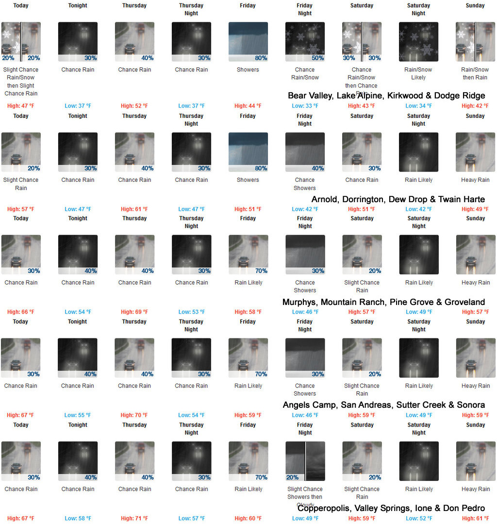
Today
Mostly cloudy. At lower elevations, a chance of rain. At higher elevations, a chance of rain and snow in the morning, then a chance of rain in the afternoon. Highs 40 to 55 higher elevations…50 to 65 lower elevations. No snow accumulation lower elevations…up to 1 inch higher elevations. Snow level 7500 feet in the morning. Prevailing south winds 5 to 15 mph with gusts to around 35 mph…except southwest 15 to 30 mph over ridges.
Tonight
Cloudy with a chance of rain. Lows 32 to 47 higher elevations…41 to 55 lower elevations. Prevailing south winds 5 to 15 mph with gusts to around 30 mph.
Thursday
Mostly cloudy with a chance of rain. Not as cool. Highs 45 to 60 higher elevations…54 to 68 lower elevations. Prevailing south winds 5 to 15 mph.
Thursday Night
Mostly cloudy with a chance of rain. Lows 32 to 47 higher elevations…43 to 53 lower elevations. Prevailing south winds up to 15 mph.
Friday
Rain in the morning, then rain showers likely and a slight chance of thunderstorms in the afternoon. Highs 38 to 53 higher elevations…49 to 58 lower elevations. Prevailing southwest winds 5 to 15 mph with gusts to around 35 mph…except southwest 20 to 30 mph over ridges.
Friday Night
Cloudy with a chance of rain and snow showers. Colder. Lows 30 to 45.
Saturday
Mostly cloudy with a chance of rain and snow. Highs 40 to 55.
Saturday Night
Rain and snow likely. Light snow accumulations possible. Lows 31 to 46.
Sunday And Sunday Night
Heavy rain. Breezy. Highs 40 to 55. Lows 31 to 46.
Monday
Heavy rain and snow. Heavy snow accumulations possible. Highs 35 to 50.
Monday Night
Mostly cloudy with rain and snow showers likely. Colder. Moderate snow accumulations possible. Lows 24 to 39.
Tuesday
Mostly cloudy with a chance of rain and snow showers. Highs 37 to 52.
Detailed forecast for Motherlode
Today
Cloudy with a chance of rain. Highs 55 to 70. Prevailing southeast winds 5 to 15 mph.
Tonight
Cloudy with a chance of rain. Lows 46 to 60. Prevailing southeast winds up to 10 mph.
Thursday
Mostly cloudy. Rain likely in the morning, then a chance of rain in the afternoon. Warmer. Highs 59 to 73. Prevailing south winds up to 10 mph.
Thursday Night
Mostly cloudy with a chance of rain. Lows 47 to 57. Prevailing southeast winds up to 10 mph.
Friday
Heavy rain in the morning, then rain showers likely and a slight chance of thunderstorms in the afternoon. Highs 54 to 62. Prevailing southwest winds up to 15 mph.
Friday Night
Mostly cloudy with a slight chance of rain showers. Colder. Lows 41 to 51.
Saturday
Mostly cloudy with a slight chance of rain. Highs 51 to 61.
Saturday Night Through Monday
Heavy rain. Lows 43 to 55. Highs 48 to 61.
Monday Night And Tuesday
Mostly cloudy with a chance of rain showers. Lows 37 to 49. Highs 48 to 60.
The Drought & Fire Season Are Over! (Well, Not Really but Next Few Days Sure Look Good!!) added by admin on
View all posts by admin →