


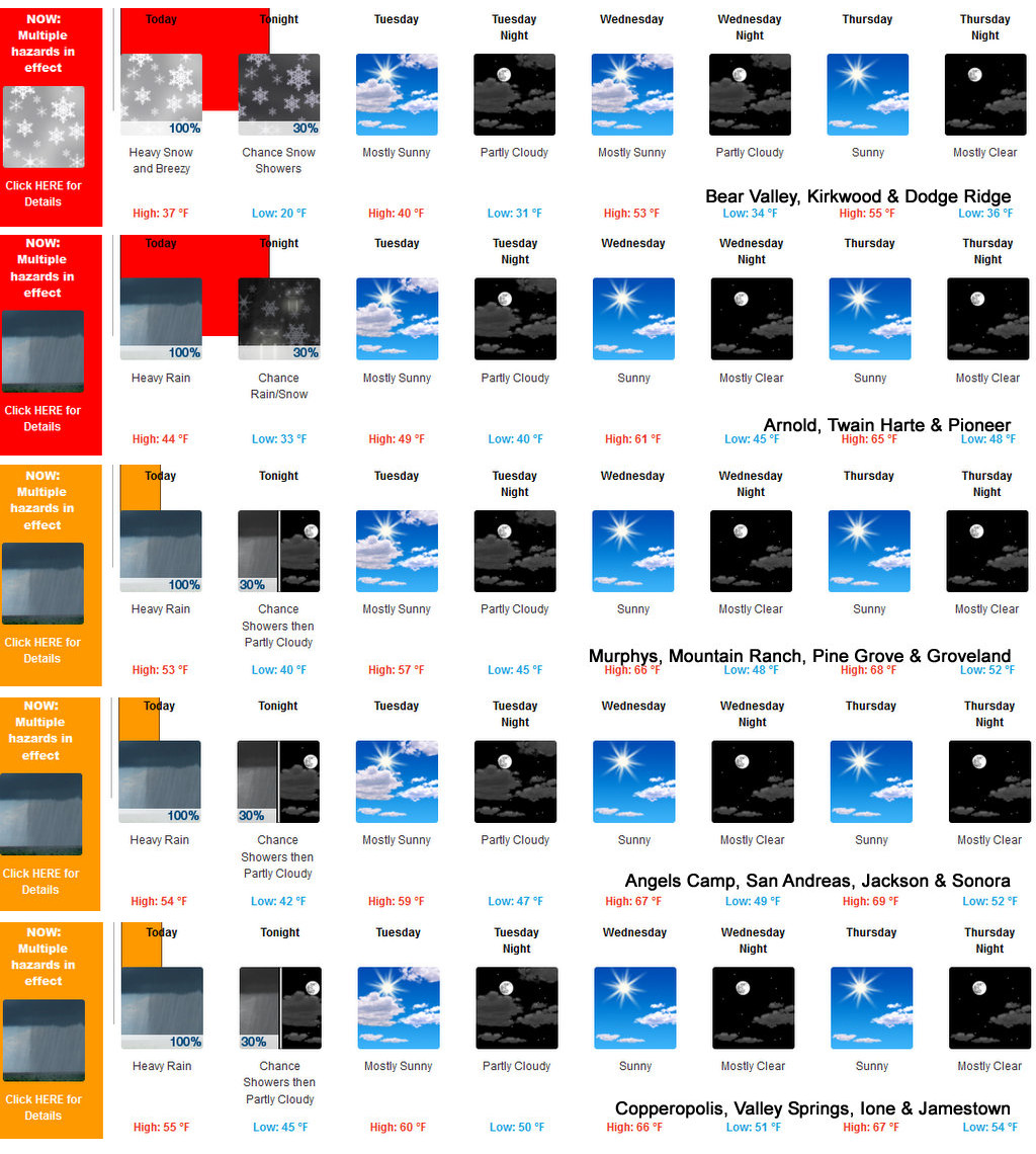
Arnold, CA…The calm after the storm begins today. Over a foot of snow may fall at higher elevations as this system cools as it exits. The latest from the National Weather Service for the West Slope & Mother Lode are below…
Detailed forecast for
West Slope Northern Sierra Nevada
Today
Heavy rain showers at lower elevations…and heavy snow showers and heavy rain showers at higher elevations. Highs 30 to 45 higher elevations…41 to 51 lower elevations. No snow accumulation lower elevations…7 to 13 inches higher elevations. Snow level 6500 feet decreasing to 5500 feet in the afternoon. Prevailing southwest winds 5 to 15 mph. Gusts up to 40 mph in the morning. Over ridges…prevailing southwest winds 20 to 30 mph decreasing to 10 to 20 mph in the afternoon.
Tonight
Mostly cloudy. At lower elevations, a chance of rain showers. At higher elevations, a chance of rain and snow showers. Colder. Lows 18 to 33 higher elevations…31 to 42 lower elevations. No snow accumulation lower elevations…up to 1 inch higher elevations. Snow level 5500 feet. Prevailing south winds up to 10 mph.
Tuesday
Mostly cloudy in the morning then becoming partly cloudy. At lower elevations, a chance of rain showers. At higher elevations, a chance of snow showers in the morning, then a chance of rain and snow showers in the afternoon. Not as cool. Highs 34 to 49 higher elevations…44 to 56 lower elevations. Snow level 5000 feet increasing to 6500 feet in the afternoon. Prevailing south winds 5 to 15 mph shifting to the southwest in the afternoon.
Tuesday Night
Mostly cloudy with a slight chance of rain showers. Lows 26 to 41 higher elevations…37 to 47 lower elevations. Prevailing southwest winds up to 10 mph shifting to the east after midnight.
Wednesday
Partly cloudy in the morning then clearing. Warmer. Highs 47 to 62 higher elevations…59 to 67 lower elevations. Prevailing north winds up to 10 mph.
Wednesday Night
Mostly clear. Lows 33 to 48.
Thursday
Mostly sunny. Warmer. Highs 53 to 68.
Thursday Night Through Friday Night
Mostly clear. Lows 35 to 50. Highs 53 to 68.
Saturday
Partly cloudy. Highs 48 to 63.
Saturday Night And Sunday
Mostly clear. Lows 32 to 47. Highs 46 to 61.
Detailed forecast for
Motherlode
Today
Heavy rain showers in the morning, then rain showers and a slight chance of thunderstorms in the afternoon. Highs 47 to 57. Prevailing southwest winds up to 15 mph. Gusts up to 30 mph in the morning.
Tonight
Mostly cloudy. A chance of rain showers in the evening, then a slight chance of rain showers after midnight. Colder. Lows 36 to 48. Prevailing south winds up to 10 mph shifting to the southeast after midnight.
Tuesday
Mostly cloudy with a slight chance of rain showers. Highs 49 to 61. Prevailing southeast winds up to 10 mph shifting to the southwest in the afternoon.
Tuesday Night
Mostly cloudy with a slight chance of rain showers. Lows 41 to 51. Prevailing southwest winds up to 10 mph in the evening becoming light.
Wednesday
Partly cloudy in the morning then clearing. Warmer. Highs 62 to 68. Prevailing northeast winds up to 10 mph shifting to the northwest in the afternoon.
Wednesday Night
Mostly clear. Lows 45 to 53.
Thursday
Mostly sunny. Highs 64 to 72.
Thursday Night Through Saturday Night
Mostly clear. Lows 44 to 56. Highs 61 to 73.
Sunday
Mostly sunny. Highs 56 to 66.
Sunshine Returns Tomorrow as Last of System Moves East added by admin on
View all posts by admin →