


Arnold, CA…The latest Detailed forecast for West Slope Northern Sierra Nevada from the National Weather Service in Sacramento is below. Today, Snow showers likely. Highs 17 to 32 higher elevations… 30 to 40 lower elevations. Snow accumulation of 1 to 5 inches lower elevations…except 2 to 8 inches higher elevations. Prevailing southwest winds up to 15 mph with gusts to around 30 mph…except west 10 to 25 mph over ridges.
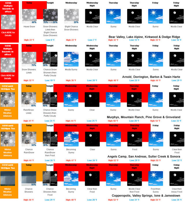
Tonight
Mostly cloudy in the evening then becoming mostly clear. At lower elevations, a chance of snow showers in the evening. At higher elevations, snow showers likely in the evening, then a slight chance of snow showers after midnight. Colder. Lows 2 to 17 higher elevations…14 to 26 lower elevations. Prevailing northwest winds up to 10 mph shifting to the northeast after midnight.
Wednesday
Partly cloudy in the morning then clearing. At higher elevations, a slight chance of snow showers in the afternoon. Not as cold. Highs 19 to 34 higher elevations…34 to 44 lower elevations. Prevailing northeast winds 5 to 15 mph.
Wednesday Night
Clear. Lows 3 to 18 higher elevations…15 to 27 lower elevations. Prevailing northeast winds 5 to 15 mph.
Thursday
Sunny. Not as cool. Highs 26 to 41 higher elevations…38 to 48 lower elevations. Prevailing east winds up to 10 mph shifting to the west in the afternoon.
Thursday Night
Mostly clear. Lows 12 to 27.
Friday
Sunny. Not as cool. Highs 33 to 48.
Friday Night
Clear. Lows 15 to 30.
Saturday
Mostly sunny. Not as cool. Highs 39 to 54.
Saturday Night
Partly cloudy. Lows 22 to 37.
Sunday
Mostly cloudy with a slight chance of rain and snow showers. Not as cool. Highs 42 to 57.
Sunday Night
Partly cloudy with a slight chance of rain and snow showers. Lows 24 to 39.
Monday
Mostly sunny. Highs 44 to 59.
Winter Storm Warning Until this Evening & Chance of Moisture Again on Sunday added by admin on
View all posts by admin →