


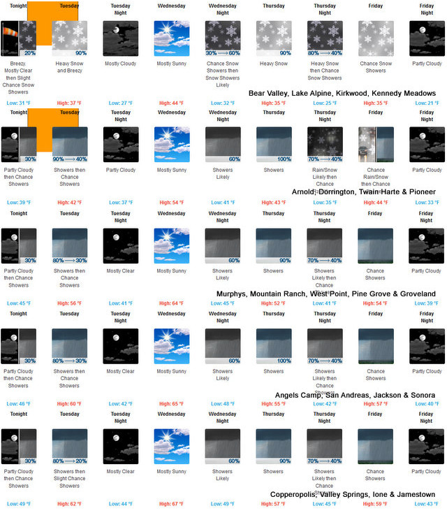
Arnold, CA…The Latest Detailed forecast for the West Slope Northern Sierra Nevada from the National Weather Service. Tonight Partly cloudy in the evening. At lower elevations, a slight chance of rain showers late in the evening. A chance of rain showers after midnight, then rain showers late in the night. At higher elevations, a chance of rain and snow showers after midnight. Snow showers and rain showers late in the night. Breezy. Lows 25 to 39 higher elevations…35 to 45 lower elevations. No snow accumulation lower elevations…2 to 4 inches higher elevations. Snow level 7000 feet. Prevailing southwest winds 15 to 25 mph with gusts to around 45 mph…except southwest 25 to 40 mph over ridges.
Tuesday
Mostly cloudy. At lower elevations, rain showers in the morning, then a slight chance of rain showers in the afternoon. At higher elevations, heavy rain and snow showers in the morning, then a chance of rain and snow showers in the afternoon. Breezy. Highs 31 to 46 higher elevations…44 to 54 lower elevations. No snow accumulation lower elevations…1 to 7 inches higher elevations. Snow level 6000 feet. Prevailing southwest winds 15 to 25 mph decreasing to 5 to 15 mph in the afternoon. Gusts up to 45 mph. Over ridges…prevailing southwest winds 20 to 35 mph.
Tuesday Night
Mostly cloudy in the evening then becoming partly cloudy. Colder. Lows 21 to 36 higher elevations…33 to 43 lower elevations. Prevailing south winds 5 to 15 mph with gusts to around 30 mph…except southwest 15 to 30 mph over ridges.
Wednesday
Partly cloudy. A chance of rain and snow showers in the afternoon. Not as cool. Highs 37 to 52 higher elevations… 47 to 61 lower elevations. Snow level 6000 feet. Prevailing southwest winds 10 to 20 mph with gusts to around 35 mph…except southwest 15 to 30 mph over ridges.
Wednesday Night
Mostly cloudy. A chance of rain and snow showers in the evening, then rain and snow showers likely after midnight. Lows 25 to 39 higher elevations…36 to 46 lower elevations. No snow accumulation lower elevations…1 to 7 inches higher elevations. Snow level 6500 feet. Prevailing southwest winds 10 to 20 mph with gusts to around 40 mph…except southwest 20 to 35 mph over ridges.
Thursday
Rain showers, heavy snow showers and a slight chance of thunderstorms. Heavy snow accumulations possible. Highs 33 to 48.
Thursday Night
Mostly cloudy with rain and snow showers likely. Colder. Moderate snow accumulations possible. Lows 23 to 38.
Friday
Mostly cloudy with a chance of rain and snow showers. Highs 34 to 49.
Friday Night
Partly cloudy. Lows 21 to 36.
Saturday
Mostly sunny. Not as cool. Highs 43 to 58.
Saturday Night
Clear. Lows 26 to 41.
Sunday Through Monday
Mostly clear. Highs 51 to 66. Lows 28 to 43.
Detailed forecast for Motherlode
Tonight
A chance of rain showers after midnight. Rain showers late in the night. Lows 41 to 50. Prevailing southwest winds 5 to 15 mph shifting to the southeast after midnight. Gusts up to 30 mph.
Tuesday
Mostly cloudy. A chance of rain showers in the morning, then a slight chance of rain showers in the afternoon. Highs 51 to 63. Prevailing southwest winds up to 15 mph.
Tuesday Night
Mostly clear. Lows 37 to 45. Prevailing southwest winds up to 10 mph shifting to the east after midnight.
Wednesday
Mostly sunny in the morning, then partly cloudy with a chance of rain showers in the afternoon. Warmer. Highs 54 to 68. Prevailing southeast winds up to 10 mph shifting to the south in the afternoon.
Wednesday Night
Mostly cloudy. A chance of rain showers in the evening, then rain showers after midnight. Lows 41 to 51. Prevailing south winds 5 to 15 mph.
Thursday
Rain showers and a slight chance of thunderstorms. Highs 46 to 58.
Thursday Night
Mostly cloudy with a chance of rain showers and a slight chance of thunderstorms. Lows 37 to 45.
Friday
Mostly cloudy with a chance of rain showers. Highs 49 to 61.
Friday Night And Saturday
Mostly clear. Lows 35 to 43. Highs 52 to 67.
Saturday Night And Sunday
Clear. Lows 41 to 47. Highs 60 to 75.
Sunday Night And Monday
Mostly clear. Lows 43 to 51. Highs 65 to 78.
Winter Weather Advisory
URGENT – WINTER WEATHER MESSAGE
National Weather Service Sacramento CA
233 PM PDT Mon Apr 18 2022
CAZ069-191400-
/O.CON.KSTO.WW.Y.0011.220419T0900Z-220419T2100Z/
West Slope Northern Sierra Nevada-
233 PM PDT Mon Apr 18 2022
…WINTER WEATHER ADVISORY REMAINS IN EFFECT FROM 2 AM TO 2 PM
PDT TUESDAY ABOVE 6500 FEET…
* WHAT…Snow expected. Plan on difficult travel conditions,
including during the morning commute on Tuesday. Tree branches
could fall as well. Total snow accumulations of 4 to 7 inches,
with localized amounts up to 10 inches, are expected.
* WHERE…West Slope Northern Sierra Nevada.
* WHEN…2 AM to 2 PM Tuesday.
* ADDITIONAL DETAILS…Be prepared for reduced visibilities at
times.
PRECAUTIONARY/PREPAREDNESS ACTIONS…
A Winter Weather Advisory for snow means periods of snow will
cause primarily travel difficulties. Be prepared for snow covered
roads and limited visibilities, and use caution while driving.
The latest road conditions for the state you are calling from can
be obtained by calling 5 1 1.
$$
Sun, Rain, Snow, Winter Weather Advisories & More. A Bit of Everything in Our Weather This Week! added by admin on
View all posts by admin →