


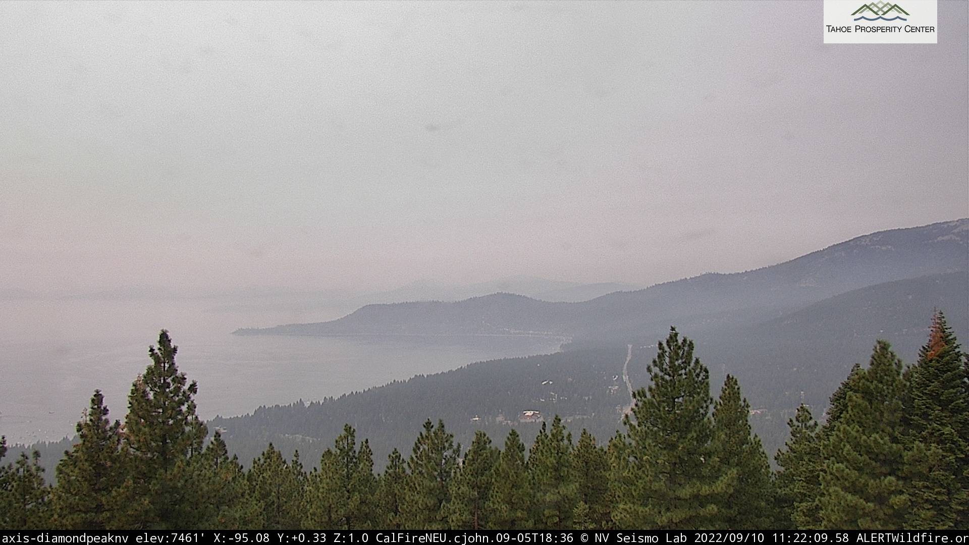
Foresthill, CA…The Mosquito Fire was detected the evening of Tuesday, September 6, and is actively burning actively near Oxbow Reservoir, 4 miles east of Foresthill, in brush and timber in very steep and rugged terrain. The fire was less active overnight Friday than previous nights. Cooler, more humid weather conditions Saturday should reduce fire behavior somewhat, but the vegetation remains critically dry and will burn readily. The photo below is of smoke impacting Tahoe area from Diamond Peak above Incline Village, NV.
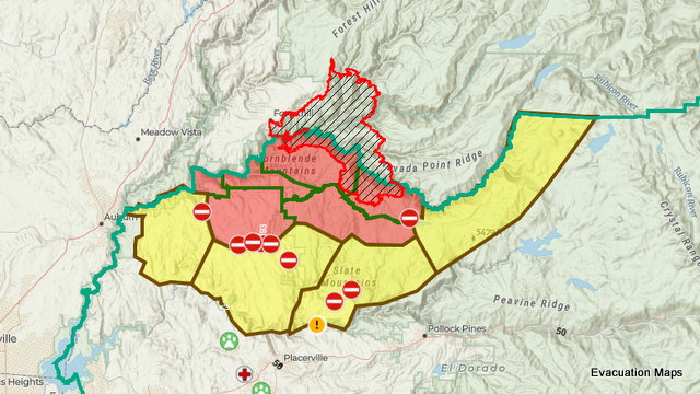
Sheriff’s Offices in Placer County and El Dorado County have issued evacuation orders and warnings for several communities and areas near the fire. Interactive maps are available for both counties:
Placer County evacuation map (PDF of evacuation zones and descriptions)
El Dorado County evacuation map (PDF of evacuation zones and descriptions)
The decision to evacuate a community is done with an understanding of the inconvenience it places on those who live and work in a community but with the priority of life safety. Ensure that you are prepared and ready to evacuate at a moment’s notice.
Tahoe National Forest: Facebook, Twitter (@Tahoe_NF)
Tahoe National Forest closure order and map: Forest Order No. 17-22-09
Eldorado National Forest: Facebook, Twitter (@EldoradoNF)
Eldorado National Forest closure order and map: Forest Order No. 03-22-16
CAL FIRE AEU: Facebook, Twitter (@calfireaeu)
CAL FIRE NEU: Facebook, Twitter (@calfireneu)
Basic Information
| Current as of | 9/10/2022, 10:32:27 AM |
| Incident Type | Wildfire |
| Cause | Under Investigation |
| Date of Origin | Tuesday September 06th, 2022 approx. 06:27 PM |
| Location | 4 miles east of Foresthill and north of Oxbow Reservoir |
| Incident Commander | Rick Young (California Interagency IMT 5), Jim Hudson (CAL FIRE), and Dusty Miller (CAL FIRE) |
| Coordinates | 39.006 latitude, -120.745 longitude |
Current Situation
| Total Personnel | 1,565 |
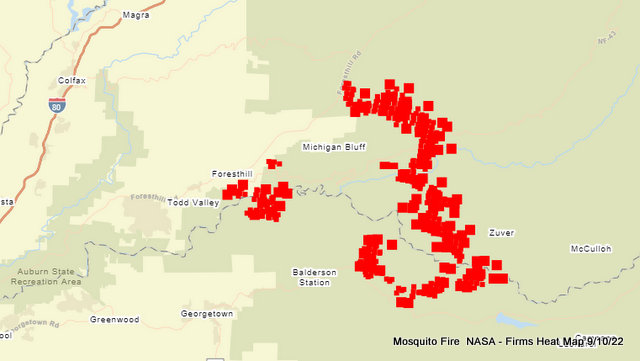
| Size | 33,754 Acres |
| Fuels Involved | Vegetation–timber, brush, and hardwood litter–is critically dry. Any beneficial effects of a relative-humidity increase will be slight and brief. Vegetation will remain primed for extreme fire behavior. |
| Significant Events | Observed fire behavior was moderate, consisting of uphill runs, torching, and flanking. On Friday, fire behavior was moderated by late dissipation of the smoke inversion layer. |
Outlook
| Planned Actions | * Provide structure defense and point protection for values at risk.
* Protect private timberlands. * Scout for opportunities to construct containment lines. * Perform firing operations where appropriate. * Construct direct and indirect line as conditions and opportunities allow. |
| Projected Incident Activity | The fire has been burning actively overnight. Higher relative humidity Saturday may provide a slight and temporary decrease in fire behavior, but expect very active fire growth overnight. |
| Remarks | The fire is being managed under unified command between the USDA Forest Service, California Incident Incident Management Team 5 (Type 1), CAL FIRE, and Placer County Sheriff. |
Current Weather
| Weather Concerns | On Saturday, critically hot, dry conditions will moderate slightly with the moisture effects from Hurricane Kay. Relative humidity will be slightly higher and temperatures slightly cooler (into the 90s). No major wind events are anticipated, and diurnal wind patterns will preside. Considerable fire growth and smoke plume development are possible. Winds aloft will shift east to southwest to west to southeast with the passage of the remnants of Hurricane Kay. |
Recent Articles
Related Links
- National Fire Situational Awareness (NFSA) Tool
- Tahoe NF Twitter
- CAL FIRE Mosquito Fire Incident Page
- Placer County Evacuation Map
- Tahoe NF Facebook
- El Dorado County evacuation & shelter location map
- Fire and Smoke Map from airnow.gov
Incident Cooperators
- CAL FIRE
- California Highway Patrol
- Eldorado County Sheriff
- Foresthill Fire Protection District
- Governor’s Office of Emergency Services
- Placer County Sheriff
September 10th Mosquito Fire Update, 33,754 Acres & Rate of Growth Slows added by admin on
View all posts by admin →