


Foresthill, CA…Overnight fire behavior was moderate. The reported acreage Monday morning is unchanged from Sunday night because the overnight infrared flight that collects perimeter data was cancelled due to abundant cloud cover. An updated acreage estimate will be provided as soon as other sources provide adequate information to determine the current perimeter. Night-shift crews on the west side of the fire aggressively extinguished hotspots along the fireline from the Foresthill area northwestward to Michigan Bluff. Crews working on the southwest side between Foreshill and Volcanoville had to cease the firing operation in the Buckeye Point area due to a small amount of precipitation. That mission will be the priority for the day shift on Monday.
Evacuations:
Numerous evacuation orders and warnings are in effect for both Placer County and El Dorado County. If you have not already evacuated, do so if you are under an evacuation order. If you are under a warning, ensure that you are prepared and ready to evacuate at a moment’s notice.
The best place to view the evacuation zones and where you are in relation to them is your county’s live interactive maps:
Placer County evacuation map (PDF of evacuation zones and descriptions)
El Dorado County evacuation map (PDF of evacuation zones and descriptions)
The decision to evacuate a community is done with an understanding of the inconvenience it places on those who live and work in a community, but the safety and lives of community members is obviously a priority. The incident management team, incident commanders, sheriffs, and others meet daily and communicate frequently about fire behavior and assess the evacuation situation. Information will be quickly widely and disseminated when decisions are made to issue or rescind evacuation orders or warnings.
Basic Information
| Current as of | 9/12/2022, 7:13:09 AM |
| Incident Type | Wildfire |
| Cause | Under Investigation |
| Date of Origin | Tuesday September 06th, 2022 approx. 06:27 PM |
| Location | 4 miles east of Foresthill and north of Oxbow Reservoir |
| Incident Commander | Rick Young (CIIMT 5), Jim Hudson (CAL FIRE), Dusty Martin (CAL FIRE), Connie Schmidt (PCSO) |
| Coordinates | 39.006 latitude, -120.745 longitude |
Current Situation
| Total Personnel | 2,397 |
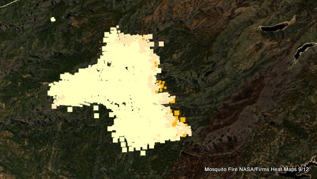
| Size | 46,587 Acres |
| Percent of Perimeter Contained | 10% |
| Fuels Involved | Vegetation–timber, brush, and hardwood litter–is critically dry. Any beneficial effects of a relative-humidity increase will be slight and brief. Vegetation will remain primed for extreme fire behavior. |
| Significant Events | Fire behavior Sunday night was moderate, consisting of flanking, backing, and isolated torching.The relative humidity increased, limiting fire behavior. Trace amount of precipitation fell in the Foresthill area. |
Outlook
| Planned Actions | * Provide structure defense and point protection for values at risk.
* Protect private timberlands. * Scout for opportunities to construct containment lines. * Perform firing operations where appropriate. * Construct direct and indirect line as conditions and opportunities allow. |
| Projected Incident Activity | 12-hour time frame:
Increased transport winds and better mixing will allow ventilation, although cooler temperatures and higher relative humidity will lessen this impact. Still, increased fire behavior is anticipated, especially with the southwest flow driving the fire upslope and into canyons. Deadwood Ridge, Chicken Hawk Ridge, Ralston Ridge, Long Canyon, Middle Fork American River, and Rubicon River start to come into alignment for fire spread. 24-hour time frame: Atmospheric mixing continues to increase, allowing the fire to breathe. The extremely dry vegetation, stressed by the record-breaking September heat wave, will generate even more heat as it burns, which will lead to more mixing and air flow. Sunny skies will allow a smoke plume to develop as record-breaking dry large vegetation is consumed and the fire moves into remote, rugged terrain. |
| Remarks | This Type 1 incident is being managed under unified command between the USDA Forest Service (California Interagency Incident Management Team 5), CAL FIRE, and Placer County Sheriff.
The fire is burning on federal (Tahoe National Forest and Eldorado National Forest) state, and private lands. |
The Mosquito Fire Now 46,587 Acres, 10% Containment, 2,397 Personnel added by admin on
View all posts by admin →