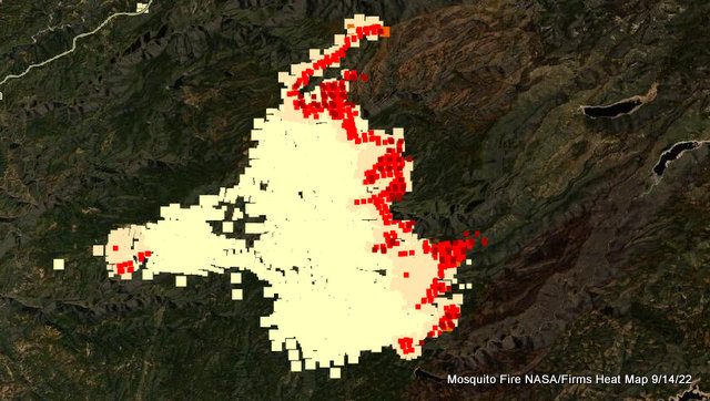
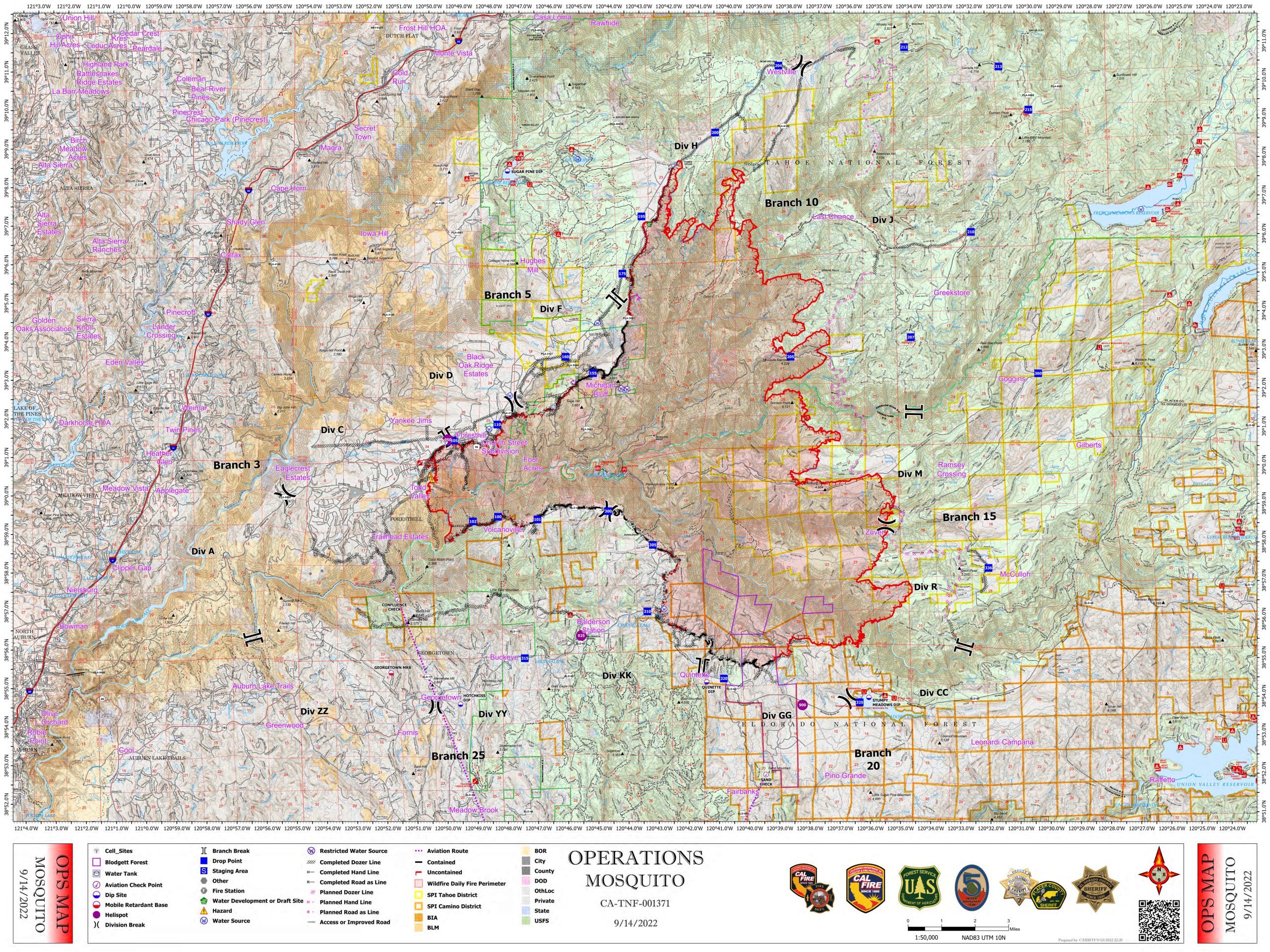
Foresthill, CA…The fire was active Tuesday night into Wednesday morning, particularly on the northeast side. Night-shift crews completed firing operations on the north side from Forks House Trailhead to the Deadwood Road. On the west side, south of Foresthill where the fire spotted over the Middle Fork of the American River Tuesday afternoon, fire activity did moderate overnight. The mission-critical priority for firefighters Wednesday is the west side of the fire; they will focus on protecting structures in the Foresthill and Todd Valley areas and increasing containment of the fireline to prevent further westward and northward spread. The southeast corner is also a priority as crews strive to halt the fire’s progression toward Stumpy Meadows. Numerous aircraft are supporting ground crews, conducting water and retardant drops during both day and night shifts. Read the morning update and watch the daily operational briefing (posted around 8:30 a.m.) for more detailed information on the current situation.
Evacuations:
Numerous evacuation orders and warnings are in effect for both Placer County and El Dorado County. If you have not already evacuated, do so if you are under an evacuation order. If you are under a warning, ensure that you are prepared and ready to evacuate at a moment’s notice. The best place to view the evacuation zones and where you are in relation to them is your county’s live interactive maps:
Placer County evacuation map (PDF of evacuation zones and descriptions – – UPDATED on September 13, 2022 – –)
El Dorado County evacuation map (PDF of evacuation zones and descriptions – – UPDATED on September 13, 2022 – – )
The decision to evacuate a community is done with an understanding of the inconvenience it places on those who live and work in a community, but public safety is obviously the priority. The incident management team, incident commanders, county sheriffs, and cooperators meet daily, communicate frequently about fire behavior, and continually assess the evacuation situation. Information will be quickly disseminated when decisions are made to issue or rescind evacuation orders or warnings.
Other Resources:
Mosquito Fire videos are available on YouTube (daily operations briefing, virtual community meetings, and more).
Daily Smoke Outlook: English | Español
Tahoe National Forest: Closure Order & Map (No. 17-22-09) | Fire Restrictions | Facebook | Twitter
Eldorado National Forest: Closure Order & Map (No. 03-22-16) | Fire Restrictions | Facebook | Twitter
CAL FIRE AEU: Facebook | Twitter
CAL FIRE NEU: Facebook | Twitter
Placer County: Mosquito Fire Information | Facebook | Twitter | Office of Emergency Services (530-866-5390)
El Dorado County: Mosquito Fire Information | Facebook | Twitter
Damage assessments:
Damage assessments have been completed for some communities affected by the fire. Placer County residents from Michigan Bluffs should call 530-886-5390 to inquire about the status of their property. El Dorado County residents should refer to the online structure-status map and enter their address in the search bar get information about the condition of their property.
Background:
The Mosquito Fire was detected the evening of Tuesday, September 6, and is actively burning east of Foresthill, California, predominantly on the Tahoe and Eldorado National Forests in Placer and El Dorado counties, respectively. The vegetation consists mainly of brush and timber, and the landscape in most places is very steep and rugged. Numerous communities are under evacuation orders and warnings in both counties. Road closures, National Forest closures, and fire restrictions are in effect. California Interagency Incident Management Team 5, a Type 1 team, is managing the fire in unified command with CAL FIRE and Placer County Sheriff’s Office.
Incident Information
Basic Information
| Current as of | 9/14/2022, 6:59:04 AM |
| Incident Type | Wildfire |
| Cause | Under Investigation |
| Date of Origin | Tuesday September 06th, 2022 approx. 06:27 PM |
| Location | 4 miles east of Foresthill and north of Oxbow Reservoir |
| Incident Commander | Rick Young (CIIMT 5), Jim Hudson (CAL FIRE), Dusty Martin (CAL FIRE), Connie Schmidt (PCSO) |
| Coordinates | 39.006 latitude, -120.745 longitude |
Current Situation
| Total Personnel | 3,052 |
| Size | 58,544 Acres |
| Percent of Perimeter Contained | 20% |
| Fuels Involved | Vegetation—timber, brush, chaparral, grass—is critically dry and primed for extreme fire behavior. |
| Significant Events | Fire behavior Tuesday night was active, consisting of backing, uphill runs, and group-tree torching. The fire remained active throughout the night into Wednesday morning. Conditions facilitated the firing operations that necessary to secure several miles of containment line. |
Outlook
| Planned Actions | * Provide structure defense and point protection for values at risk.
* Protect private timberlands. * Scout for opportunities to construct containment lines. * Perform firing operations where appropriate. * Construct direct and indirect line as conditions and opportunities allow. |
| Projected Incident Activity | 12-hour time frame:
A weak, cold dry front may influence the fire area starting early Wednesday. Clear skies and similar winds as Tuesday will continue to allow the fire to breathe. Sunnier skies will allow plume development as record-breaking dry heavy fuels are consumed and carry fire in remote, rugged terrain. Potential for fuels-driven fire with southwest winds continuing to push fire upslope and in canyons, especially with the passing cold front. Terrain will hamper access and control efforts. Extremely low fuel moistures stressed by the record-breaking September heatwave will generate even more heat to drive mixing and air flow. 24-hour time frame: After the frontal passage, fire behavior will moderate slightly with decreased wind speeds. Critically dry fuels will continue to burn readily and dramatically with clear air. Heavy fuels remain volatile and will not have moisture recovery until winter/spring. |
| Remarks | This Type 1 incident is being managed under unified command between the USDA Forest Service (California Interagency Incident Management Team 5), CAL FIRE, and Placer County Sheriff.
The fire is burning on federal (Tahoe National Forest and Eldorado National Forest) state, and private lands. |
Current Weather
| Weather Concerns | A weak weather system will exit the area Wednesday bringing continued breezy southwest winds this afternoon. The inversion should break early and ventilate the fire after 1 p.m. Mostly sunny conditions and good ventilation will increase solar heating of fuels, making them ready to burn.
Temperatures Wednesday will be below normal for mid- September (67–79 degrees). Humidity will be 27–35%. Southeast winds will be 2 to 5mph early in the day, increasing to 6–11 mph with gusts 15–20mph in the afternoon. |


