

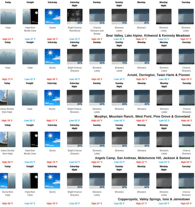
Arnold, CA…Ladies, Gents, Boys, Girls & Others we actually have a chance of snow at higher elevations! Of course we will welcome moisture in whatever form mother nature throws our way. The latest from the NWS follows…Detailed forecast for West Slope Northern Sierra Nevada. Today, Sunny. Areas of smoke through the day. Haze in the late morning and afternoon. Warmer. Highs 58 to 73 higher elevations… 69 to 79 lower elevations. Prevailing southeast winds up to 10 mph shifting to the southwest in the afternoon.
Tonight
Clear. Haze and areas of smoke. Lows 34 to 49 higher elevations…45 to 59 lower elevations. Prevailing west winds up to 10 mph shifting to the east after midnight.
Saturday
Areas of smoke in the morning. Sunny. Highs 53 to 68 higher elevations…65 to 77 lower elevations. Prevailing southeast winds up to 10 mph shifting to the southwest with gusts to around 30 mph in the afternoon.
Saturday Night
Mostly cloudy. A slight chance of rain showers after midnight. Colder. Lows 32 to 47 higher elevations…41 to 55 lower elevations. Snow level above 8000 feet. Prevailing south winds 5 to 15 mph with gusts to around 35 mph…except south 10 to 30 mph over ridges.
Sunday
Mostly cloudy. A chance of rain and snow showers in the morning, then rain showers likely in the afternoon. Highs 43 to 58 higher elevations…53 to 67 lower elevations. Little or no snow accumulation. Snow level above 8000 feet. Prevailing south winds 10 to 20 mph with gusts to around 35 mph…except south 10 to 30 mph with gusts to around 45 mph over ridges.
Sunday Night
Rain showers likely. Lows 36 to 51.
Monday
Rain showers and a slight chance of thunderstorms. Highs 46 to 61.
Monday Night
Mostly cloudy with rain showers likely and a slight chance of thunderstorms. Lows 34 to 49.
Tuesday
Mostly cloudy with a chance of rain showers and a slight chance of thunderstorms. Highs 47 to 62.
Tuesday Night And Wednesday
Mostly cloudy with a chance of rain showers. Lows 34 to 49. Highs 49 to 64.
Wednesday Night
Mostly clear. Lows 35 to 50.
Thursday
Sunny, warmer. Highs 60 to 75.
Detailed forecast for
Motherlode
Today
Sunny. Areas of smoke until late afternoon. Haze in the afternoon. Highs 74 to 82. Prevailing northeast winds up to 10 mph shifting to the west in the afternoon.
Tonight
Clear, haze. Lows 50 to 60. Light winds.
Saturday
Sunny. Highs 70 to 80. Light winds becoming southwest 5 to 15 mph in the afternoon.
Saturday Night
Mostly cloudy. A chance of rain showers after midnight. Lows 47 to 57. Prevailing southwest winds 5 to 15 mph shifting to the southeast after midnight.
Sunday
Rain showers likely. Highs 59 to 69. Prevailing south winds up to 15 mph.
Sunday Night
Rain showers likely. Lows 48 to 60.
Monday
Rain showers and a slight chance of thunderstorms. Highs 60 to 70.
Monday Night
Mostly cloudy with rain showers likely and a slight chance of thunderstorms. Lows 48 to 58.
Tuesday
Mostly cloudy with a chance of rain showers and a slight chance of thunderstorms. Highs 61 to 71.
Tuesday Night
Mostly cloudy with a chance of rain showers. Lows 47 to 57.
Wednesday
Partly cloudy with a slight chance of rain showers. Highs 65 to 75.
Wednesday Night
Mostly clear. Lows 49 to 59.
Thursday
Sunny. Highs 72 to 80.
Snow Flurries & Other Forms of Precipitation in Our Forecast! added by admin on
View all posts by admin →