


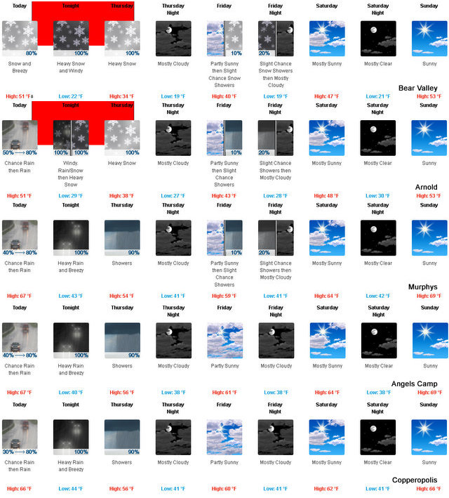
Bear Valley, CA…Mostly cloudy today at lower elevations…a chance of rain. At higher elevations…a slight chance of rain in the morning… Then rain and snow likely in the afternoon. Windy. Highs 44 to 59 higher elevations…51 to 65 lower elevations. No snow accumulation lower elevations…up to 1 inch higher elevations. Snow level above 8000 feet decreasing to 7000 feet in the afternoon. Prevailing south winds 10 to 20 mph increasing to 15 to 30 mph in the afternoon. Gusts up to 50 mph. Over ridges… Prevailing southwest winds 25 to 35 mph shifting to the south 25 to 45 mph in the afternoon.
Tonight
At lower elevations…rain in the evening…then heavy rain showers and heavy snow showers after midnight. At higher elevations…rain and snow in the evening…then heavy snow showers after midnight. Windy…colder. Lows 22 to 37 higher elevations…31 to 43 lower elevations. Snow accumulation 2 to 4 inches lower elevations…except 7 to 12 inches higher elevations. Snow level 6500 feet decreasing to 4500 feet after midnight. Prevailing south winds 15 to 30 mph. Over ridges…prevailing south winds 25 to 35 mph with gusts to around 50 mph shifting to the southwest 30 to 45 mph with gusts to around 60 mph after midnight.
Thursday
Heavy snow showers and heavy rain showers. Highs 29 to 43 higher elevations…38 to 48 lower elevations. Snow accumulation 3 to 5 inches lower elevations…except 4 to 6 inches higher elevations. Snow level 4000 feet. Prevailing southwest winds 10 to 20 mph with gusts to around 35 mph.
Thursday Night
Mostly cloudy with a slight chance of rain and snow showers. Lows 20 to 35 higher elevations…30 to 41 lower elevations. No snow accumulation lower elevations…up to 1 inch higher elevations. Snow level 5000 feet. Prevailing south winds up to 15 mph.
Friday
Mostly cloudy. A slight chance of rain and snow in the morning…then a chance of rain and snow in the afternoon. Not as cool. Highs 34 to 48 higher elevations…42 to 54 lower elevations. Snow level 5500 feet. Prevailing southwest winds up to 15 mph…except southwest 15 to 25 mph over ridges.
Friday Night
Mostly cloudy with a chance of rain and snow showers. Lows 24 to 39.
Saturday
Mostly cloudy. Not as cool. Highs 43 to 58.
Saturday Night And Sunday
Mostly clear. Lows 26 to 41. Highs 49 to 64.
Sunday Night Through Monday Night
Clear. Lows 31 to 46. Highs 55 to 70.
Tuesday
Partly cloudy. Highs 51 to 66.
“El Nino” The Weather Child Returns & May Bring Up To Two Feet Of Snow added by admin on
View all posts by admin →