

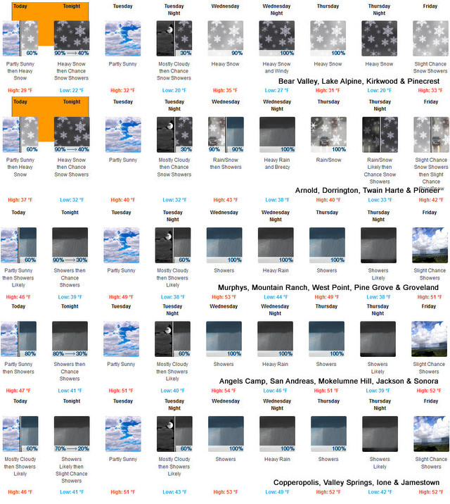
Arnold, CA…This is the detailed forecast for the West Slope Northern Sierra Nevada from the National Weather Service in Sacramento. Today, Mostly cloudy. A chance of snow showers late in the afternoon. Highs 25 to 40 higher elevations…36 to 46 lower elevations. Prevailing east winds up to 10 mph shifting to the south in the afternoon. Gusts up to 25 mph. Tonight, Heavy snow showers in the evening, then a chance of rain and snow showers after midnight. Lows 14 to 29 higher elevations…27 to 35 lower elevations. Snow accumulation 3 to 5 inches lower elevations…except 3 to 9 inches higher elevations. Snow level 4000 feet. Prevailing south winds up to 10 mph with gusts to around 25 mph.
Tuesday
Mostly cloudy. A slight chance of snow showers in the afternoon. Highs 26 to 41 higher elevations…37 to 47 lower elevations. Prevailing south winds up to 10 mph.
Tuesday Night
Mostly cloudy. A slight chance of snow showers in the evening. Lows 16 to 31 higher elevations…29 to 39 lower elevations. Prevailing southeast winds up to 10 mph.
Wednesday
A chance of rain and snow showers in the morning, then rain showers and heavy snow showers in the afternoon. Not as cool. Highs 31 to 46 higher elevations…43 to 51 lower elevations. Little or no snow accumulation lower elevations… 3 to 6 inches higher elevations. Snow level 5000 feet. Prevailing southeast winds up to 15 mph with gusts to around 30 mph.
Wednesday Night
Heavy rain showers and heavy snow showers. Windy. Heavy snow accumulations possible. Lows 26 to 41.
Thursday
Heavy rain and snow showers. Breezy. Heavy snow accumulations possible. Highs 30 to 45.
Thursday Night
Mostly cloudy with rain and snow showers likely. Colder. Moderate snow accumulations possible. Lows 21 to 36.
Friday And Friday Night
Mostly cloudy with a slight chance of rain and snow showers. Highs 32 to 47. Lows 21 to 36.
Saturday Through Sunday
Mostly cloudy with a chance of rain and snow showers. Highs 33 to 48. Lows 22 to 37.
Detailed forecast for
Motherlode
Today
Mostly cloudy. A chance of rain showers late in the afternoon. Highs 42 to 50. Prevailing southeast winds up to 10 mph.
Tonight
Cloudy. Rain showers and heavy snow showers in the evening, then a chance of rain showers after midnight. Lows 32 to 42. No snow accumulation lower elevations…up to 1 inch higher elevations. Prevailing southeast winds up to 10 mph.
Tuesday
Mostly cloudy. A slight chance of rain showers in the afternoon. Highs 43 to 53. Prevailing southeast winds up to 10 mph.
Tuesday Night
Mostly cloudy. A slight chance of rain showers in the evening. Lows 35 to 43. Light winds.
Wednesday
A chance of rain showers in the morning, then rain showers in the afternoon. Highs 49 to 57. Prevailing southeast winds up to 20 mph. Gusts up to 35 mph in the afternoon.
Wednesday Night
Heavy rain showers. Breezy. Lows 41 to 49.
Thursday
Rain showers and a slight chance of thunderstorms. Highs 44 to 54.
Thursday Night
Mostly cloudy with a chance of rain showers. Lows 36 to 44.
Friday And Friday Night
Mostly cloudy with a slight chance of rain showers. Highs 47 to 55. Lows 36 to 44.
Saturday Through Sunday
Mostly cloudy with a chance of rain showers. Highs 47 to 56. Lows 36 to 44.
Winter Weather Advisory
URGENT – WINTER WEATHER MESSAGE
National Weather Service Sacramento CA
303 AM PST Mon Jan 2 2023
CAZ068-069-030600-
/O.CON.KSTO.WW.Y.0001.230102T1800Z-230103T1200Z/
Western Plumas County/Lassen Park-
West Slope Northern Sierra Nevada-
Including the cities of Chester, Quincy, and Blue Canyon
303 AM PST Mon Jan 2 2023
…WINTER WEATHER ADVISORY REMAINS IN EFFECT FROM 10 AM THIS
MORNING TO 4 AM PST TUESDAY ABOVE 3000 FEET…
* WHAT…Snow expected. Total snow accumulations of 2 to 6 inches
above 3000 ft, 5 to 9 inches above 5000 ft.
* WHERE…Western Plumas County/Lassen Park and West Slope
Northern Sierra Nevada Counties, including Interstate 80 over
Donner Pass and Highway 50 over Echo Summit.
* WHEN…From 10 AM this morning to 4 AM PST Tuesday.
* IMPACTS…Travel could be very difficult. The hazardous
conditions could impact the evening commute.
PRECAUTIONARY/PREPAREDNESS ACTIONS…
Slow down and use caution while traveling.
The latest road conditions for the state you are calling from can
be obtained by calling 5 1 1.
A Winter Weather Returns with Kinder, Less Abusive Storms from Mother Nature added by admin on
View all posts by admin →