


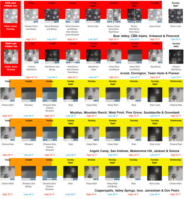
Arnold, CA…Detailed forecast for from the National Weather Service & Winter Storm Warning for the West Slope Northern Sierra Nevada. Tonight, Mostly clear. Lows 14 to 29 higher elevations…27 to 35 lower elevations. Prevailing south winds up to 15 mph. Gusts up to 30 mph after midnight. Sunday, At lower elevations, patchy dense fog in the morning, a chance of rain showers through the day. A chance of snow showers in the morning, then heavy snow showers likely in the afternoon. Highs 21 to 36 higher elevations…33 to 41 lower elevations. Snow accumulation 2 to 4 inches lower elevations…except 4 to 9 inches higher elevations. Prevailing south winds 5 to 15 mph with gusts to around 30 mph.
Sunday Night
Mostly cloudy in the evening then becoming partly cloudy. At higher elevations, a slight chance of snow showers in the evening. Windy, colder. Lows 4 to 19 higher elevations… 18 to 30 lower elevations. Little or no snow accumulation lower elevations…up to 1 inch higher elevations. Prevailing northeast winds 15 to 30 mph with gusts to around 50 mph.
Monday
Mostly sunny. Windy. Highs 19 to 34 higher elevations… 33 to 47 lower elevations. Prevailing northeast winds 15 to 30 mph with gusts to around 50 mph.
Monday Night
Clear, breezy. Lows 7 to 22 higher elevations… 22 to 31 lower elevations. Prevailing northeast winds 15 to 25 mph with gusts to around 45 mph.
Tuesday
Mostly sunny. Not as cool. Highs 34 to 49.
Tuesday Night
Mostly clear. Lows 18 to 33.
Wednesday
Mostly sunny. Not as cool. Highs 38 to 53.
Wednesday Night
Partly cloudy. Lows 21 to 36.
Thursday
Mostly cloudy. Highs 37 to 52.
Thursday Night
Mostly cloudy with a slight chance of rain and snow showers. Lows 23 to 38.
Friday
Mostly cloudy with a chance of rain and snow showers. Highs 32 to 47.
Friday Night
Mostly cloudy. Lows 21 to 36.
Saturday
Partly cloudy. Not as cool. Highs 38 to 53.
Detailed forecast for
Motherlode
Tonight
Mostly clear. Patchy fog in the late evening and early morning. Lows 32 to 40. Prevailing southeast winds up to 10 mph.
Sunday
Mostly cloudy. A chance of rain showers in the morning, then a chance of rain and snow showers in the afternoon. Highs 38 to 48. No snow accumulation lower elevations…up to 1 inch higher elevations. Prevailing southeast winds 5 to 15 mph.
Sunday Night
Mostly cloudy in the evening then clearing. Areas of frost after midnight. Colder. Lows 26 to 32. Prevailing northeast winds up to 15 mph with gusts to around 30 mph.
Monday
Widespread frost in the morning. Sunny. Highs 43 to 53. Prevailing northeast winds 5 to 15 mph with gusts to around 30 mph.
Monday Night
Clear. Lows 27 to 33. Prevailing northeast winds 5 to 15 mph with gusts to around 30 mph.
Tuesday
Sunny. Highs 46 to 54.
Tuesday Night
Mostly clear. Areas of frost. Lows 29 to 35.
Wednesday
Mostly sunny. Highs 50 to 56.
Wednesday Night
Partly cloudy. Lows 33 to 39.
Thursday
Mostly cloudy. Highs 50 to 58.
Thursday Night And Friday
Mostly cloudy with a chance of rain showers. Lows 38 to 44. Highs 46 to 56.
Friday Night And Saturday
Mostly cloudy. Lows 35 to 41. Highs 51 to 59.
Winter Weather Advisory
URGENT – WINTER WEATHER MESSAGE
National Weather Service Sacramento CA
112 PM PST Sat Jan 28 2023
CAZ068-069-291500-
/O.CON.KSTO.WW.Y.0006.230129T1200Z-230130T0300Z/
Western Plumas County/Lassen Park-
West Slope Northern Sierra Nevada-
Including the cities of Chester, Quincy, and Blue Canyon
112 PM PST Sat Jan 28 2023
…WINTER WEATHER ADVISORY REMAINS IN EFFECT FROM 4 AM TO 7 PM
PST SUNDAY…
* WHAT…Snow expected. Total snow accumulations 3 to 6 inches
at pass level. Winds gusting as high as 50 to 60 mph.
* WHERE…Western Plumas County/Lassen Park and West Slope
Northern Sierra Nevada Counties, including Interstate 80 over
Donner Pass, Highway 50 over Echo Summit.
* WHEN…From 4 AM to 7 PM PST Sunday.
* IMPACTS…Plan on slippery road conditions.
* ADDITIONAL DETAILS…Snow will likely impact weekend travelers
during the day on Sunday, especially mid day. Be sure to check
with CalTrans for the latest road conditions.
PRECAUTIONARY/PREPAREDNESS ACTIONS…
Slow down and use caution while traveling.
The latest road conditions for the state you are calling from can
be obtained by calling 5 1 1.
&&
$$
Wind Advisory
URGENT – WEATHER MESSAGE
National Weather Service Sacramento CA
1256 PM PST Sat Jan 28 2023
CAZ015>018-063-066-068-069-291500-
/O.CON.KSTO.WI.Y.0006.230129T2100Z-230130T2100Z/
Northern Sacramento Valley-Central Sacramento Valley-
Southern Sacramento Valley-Carquinez Strait and Delta-
Mountains Southwestern Shasta County to Western Colusa County-
Northeast Foothills/Sacramento Valley-
Western Plumas County/Lassen Park-
West Slope Northern Sierra Nevada-
Including the cities of Redding, Red Bluff, Chico, Oroville,
Marysville/Yuba City, Sacramento, Fairfield/Suisun,
Alder Springs, Paradise, Chester, Quincy, and Blue Canyon
1256 PM PST Sat Jan 28 2023
…WIND ADVISORY REMAINS IN EFFECT FROM 1 PM SUNDAY TO 1 PM PST
MONDAY…
* WHAT…North to northeast winds 20 to 30 mph with gusts 40 to
50 mph, with local gusts up to 60 mph in the mountains expected.
* WHERE…Portions of the Sacramento Valley, Carquinez Strait
and Delta, Mountains of Southwestern Shasta County to Western
Colusa County, Northeast Foothills/Sacramento Valley, Western
Plumas County/Lassen Park and West Slope Northern Sierra
Nevada Counties.
* WHEN…From 1 PM Sunday to 1 PM PST Monday.
* IMPACTS…Gusty winds could blow around unsecured objects.
Tree limbs could be blown down and a few power outages may
result.
* ADDITIONAL DETAILS…Strongest winds are expected over the
mountains, northeast foothills and the west side of the
Sacramento Valley.
PRECAUTIONARY/PREPAREDNESS ACTIONS…
Use extra caution when driving, especially if operating a high
profile vehicle. Secure outdoor objects.
&&
$$
Winter Storm Warning on Sunday as a Bit of Snow Heads to Our Way. added by admin on
View all posts by admin →