

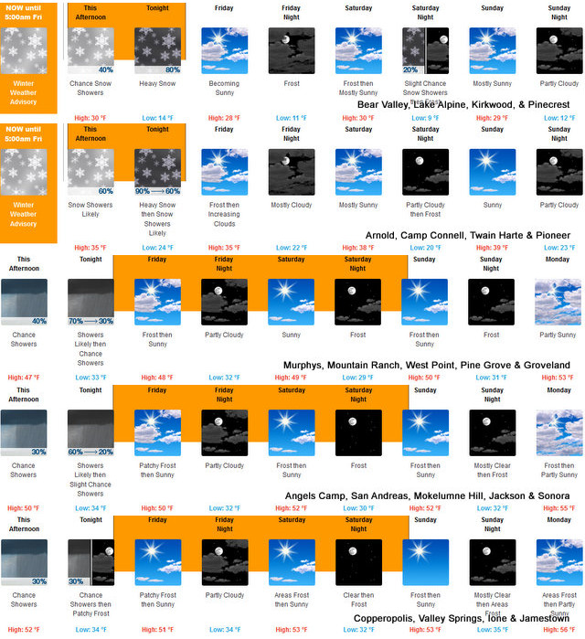
Arnold, CA…The National Weather Service in Sacramento has issued a Winter Weather Advisory until March 24 at 5am. Snow. Additional snow accumulations of 5 to 10 inches & Winds gusting as high as 40 mph. Snow level down to 3,500 feet & then clearing into the weekend.

Winter Weather Advisory
URGENT – WINTER WEATHER MESSAGE
National Weather Service Sacramento CA
134 PM PDT Thu Mar 23 2023
CAZ014-068-069-241200-
/O.CON.KSTO.WW.Y.0011.000000T0000Z-230324T1200Z/
Burney Basin / Eastern Shasta County-
Western Plumas County/Lassen Park-
West Slope Northern Sierra Nevada-
Including the cities of Burney, Chester, Quincy, and Blue Canyon
134 PM PDT Thu Mar 23 2023
…WINTER WEATHER ADVISORY REMAINS IN EFFECT UNTIL 5 AM PDT
FRIDAY…
* WHAT…Snow. Additional snow accumulations of 5 to 10 inches.
Winds gusting as high as 40 mph.
* WHERE…Burney Basin / Eastern Shasta County, Western Plumas
County/Lassen Park and West Slope Northern Sierra Nevada
Counties.
* WHEN…Until 5 AM PDT Friday.
* IMPACTS…Travel could be difficult at times, with possible
travel delays and chain controls.
* ADDITIONAL DETAILS…Snow levels will be between 4000 to 4500
feet lowering to around 3500 feet after midnight.
PRECAUTIONARY/PREPAREDNESS ACTIONS…
Slow down and use caution while traveling.
The latest road conditions for the state you are calling from can
be obtained by calling 5 1 1.
&&
$$
Frost Advisory
URGENT – WEATHER MESSAGE
National Weather Service Sacramento CA
100 PM PDT Thu Mar 23 2023
CAZ013-015>019-063-066-067-241200-
/O.CON.KSTO.FR.Y.0001.230324T1100Z-230326T1600Z/
Shasta Lake Area / Northern Shasta County-
Northern Sacramento Valley-Central Sacramento Valley-
Southern Sacramento Valley-Carquinez Strait and Delta-
Northern San Joaquin Valley-
Mountains Southwestern Shasta County to Western Colusa County-
Northeast Foothills/Sacramento Valley-Motherlode-
Including the cities of Shasta Dam, Redding, Red Bluff, Chico,
Oroville, Marysville/Yuba City, Sacramento, Fairfield/Suisun,
Stockton, Modesto, Alder Springs, Paradise, Grass Valley,
and Jackson
100 PM PDT Thu Mar 23 2023
…FROST ADVISORY REMAINS IN EFFECT FROM 4 AM FRIDAY TO 9 AM PDT
SUNDAY…
* WHAT…Temperatures as low as 28 to 36 will result in frost
formation.
* WHERE…Sacramento Valley, Northern San Joaquin Valley and
portions of the Carquinez Strait and Delta.
* WHEN…From 4 AM Friday to 9 AM PDT Sunday.
* IMPACTS…Frost could kill sensitive outdoor vegetation,
including early budding fruit trees, such as apricots, pears,
plums and peaches, if left uncovered.
* ADDITIONAL DETAILS…Morning frost will be possible each
morning from Friday to Sunday, with the coldest morning expected
Sunday.
PRECAUTIONARY/PREPAREDNESS ACTIONS…
Take steps now to protect tender plants from the cold.
&&
$$
Winter Weather Advisory Until Early Friday Morning. Then a Sunny Weekend Ahead! added by admin on
View all posts by admin →