

Arnold, CA…You know cliches are usually cliches for a reason right? Well they are this week as hot August Nights & Days await us this week That & the normal summer pattern of Thunderstorms in the high country. A heat advisory starts today and runs through Thursday. Detailed forecasts from the National Weather Service are below…

Detailed forecast for
West Slope Northern Sierra Nevada
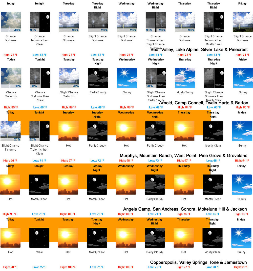
Today
Mostly cloudy. A chance of showers and thunderstorms in the afternoon. Highs 70 to 85 higher elevations…84 to 94 lower elevations. Prevailing east winds up to 10 mph shifting to the south in the afternoon.
Tonight
Mostly cloudy with a chance of showers and thunderstorms in the evening, then clear after midnight. Lows 50 to 65 higher elevations…60 to 75 lower elevations. Prevailing east winds up to 10 mph.
Tuesday
Sunny in the morning, then partly cloudy with a slight chance of showers and thunderstorms in the afternoon. Highs 71 to 86 higher elevations…87 to 97 lower elevations. Prevailing east winds up to 10 mph shifting to the southwest in the afternoon.
Tuesday Night
Partly cloudy with a slight chance of showers and thunderstorms. Lows 50 to 65 higher elevations…61 to 76 lower elevations. Prevailing northeast winds up to 15 mph.
Wednesday
Mostly sunny. A slight chance of showers and thunderstorms in the afternoon. Highs 71 to 86 higher elevations…87 to 97 lower elevations. Prevailing east winds up to 10 mph shifting to the southwest in the afternoon.
Wednesday Night
Mostly cloudy with a slight chance of showers and thunderstorms. Lows 55 to 70.
Thursday
Partly cloudy with a chance of rain showers and a slight chance of thunderstorms. Highs 74 to 89.
Thursday Night And Friday
Mostly clear. A slight chance of showers and thunderstorms. Lows 52 to 67. Highs 72 to 87.
Friday Night
Partly cloudy with a slight chance of rain showers. Cooler. Lows 49 to 64.
Saturday
Partly cloudy with a slight chance of showers and thunderstorms. Highs 69 to 84.
Saturday Night
Partly cloudy with a slight chance of rain showers. Lows 47 to 62.
Sunday
Partly cloudy with a slight chance of showers and thunderstorms. Highs 65 to 80.
Detailed forecast for
Motherlode
Today
Mostly cloudy in the morning, then partly cloudy with a slight chance of showers and thunderstorms in the afternoon. Highs 88 to 100. Prevailing east winds up to 10 mph shifting to the southwest in the afternoon.
Tonight
Mostly clear. A slight chance of showers and thunderstorms in the evening. Lows 67 to 77. Prevailing northeast winds up to 10 mph.
Tuesday
Sunny. Highs 93 to 103. Prevailing east winds up to 10 mph shifting to the southwest in the afternoon.
Tuesday Night
Mostly clear. Lows 69 to 77. Prevailing northeast winds up to 15 mph.
Wednesday
Mostly sunny. Highs 93 to 103. Prevailing east winds up to 10 mph shifting to the southwest in the afternoon.
Wednesday Night
Partly cloudy. Lows 69 to 77.
Thursday
Mostly sunny. Highs 90 to 100.
Thursday Night Through Friday Night
Mostly clear. Lows 60 to 72. Highs 85 to 100.
Saturday
Sunny. Highs 83 to 93.
Saturday Night And Sunday
Mostly clear. Lows 60 to 68. Highs 80 to 93.
Heat Advisory
URGENT – WEATHER MESSAGE
National Weather Service Sacramento CA
226 AM PDT Mon Aug 14 2023
CAZ015>017-019-063-066-067-150000-
/O.CON.KSTO.HT.Y.0004.230814T1800Z-230818T0600Z/
Northern Sacramento Valley-Central Sacramento Valley-
Southern Sacramento Valley-Northern San Joaquin Valley-
Mountains Southwestern Shasta County to Western Colusa County-
Northeast Foothills/Sacramento Valley-Motherlode-
Including the cities of Redding, Red Bluff, Chico, Oroville,
Marysville/Yuba City, Sacramento, Stockton, Modesto,
Alder Springs, Paradise, Grass Valley, and Jackson
226 AM PDT Mon Aug 14 2023
…HEAT ADVISORY REMAINS IN EFFECT FROM 11 AM THIS MORNING TO
11 PM PDT THURSDAY…
* WHAT…Temperatures up to 105 expected.
* WHERE…Sacramento and Northern San Joaquin Valleys, and the
lower elevations of Southwestern Shasta County to Western Colusa
County, Northeast Foothills/Sacramento Valley and Motherlode
Counties.
* WHEN…From 11 AM this morning to 11 PM PDT Thursday.
* IMPACTS…Hot temperatures may cause heat illnesses to occur.
* ADDITIONAL DETAILS…Hottest days will be Tuesday and Wednesday,
with widespread Moderate Heat Risk across the Valley and
Foothills, and areas of Major Heat Risk in the Valley on
Tuesday. Warm overnight temperatures will bring little relief.
PRECAUTIONARY/PREPAREDNESS ACTIONS…
Drink plenty of fluids, stay in an air-conditioned room, stay out
of the sun, and check up on relatives and neighbors. Young
children and pets should never be left unattended in vehicles
under any circumstances.
Take extra precautions if you work or spend time outside. When
possible reschedule strenuous activities to early morning or
evening. Know the signs and symptoms of heat exhaustion and heat
stroke. Wear lightweight and loose fitting clothing when
possible. To reduce risk during outdoor work, the Occupational
Safety and Health Administration recommends scheduling frequent
rest breaks in shaded or air conditioned environments. Anyone
overcome by heat should be moved to a cool and shaded location.
Heat stroke is an emergency! Call 9 1 1.
&&
Hot August Days & Nights with Thunderstorms in the High Country Await Us this Week added by admin on
View all posts by admin →