

Arnold, CA…Ladies, Gents, Boys & Girls…the Calendar may say it’s still September but there is actually a chance of snow in the high country. Detailed forecasts from the National Weather Service for the West Slope & Mother Lode are below. Enjoy…

Detailed forecast for
West Slope Northern Sierra Nevada
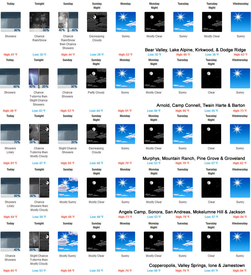
Today
Mostly cloudy. At higher elevations, a chance of rain showers, snow showers and a slight chance of thunderstorms in the morning, then rain showers, a chance of thunderstorms and snow showers in the afternoon. At lower elevations, a chance of rain showers and a slight chance of thunderstorms in the morning, then a chance of thunderstorms early in the afternoon. Rain showers likely in the afternoon. A slight chance of thunderstorms late in the afternoon. Highs 37 to 52 higher elevations…49 to 59 lower elevations. No snow accumulation. Snow level above 8000 feet. Prevailing south winds up to 15 mph.
Tonight
Mostly cloudy. At lower elevations, a chance of rain showers and a slight chance of thunderstorms in the evening, then a slight chance of rain showers after midnight. At higher elevations, a chance of rain showers, snow showers likely and a chance of thunderstorms in the evening, then a chance of rain and snow showers after midnight. Colder. Lows 28 to 43 higher elevations…37 to 49 lower elevations. Snow level above 8000 feet. Prevailing northwest winds up to 10 mph.
Sunday
Mostly cloudy. At higher elevations, a chance of rain and snow showers in the morning, then a chance of rain showers in the afternoon. At lower elevations, a slight chance of rain showers in the afternoon. Not as cool. Highs 41 to 56 higher elevations…54 to 66 lower elevations. Snow level above 8000 feet. Prevailing north winds up to 10 mph shifting to the northwest in the afternoon.
Sunday Night
Mostly cloudy in the evening then clearing. Lows 27 to 42 higher elevations…38 to 51 lower elevations. Prevailing northwest winds up to 10 mph shifting to the northeast after midnight.
Monday
Mostly sunny. Warmer. Highs 49 to 64 higher elevations…62 to 72 lower elevations. Prevailing northeast winds up to 10 mph shifting to the northwest in the afternoon.
Monday Night
Mostly clear. Lows 36 to 51.
Tuesday
Sunny, warmer. Highs 60 to 75.
Tuesday Night Through Friday
Clear. Lows 43 to 58. Highs 63 to 78.
Detailed forecast for
Motherlode
Today
Mostly cloudy. A chance of rain showers and a slight chance of thunderstorms in the morning, then rain showers likely and a slight chance of thunderstorms in the afternoon. Highs 55 to 67. Prevailing south winds up to 10 mph.
Tonight
Mostly cloudy. A slight chance of showers and thunderstorms in the evening. Lows 44 to 54. Light winds.
Sunday
Partly cloudy in the morning then becoming mostly sunny. Warmer. Highs 60 to 72. Light winds becoming west up to 10 mph in the afternoon.
Sunday Night
Mostly clear. Lows 44 to 54. Prevailing northwest winds up to 10 mph shifting to the northeast after midnight.
Monday
Sunny, warmer. Highs 66 to 78. Prevailing northeast winds up to 10 mph shifting to the west in the afternoon.
Monday Night
Mostly clear. Lows 49 to 57.
Tuesday
Sunny, warmer. Highs 72 to 84.
Tuesday Night Through Friday
Clear. Lows 54 to 65. Highs 73 to 88.
It’s Sept. 30 & Wax Those Skis! Chance of Snow Showers in the High Country added by admin on
View all posts by admin →