

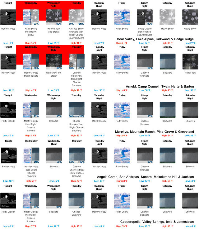
Arnold, CA…Heavy snow expected. Total snow accumulations of up to 2 feet above 6000 feet. Total snow accumulations of 6 to 12 inches between 5000 and 6000 feet. Winds gusting as high as 45 mph.

Winter Storm Warning
URGENT – WINTER WEATHER MESSAGE
National Weather Service Sacramento CA
1229 PM PST Tue Feb 13 2024
CAZ068-069-140430-
/O.NEW.KSTO.WS.W.0008.240214T1200Z-240216T0000Z/
Western Plumas County/Lassen Park-
West Slope Northern Sierra Nevada-
Including the cities of Chester, Quincy, and Blue Canyon
1229 PM PST Tue Feb 13 2024
…WINTER STORM WARNING IN EFFECT FROM 4 AM WEDNESDAY TO 4 PM PST
THURSDAY…
* WHAT…Heavy snow expected. Total snow accumulations of up to 2
feet above 6000 feet. Total snow accumulations of 6 to 12 inches
between 5000 and 6000 feet. Winds gusting as high as 45 mph.
* WHERE…Western Plumas County/Lassen Park and West Slope
Northern Sierra Nevada, including Interstate 80 and Highway 50.
* WHEN…From 4 AM Wednesday to 4 PM PST Thursday.
* IMPACTS…Travel could be very difficult to impossible. The
hazardous conditions could impact the morning or evening
commute. Gusty winds could bring down tree branches.
* ADDITIONAL DETAILS…Snow levels expected to begin around 5000
to 6000 feet on Wednesday, lowering to 4500 to 5500 feet
overnight into Thursday. Heaviest snow accumulations are
anticipated Wednesday evening into Thursday, with snow rates of
1 to 2 inches per hour at times.
PRECAUTIONARY/PREPAREDNESS ACTIONS…
If you must travel, keep an extra flashlight, food, and water in
your vehicle in case of an emergency.
The latest road conditions for the state you are calling from can
be obtained by calling 5 1 1.
&&
Another Weather System Heading Our Way Bringing Up to 2 Feet of Snow to the High Country added by admin on
View all posts by admin →