

Arnold, CA…The first string days with excessive heat warnings are in our future this week. It is also a nice time to remind people what a great area we live in because we have rapid elevation changes within just few minutes of travel time. Typically you can see a 20 – 25 degree change from the high country to the foothills. So if triple digits make you sweat then dipping your toes in Silver Lake, Lake Alpine or Pinecrest might be just the plan for you.

Detailed forecast for
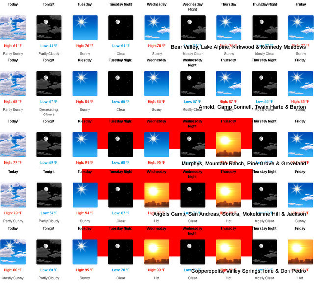
West Slope Northern Sierra Nevada
Today
Mostly cloudy. At higher elevations, a slight chance of rain showers in the afternoon. Highs 54 to 69 higher elevations… 65 to 77 lower elevations. Prevailing southwest winds up to 15 mph with gusts to around 30 mph…except southwest up to 25 mph over ridges.
Tonight
Mostly cloudy in the evening then clearing. Lows 40 to 55 higher elevations…51 to 63 lower elevations. Prevailing west winds up to 10 mph shifting to the northeast after midnight. Gusts up to 25 mph.
Tuesday
Sunny, warmer. Highs 70 to 85 higher elevations… 82 to 92 lower elevations. Prevailing northeast winds up to 10 mph shifting to the north in the afternoon.
Tuesday Night
Clear. Lows 48 to 63 higher elevations…59 to 71 lower elevations. Prevailing northwest winds up to 10 mph shifting to the northeast after midnight.
Wednesday
Sunny, warmer. Highs 73 to 88 higher elevations… 85 to 95 lower elevations. Prevailing east winds up to 10 mph shifting to the west in the afternoon.
Wednesday Night
Mostly clear. Lows 54 to 69.
Thursday
Sunny. Highs 77 to 92.
Thursday Night Through Saturday
Mostly clear. Lows 52 to 67. Highs 75 to 90.
Saturday Night
Partly cloudy. Lows 50 to 65.
Sunday
Mostly sunny. Highs 70 to 85.
Detailed forecast for
Motherlode
Today
Mostly cloudy. Highs 72 to 84. Prevailing southwest winds up to 15 mph.
Tonight
Mostly clear. Lows 56 to 62. Prevailing west winds up to 10 mph in the evening becoming light.
Tuesday
Sunny, warmer. Highs 87 to 99. Prevailing north winds up to 10 mph shifting to the northwest in the afternoon. Gusts up to 25 mph.
Tuesday Night
Clear. Lows 65 to 71. Prevailing northwest winds up to 10 mph with gusts to around 25 mph in the evening becoming light.
Wednesday
Sunny. Highs 90 to 102. Light winds becoming west up to 10 mph in the afternoon.
Wednesday Night
Clear. Lows 66 to 74.
Thursday
Sunny. Highs 91 to 101.
Thursday Night
Mostly clear. Lows 64 to 72.
Friday
Sunny. Highs 89 to 99.
Friday Night And Saturday
Mostly clear. Lows 60 to 68. Highs 85 to 99.
Saturday Night
Partly cloudy. Lows 60 to 66.
Sunday
Mostly sunny. Highs 83 to 93.
Excessive Heat Warning
URGENT – WEATHER MESSAGE
National Weather Service Sacramento CA
109 AM PDT Mon Jun 3 2024
CAZ013-015>019-063-066-067-040015-
/O.CON.KSTO.EH.W.0001.240604T1800Z-240607T0300Z/
Shasta Lake Area / Northern Shasta County-Northern Sacramento
Valley-Central Sacramento Valley-Southern Sacramento Valley-
Carquinez Strait and Delta-Northern San Joaquin Valley-Mountains
Southwestern Shasta County to Western Colusa County-Northeast
Foothills/Sacramento Valley-Motherlode-
Including the cities of Fairfield/Suisun, Alder Springs,
Stockton, Grass Valley, Chico, Oroville, Jackson, Modesto, Shasta
Dam, Redding, Marysville/Yuba City, Red Bluff, Paradise, and
Sacramento
109 AM PDT Mon Jun 3 2024
…EXCESSIVE HEAT WARNING REMAINS IN EFFECT FROM 11 AM TUESDAY TO 8
PM PDT THURSDAY…
* WHAT…Dangerously hot conditions with temperatures 95 to 108
possible and widespread Major HeatRisk. Limited overnight relief
with low temperatures in the 60s to mid 70s.
* WHERE…Carquinez Strait and Delta, Sacramento Valley, Motherlode,
Mountains Southwestern Shasta County to Western Colusa County,
Northeast Foothills, Northern San Joaquin Valley, and portions of
Shasta County.
* WHEN…From 11 AM Tuesday to 8 PM PDT Thursday.
* IMPACTS…Heat related illnesses increase significantly during
extreme heat events, particularly for those working or
participating in outdoor activities.
* ADDITIONAL DETAILS…Hottest temperatures are expected Wednesday.
Area waterways will continue to run cold and fast, creating
dangerous conditions for those seeking relief in rivers and lakes.
Hot temperatures may linger into Friday.
PRECAUTIONARY/PREPAREDNESS ACTIONS…
Drink plenty of fluids, stay in an air-conditioned room, stay out of
the sun, and check up on relatives and neighbors.
Do not leave young children and pets in unattended vehicles. Car
interiors will reach lethal temperatures in a matter of minutes.
Monitor the latest forecasts and warnings for updates.
&&
$$
For more information, visit us at www.weather.gov/sto/
The Heat is On! 2024’s First Heat Warnings Starting Tomorrow! Head for the Lake or High Country! added by admin on
View all posts by admin →