

Arnold, CA…The Heat is on for the next few days for the West Slope & Mother Lode with a heat advisory for lower elevations till 8pm tonight. Detailed forecasts from the National Weather Service are below…

Detailed forecast for
West Slope Northern Sierra Nevada
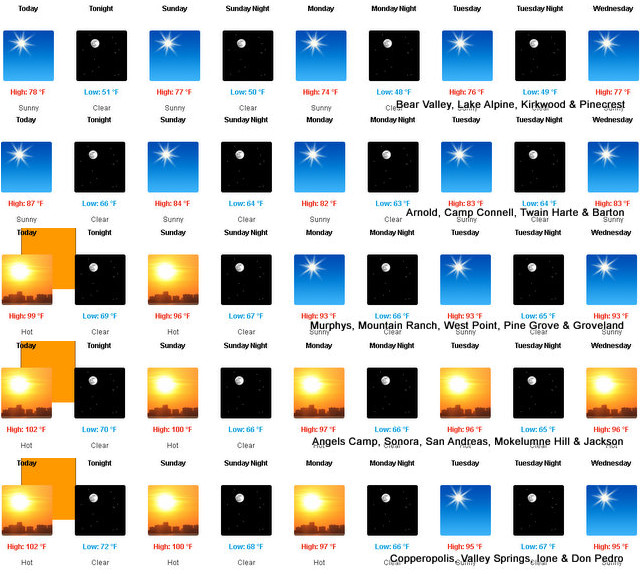
Today
Sunny. Highs 73 to 88 higher elevations…87 to 97 lower elevations. Prevailing southeast winds up to 10 mph shifting to the southwest in the afternoon. Gusts up to 25 mph.
Tonight
Clear. Lows 49 to 64 higher elevations…60 to 73 lower elevations. Prevailing southwest winds up to 10 mph with gusts to around 25 mph in the evening becoming light.
Sunday
Sunny. Highs 70 to 85 higher elevations…84 to 94 lower elevations. Prevailing southeast winds up to 10 mph shifting to the southwest with gusts to around 30 mph in the afternoon.
Sunday Night
Clear. Lows 47 to 62 higher elevations…58 to 70 lower elevations. Prevailing southwest winds up to 10 mph with gusts to around 30 mph in the evening becoming light.
Monday
Sunny. Highs 68 to 83 higher elevations…82 to 92 lower elevations. Prevailing southeast winds up to 10 mph shifting to the southwest with gusts to around 30 mph in the afternoon.
Monday Night
Clear. Lows 50 to 65.
Tuesday
Sunny. Highs 74 to 89.
Tuesday Night Through Wednesday Night
Clear. Lows 49 to 64. Highs 74 to 89.
Thursday Through Friday
Clear. Highs 70 to 85. Lows 47 to 62.
Detailed forecast for
Motherlode
Today
Sunny, warmer. Highs 90 to 100 higher elevations…97 to 105 lower elevations. Light winds becoming southwest up to 10 mph in the afternoon.
Tonight
Clear. Lows 65 to 73. Light winds.
Sunday
Sunny. Highs 89 to 103. Light winds becoming southwest up to 10 mph in the afternoon.
Sunday Night
Clear. Lows 62 to 70. Prevailing southwest winds up to 10 mph in the evening becoming light.
Monday
Sunny. Highs 87 to 99. Light winds becoming southwest up to 10 mph in the afternoon.
Monday Night
Clear. Lows 60 to 69.
Tuesday
Sunny. Highs 87 to 99.
Tuesday Night Through Wednesday Night
Clear. Lows 59 to 69. Highs 87 to 99.
Thursday Through Friday
Clear. Highs 82 to 95. Lows 56 to 67.
Heat Advisory
URGENT – WEATHER MESSAGE
National Weather Service Sacramento CA
1247 AM PDT Sat Jun 22 2024
CAZ015>017-019-067-230000-
/O.CON.KSTO.HT.Y.0002.240622T1800Z-240623T0300Z/
Northern Sacramento Valley-Central Sacramento Valley-
Southern Sacramento Valley-Northern San Joaquin Valley-Motherlode-
Including the cities of Redding, Red Bluff, Chico, Oroville,
Marysville/Yuba City, Sacramento, Stockton, Modesto,
Grass Valley, and Jackson
1247 AM PDT Sat Jun 22 2024
…HEAT ADVISORY REMAINS IN EFFECT FROM 11 AM THIS MORNING TO
8 PM PDT THIS EVENING…
* WHAT…High temperatures 100 to 107 expected. Limited
overnight relief with low temperatures in the mid 60s to mid
70s.
* WHERE…Central Sacramento Valley, Motherlode, Northern
Sacramento Valley, Northern San Joaquin Valley, and eastern
side of the Southern Sacramento Valley.
* WHEN…From 11 AM to 8 PM PDT Saturday.
* IMPACTS…Hot temperatures may cause heat illnesses.
* ADDITIONAL DETAILS…Widespread Moderate HeatRisk with areas
of Major HeatRisk expected. Warmest lows in the northern and
central Sacramento Valley and foothills.
PRECAUTIONARY/PREPAREDNESS ACTIONS…
Drink plenty of fluids, stay in an air-conditioned room, stay out
of the sun, and check up on relatives and neighbors.
Heat Advisory for Lower Elevations Today and a Warm Week Ahead for West Slope & Mother Lode! added by admin on
View all posts by admin →