

Arnold, CA…Well, our normal February weather that became Marchuary now looks like it will be Apriluary as well.
The winter storm warning was moved up from 11pm this evening to 5pm this afternoon. We may also see wind gust to 60 mph as well. Forecast for the West Slope & Mother Lode and the storm warning are below…
ThePineTree.net Weather Sponsored By Fox Security

Detailed forecast for
West Slope Northern Sierra Nevada
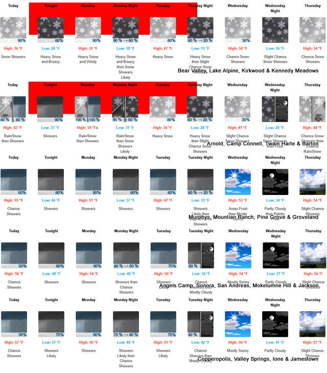
Today
At lower elevations, rain and snow showers early in the morning, then rain showers in the late morning and afternoon. At higher elevations, heavy snow showers early in the morning, then rain and snow showers in the late morning and afternoon. Highs 31 to 46 higher elevations…41 to 53 lower elevations. No snow accumulation lower elevations…3 to 6 inches higher elevations. Snow level 5500 feet increasing to 7000 feet in the afternoon. Prevailing south winds 10 to 20 mph with gusts to around 50 mph. Over ridges, prevailing southwest winds 15 to 30 mph increasing to 25 to 40 mph in the afternoon. Gusts up to 55 mph over ridges.
Tonight
At lower elevations, rain showers and a slight chance of thunderstorms in the evening, then rain showers after midnight. At higher elevations, rain showers, snow showers and a slight chance of thunderstorms in the evening, then heavy rain and snow showers after midnight. Breezy. Lows 23 to 37 higher elevations…34 to 44 lower elevations. No snow accumulation lower elevations…1 to 7 inches higher elevations. Snow level 7000 feet. Prevailing southwest winds 10 to 25 mph with gusts to around 60 mph…except southwest 10 to 50 mph over ridges.
Monday
Heavy rain and snow showers in the morning, then heavy snow showers, rain showers and a slight chance of thunderstorms in the afternoon. Breezy. Highs 26 to 41 higher elevations… 37 to 49 lower elevations. No snow accumulation lower elevations…7 to 12 inches higher elevations. Snow level 5500 feet. Prevailing southwest winds 15 to 25 mph with gusts to around 60 mph…except southwest 15 to 45 mph with gusts to around 65 mph over ridges.
Monday Night
Heavy snow showers, rain showers and a slight chance of thunderstorms in the evening, then snow showers likely after midnight. Colder. Lows 16 to 31 higher elevations…29 to 37 lower elevations. Snow accumulation up to 2 inches lower elevations…except 3 to 9 inches higher elevations. Snow level 4500 feet. Prevailing southwest winds up to 20 mph. Gusts up to 60 mph decreasing to 35 mph after midnight. Over ridges… Prevailing southwest winds 30 to 40 mph decreasing to 15 to 30 mph after midnight.
Tuesday
Heavy snow showers likely in the morning, then heavy rain and snow showers in the afternoon. Highs 23 to 38 higher elevations…35 to 45 lower elevations. Snow accumulation of 2 to 7 inches lower elevations…except 7 to 12 inches higher elevations. Snow level 3500 feet. Prevailing southwest winds up to 15 mph with gusts to around 35 mph…except southwest up to 25 mph over ridges.
Tuesday Night
Mostly cloudy with rain and snow showers likely. Moderate snow accumulations possible. Lows 17 to 32.
Wednesday
Partly cloudy with a chance of snow showers. Widespread frost. Not as cool. Highs 33 to 48.
Wednesday Night Through Thursday Night
Mostly cloudy with a chance of rain and snow showers. Lows 19 to 34. Highs 34 to 49.
Friday
Partly cloudy with a chance of rain and snow showers. Not as cool. Highs 38 to 53.
Friday Night
Partly cloudy with a slight chance of snow showers. Lows 24 to 39.
Saturday
Mostly sunny. Not as cool. Highs 43 to 58.
Detailed forecast for
Motherlode
Today
Rain showers early in the morning, then a chance of rain showers in the late morning and afternoon. Highs 48 to 60. Prevailing southeast winds 5 to 15 mph with gusts to around 35 mph.
Tonight
Rain showers and a slight chance of thunderstorms in the evening, then rain showers after midnight. Lows 40 to 50. Prevailing south winds 5 to 15 mph with gusts to around 35 mph.
Monday
Rain showers in the morning, then rain showers and a slight chance of thunderstorms in the afternoon. Highs 43 to 53 higher elevations…50 to 58 lower elevations. Prevailing southwest winds 5 to 15 mph with gusts to around 30 mph.
Monday Night
Rain showers and a slight chance of thunderstorms in the evening, then rain showers likely after midnight. Colder. Lows 34 to 44. Prevailing southwest winds up to 10 mph with gusts to around 25 mph.
Tuesday
Mostly cloudy. Rain and snow showers likely in the morning, then rain showers in the afternoon. Highs 41 to 53. No snow accumulation. Prevailing south winds up to 10 mph.
Tuesday Night
Mostly cloudy with a slight chance of showers and thunderstorms. Lows 31 to 41.
Wednesday
Partly cloudy with a slight chance of rain showers. Not as cool. Highs 47 to 59.
Wednesday Night And Thursday
Partly cloudy with a slight chance of rain showers. Lows 31 to 41. Highs 47 to 60.
Thursday Night
Partly cloudy with a chance of rain showers. Lows 35 to 41.
Friday
Partly cloudy with a slight chance of rain showers. Highs 54 to 64.
Friday Night And Saturday
Mostly clear. Lows 38 to 44. Highs 55 to 70.
Winter Storm Warning
URGENT – WINTER WEATHER MESSAGE
National Weather Service Sacramento CA
149 AM PDT Sun Mar 30 2025
CAZ068-069-310000-
/O.CON.KSTO.WS.W.0009.250331T0000Z-250402T0600Z/
Western Plumas County/Lassen Park-West Slope Northern Sierra
Nevada-
Including the cities of Chester, Quincy, and Blue Canyon
149 AM PDT Sun Mar 30 2025
…WINTER STORM WARNING REMAINS IN EFFECT FROM 5 PM THIS AFTERNOON
TO 11 PM PDT TUESDAY ABOVE 4000 FEET…
* WHAT…Heavy snow possible above 4000 feet. Total snow
accumulations 1 to 4 feet possible, locally up to 5 feet over
peaks. Winds could gust as high as 65 mph.
* WHERE…West Slope Northern Sierra Nevada and Western Plumas
County/Lassen Park Counties.
* WHEN…From 5 PM this afternoon to 11 PM PDT Tuesday.
* IMPACTS…Travel could be very difficult to impossible. The
hazardous conditions could impact the Monday morning and evening
commutes. Strong winds could cause tree damage.
* ADDITIONAL DETAILS…Heaviest snowfall expected Monday, with
snowfall rates up to 2 inches an hour. Snow levels fall to around
3000 feet by early Tuesday. Light snowfall accumulations of 1 to 6
inches are possible down to 3000 feet.
PRECAUTIONARY/PREPAREDNESS ACTIONS…
Check the latest road conditions from Caltrans online at
quickmap.dot.ca.gov or dial 5 1 1.
Persons should delay travel if possible. If travel is absolutely
necessary, drive with extreme caution and be prepared for sudden
changes in visibility. Consider taking a winter storm kit along with
you and anything else that would help you survive in case you become
stranded.
&&
$$
For more information, visit us at www.weather.gov/sto/
EK
Winter Storm Warning Starting at 5pm & Up to 5 Feet of New Snow at Higher Elevations added by admin on
View all posts by admin →