

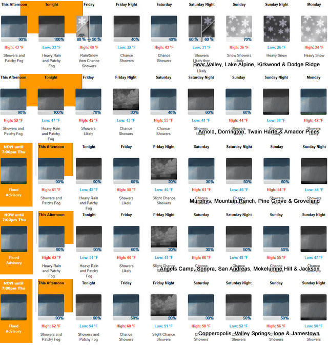
Arnold, CA…The forecasts from the NWS for the West Slope & Mother Lode are below. Winter has arrived with a vengeance. Snow on tap for weekend & early next week. Stay Safe, Stay Dry & Stay Warm…

ThePineTree.net Weather Sponsored By Fox Security
Detailed forecast for
West Slope Northern Sierra Nevada
Today
A slight chance of rain showers early in the morning, then rain showers in the late morning and afternoon. At lower elevations, patchy fog in the late morning and early afternoon. Areas of fog late in the afternoon. At higher elevations, patchy fog early in the afternoon. Areas of fog late in the afternoon. Highs 40 to 55 higher elevations…51 to 61 lower elevations. Prevailing south winds 10 to 20 mph with gusts to around 45 mph… Except south 10 to 30 mph with gusts to around 45 mph over ridges.
Tonight
Heavy rain showers. Patchy fog. Colder. Lows 28 to 42 higher elevations…39 to 49 lower elevations. Prevailing south winds up to 15 mph with gusts to around 35 mph.
Friday
Mostly cloudy. At lower elevations, rain showers likely in the morning, then a chance of rain showers in the afternoon. At higher elevations, rain showers likely and heavy snow showers in the morning, then rain and snow showers likely in the afternoon. Highs 37 to 52 higher elevations…49 to 59 lower elevations. No snow accumulation lower elevations…3 to 5 inches higher elevations. Snow level above 8000 feet. Prevailing southeast winds up to 10 mph.
Friday Night
Mostly cloudy in the evening then becoming partly cloudy. A slight chance of rain showers. Lows 29 to 44 higher elevations…39 to 49 lower elevations. Snow level above 8000 feet. Prevailing east winds up to 10 mph.
Saturday
Mostly cloudy. A slight chance of rain showers in the morning, then a chance of rain showers in the afternoon. Not as cool. Highs 41 to 56 higher elevations…55 to 65 lower elevations. Prevailing northeast winds up to 10 mph.
Saturday Night
Mostly cloudy with a chance of rain showers. Lows 31 to 46.
Sunday
Rain and snow showers likely. Light snow accumulations possible. Highs 35 to 50.
Sunday Night And Monday
Rain showers and heavy snow showers likely. Moderate snow accumulations possible. Lows 27 to 42. Highs 33 to 48.
Monday Night
Mostly cloudy with a chance of rain and snow showers. Colder. Lows 22 to 37.
Tuesday
Partly cloudy with a slight chance of rain and snow showers. Highs 35 to 50.
Tuesday Night
Mostly clear. Lows 22 to 37.
Wednesday
Partly cloudy with a chance of rain and snow showers. Highs 37 to 52.
Detailed forecast for
Motherlode
Today
A slight chance of rain showers early in the morning, then rain showers in the late morning and afternoon. Patchy fog in the late morning and afternoon. Highs 56 to 66. Prevailing south winds 10 to 20 mph with gusts to around 35 mph.
Tonight
Heavy rain showers and a slight chance of thunderstorms in the evening, then rain showers after midnight. Patchy fog through the night. Colder. Lows 42 to 54. Prevailing southeast winds up to 10 mph.
Friday
Mostly cloudy with a chance of rain showers. Highs 53 to 63. Light winds.
Friday Night
Partly cloudy with a slight chance of rain showers. Lows 43 to 51. Light winds.
Saturday
Partly cloudy with a slight chance of rain showers in the morning, then mostly cloudy with a chance of rain showers in the afternoon. Highs 56 to 68. Light winds.
Saturday Night
Mostly cloudy with a chance of rain showers. Lows 44 to 52.
Sunday
Mostly cloudy with a chance of rain showers. Highs 48 to 58.
Sunday Night And Monday
Mostly cloudy with rain showers likely. Lows 41 to 51. Highs 46 to 56.
Monday Night
Mostly cloudy with a chance of rain showers. Colder. Lows 35 to 45.
Tuesday
Partly cloudy with a slight chance of rain showers. Highs 49 to 59.
Tuesday Night
Mostly clear. Lows 35 to 43.
Wednesday
Partly cloudy with a slight chance of rain showers. Highs 49 to 57.
Winter Weather Advisory
URGENT – WINTER WEATHER MESSAGE
National Weather Service Sacramento CA
1131 AM PST Thu Nov 13 2025
CAZ069-141800-
/O.EXT.KSTO.WW.Y.0008.251114T0000Z-251114T1800Z/
West Slope Northern Sierra Nevada-
Including the cities of Blue Canyon
1131 AM PST Thu Nov 13 2025
…WINTER WEATHER ADVISORY NOW IN EFFECT FROM 4 PM THIS AFTERNOON TO
10 AM PST FRIDAY…
* WHAT…Wet snow expected above 7000 feet. Total snow accumulations
of 3 to 6 inches south of Highway 50 with 12 to 18 inches at the
highest peaks. Winds gusting as high as 50 mph.
* WHERE…West Slope Northern Sierra Nevada above 7000 feet.
* WHEN…From 4 PM this afternoon to 10 AM PST Friday.
* IMPACTS…The hazardous conditions could impact the Thursday
evening and Friday morning commutes.
* ADDITIONAL DETAILS…Snow levels above 8000 feet through Thursday
night, then lowering to around 7000-7500 feet by Friday morning.
PRECAUTIONARY/PREPAREDNESS ACTIONS…
Check the latest road conditions from Caltrans online at
quickmap.dot.ca.gov or dial 5 1 1.
&&
$$
For more information, visit us at www.weather.gov/sto/
IDS
Flood Advisory
Flood Advisory
National Weather Service Sacramento CA
1038 AM PST Thu Nov 13 2025
CAC005-007-009-011-017-021-057-061-067-077-095-099-101-103-109-113-
115-140300-
/O.NEW.KSTO.FA.Y.0012.251113T1838Z-251114T0300Z/
/00000.N.ER.000000T0000Z.000000T0000Z.000000T0000Z.OO/
Amador CA-Butte CA-Calaveras CA-Colusa CA-El Dorado CA-Glenn CA-
Nevada CA-Placer CA-Sacramento CA-San Joaquin CA-Solano CA-
Stanislaus CA-Sutter CA-Tehama CA-Tuolumne CA-Yolo CA-Yuba CA-
1038 AM PST Thu Nov 13 2025
…FLOOD ADVISORY IN EFFECT UNTIL 7 PM PST THIS EVENING…
* WHAT…Urban and small stream flooding caused by excessive
rainfall is expected.
* WHERE…Portions of interior northern California, including the
following counties, Placer, Amador, Butte, Calaveras, Colusa, El
Dorado, Glenn, Nevada, Sacramento, San Joaquin, Solano,
Stanislaus, Sutter, Tehama, Tuolumne, Yolo and Yuba.
* WHEN…Until 700 PM PST Thursday.
* IMPACTS…Minor flooding in low-lying and poor drainage areas.
Ponding of water in urban or other areas is occurring or is
imminent.
* ADDITIONAL DETAILS…
– At 1030 AM PST, Doppler radar indicated moderate to locally
heavy rain. This is causing urban and small stream flooding.
Between 0.5 and 1 inch of rain has fallen.
– Additional rainfall amounts of 1 to 3 inches are expected
over the area, highest amounts in the foothills. This
additional rain will result in minor flooding. California
Highway Patrol has reported roadway flooding in the area.
– Some locations that will experience flooding include…
Sacramento, Stockton, Modesto, Elk Grove, Roseville,
Fairfield, Vacaville, Chico, Citrus Heights, Folsom, Turlock,
Davis, Rocklin, Woodland, Ceres, Paradise, Galt, Oakdale,
Oroville and Auburn.
– http://www.weather.gov/safety/flood
PRECAUTIONARY/PREPAREDNESS ACTIONS…
Turn around, don`t drown when encountering flooded roads. Most flood
deaths occur in vehicles.
&&
LAT…LON 3979 12209 3995 12159 3957 12118 3786 12009
3733 12113 3820 12161 3812 12196 3828 12209
3833 12206 3843 12213 3851 12210 3869 12221
3961 12248
Winter Has Fully Arrived, Winter Weather Advisory & Flood Watches as Well. ~ Weather Sponsored by Fox Security added by admin on
View all posts by admin →