


Arnold, CA…Rest Of Tonight Mostly cloudy. Scattered rain and snow showers after midnight. Lows 19 to 34 higher elevations…30 to 40 lower elevations. Little or no new snow accumulation lower elevations… Except new snow accumulation up to 1 inch higher elevations. Snow level 3500 feet after midnight. Prevailing southeast winds up to 15 mph. Gusts up to 35 mph after midnight. Saturday At lower elevations, widespread heavy rain showers and heavy snow showers in the morning, then heavy rain in the afternoon. At higher elevations, widespread snow showers and heavy rain showers in the morning, then heavy rain and snow in the afternoon. Breezy. Not as cool. Highs 33 to 47 higher elevations…43 to 51 lower elevations. No snow accumulation lower elevations…4 to 9 inches higher elevations. Snow level 6000 feet increasing to 7000 feet in the afternoon. Prevailing south winds 15 to 25 mph with gusts to around 45 mph…except south 25 to 45 mph over ridges.
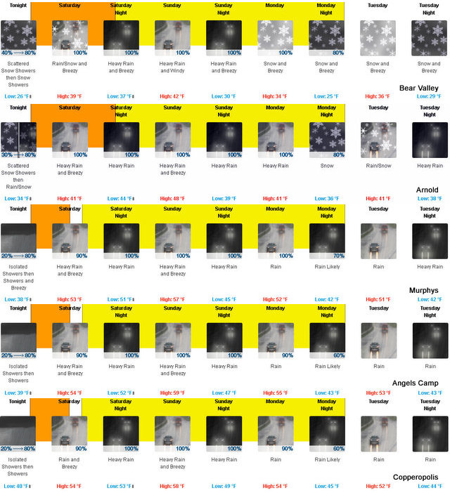
Saturday Night At lower elevations, heavy rain. At higher elevations, rain and snow in the evening, then heavy rain after midnight. Lows 30 to 42 higher elevations…39 to 47 lower elevations. Snow accumulation up to 3 inches. Snow level above 8000 feet. Prevailing south winds 10 to 20 mph with gusts to around 40 mph.
Sunday Heavy rain. Windy. Not as cool. Highs 35 to 49 higher elevations…47 to 55 lower elevations. Prevailing south winds 20 to 30 mph with gusts to around 45 mph…except south 30 to 50 mph over ridges.
Sunday Night Heavy rain in the evening, then heavy rain and heavy snow after midnight. Breezy, colder. Lows 25 to 40 higher elevations…37 to 45 lower elevations. No snow accumulation lower elevations…1 to 7 inches higher elevations. Snow level above 8000 feet. Prevailing south winds 10 to 25 mph with gusts to around 40 mph…except southwest 25 to 40 mph over ridges.
Monday Rain and snow. Breezy. Moderate snow accumulations possible. Highs 31 to 46.
Monday Night Rain and snow. Breezy, colder. Moderate snow accumulations possible. Lows 24 to 39.
Tuesday Through Wednesday Heavy rain and snow. Windy. Heavy snow accumulations possible. Highs 33 to 48. Lows 26 to 41.
Wednesday Night Through Thursday Night Snow with heavy rain likely. Moderate snow accumulations possible. Lows 24 to 39. Highs 32 to 47.
Friday Cloudy with a chance of rain and snow. Highs 32 to 47.
Winter Weather Advisory
URGENT – WINTER WEATHER MESSAGE
NATIONAL WEATHER SERVICE SACRAMENTO CA
655 PM PST FRI JAN 6 2017
.AN ATMOSPHERIC RIVER, A NARROW CORRIDOR OF CONCENTRATED
MOISTURE, WILL IMPACT INTERIOR NORTHERN CALIFORNIA OVER THE
WEEKEND. SNOW BEGINS EARLY SATURDAY MORNING BECOMING MODERATE TO
HEAVY AT TIMES. SNOW LEVELS WILL INITIALLY BE INTO THE FOOTHILLS
BUT RISE DURING THE DAY, CLIMBING ABOVE PASS LEVELS SATURDAY
AFTERNOON INTO NIGHT. SNOW REMAINS ABOVE PASS LEVELS SUNDAY WHEN
THE HEAVIEST PRECIPITATION IS FORECAST.
CAZ068-069-071500-
/O.CON.KSTO.WW.Y.0002.170107T1200Z-170108T0600Z/
WESTERN PLUMAS COUNTY/LASSEN PARK-
WEST SLOPE NORTHERN SIERRA NEVADA-
INCLUDING THE CITIES OF CHESTER, QUINCY, AND BLUE CANYON
655 PM PST FRI JAN 6 2017
…WINTER WEATHER ADVISORY REMAINS IN EFFECT FROM 4 AM TO 10 PM
PST SATURDAY…
* MAIN IMPACT: HAZARDOUS WINTER TRAVEL WITH REDUCED
VISIBILITIES, CHAIN CONTROLS, AND TRAFFIC DELAYS.
* TIMING…SNOW DEVELOPS EARLY SATURDAY MORNING BECOMING
MODERATE TO HEAVY AT TIMES THROUGHOUT THE DAY. SNOW LEVELS
WILL INITIALLY BE AROUND 2000 TO 3000 FEET, BUT RISE DURING
THE DAY TO ABOVE PASS LEVELS SATURDAY NIGHT AND REMAIN ABOVE
8000 FEET SUNDAY.
* LOCATIONS INCLUDE…INTERSTATE 80, HIGHWAYS 36, 50, 70 AND 88.
* SNOW ACCUMULATIONS…5 TO 10 INCHES ABOVE 5000 FEET WITH UP TO
2 FEET OF NEW SNOW AT THE HIGHEST ELEVATIONS. A COUPLE OF
INCHES OF SNOW POSSIBLE DOWN TO 2000 FEET.
* OTHER IMPACTS…WIND GUSTS OVER 50 MPH AT TIMES BRINGING
PERIODS OF WHITE OUT CONDITIONS
PRECAUTIONARY/PREPAREDNESS ACTIONS…
A WINTER WEATHER ADVISORY FOR SNOW MEANS THAT PERIODS OF SNOW
WILL CAUSE PRIMARILY TRAVEL DIFFICULTIES. BE PREPARED FOR SNOW
COVERED ROADS AND LIMITED VISIBILITIES, AND USE CAUTION WHILE
DRIVING.
&&
INTERACT WITH US VIA SOCIAL MEDIA WWW.FACEBOOK.COM/NWS.SACRAMENTO
WWW.TWITTER.COM/NWSSACRAMENTO
$$
Flood Warning
FLOOD STATEMENT
NATIONAL WEATHER SERVICE RENO, NV
350 PM PST FRI JAN 6 2017
…The flood warning continues for the following rivers in
California…Nevada…
Susan River At Susanville affecting Lassen COUNTY
Truckee River Near Truckee affecting Nevada AND Placer COUNTIES
Truckee River At Reno affecting Washoe COUNTY
Truckee River At Vista affecting Storey AND Washoe COUNTIES
East Fork Carson River Below Markleeville affecting Alpine AND
Douglas COUNTIES
Carson River Near Carson City affecting Carson City…Churchill…
Douglas AND Lyon COUNTIES
West Walker River Near Coleville affecting Mono COUNTY
…The flood warning continues for the following rivers in
California..
Middle Fork Feather River Near Portola affecting Plumas COUNTY
An atmospheric river will produce intense rainfall with snow levels
near 9000 feet Sunday and Sunday night. Intense rain, saturated soils
and melting snow will combine to produce excess runoff and cause the
most areas river to flood. Rain and snow levels will decrease on
Monday, however flooding will continue into Tuesday across the lower
reaches of the Truckee and .
PRECAUTIONARY/PREPAREDNESS ACTIONS…
Flood preparations should be completed by Saturday morning, before
weather conditions deteriorate. Never drive through flooded areas
and follow the directions of emergency officials.
The next forecast update for these locations will be issued at about
9 am Saturday.
&&
CAC003-NVC005-080550-
/O.EXT.KREV.FL.W.0005.170108T2115Z-170110T0414Z/
/CEMC1.2.ER.170108T2115Z.170109T0600Z.170109T1014Z.UU/
350 PM PST FRI JAN 6 2017
The Flood Warning continues for
The East Fork Carson River Below Markleeville.
* FROM SUNDAY AFTERNOON TO MONDAY EVENING.
* At 2:00 PM Friday the stage was 3.0 feet.
* Flood stage is 8.0 feet.
* Moderate flooding is forecast.
* Forecast…Rise above flood stage by early Sunday afternoon and
crest near 9.2 feet by late Sunday evening. The river will fall
below flood stage by early Monday morning.
* Impact…At 9.0 feet…Moderate flood damage in Carson Valley area.
Flooding of homes, businesses, schools, roads and bridges in lower
portions of Minden, Gardnerville, Centerville, Genoa and Washoe
Indian Reservation. Transportation, communication, water and power
systems begin to be affected.
* Flood history…This crest compares to a previous crest of 9.1 feet
on December 31 2005.
&&
LAT…LON 3871 11977 3889 11978 3900 11983 3898 11970 3880 11966
$$
Flood Watch
FLOOD WATCH
NATIONAL WEATHER SERVICE SACRAMENTO CA
1125 AM PST FRI JAN 6 2017
…POTENTIAL FOR WIDESPREAD FLOODING SATURDAY THROUGH WEDNESDAY…
CAZ013>019-063-064-066>069-071200-
/O.EXT.KSTO.FA.A.0002.170108T0000Z-170112T0000Z/
/00000.0.ER.000000T0000Z.000000T0000Z.000000T0000Z.OO/
SHASTA LAKE AREA / NORTHERN SHASTA COUNTY-
BURNEY BASIN / EASTERN SHASTA COUNTY-NORTHERN SACRAMENTO VALLEY-
CENTRAL SACRAMENTO VALLEY-SOUTHERN SACRAMENTO VALLEY-
CARQUINEZ STRAIT AND DELTA-NORTHERN SAN JOAQUIN VALLEY-
MOUNTAINS SOUTHWESTERN SHASTA COUNTY TO NORTHERN LAKE COUNTY-
CLEAR LAKE/SOUTHERN LAKE COUNTY-
NORTHEAST FOOTHILLS/SACRAMENTO VALLEY-MOTHERLODE-
WESTERN PLUMAS COUNTY/LASSEN PARK-
WEST SLOPE NORTHERN SIERRA NEVADA-
1125 AM PST FRI JAN 6 2017
…FLOOD WATCH NOW IN EFFECT FROM SATURDAY AFTERNOON THROUGH
WEDNESDAY AFTERNOON…
THE FLOOD WATCH IS NOW IN EFFECT FOR
* PORTIONS OF INTERIOR NORTHERN CALIFORNIA…INCLUDING THE
FOLLOWING: BURNEY BASIN/EASTERN SHASTA COUNTY…SHASTA LAKE
AREA/NORTHERN SHASTA COUNTY…NORTHERN SACRAMENTO VALLEY…
CENTRAL SACRAMENTO VALLEY…SOUTHERN SACRAMENTO VALLEY…
CARQUINEZ STRAIT AND DELTA…CLEAR LAKE/SOUTHERN LAKE COUNTY…
MOTHERLODE…MOUNTAINS SOUTHWESTERN SHASTA COUNTY TO NORTHERN
LAKE COUNTY…NORTHEAST FOOTHILLS OF THE SACRAMENTO VALLEY…
NORTHERN SAN JOAQUIN VALLEY…WEST SLOPE NORTHERN SIERRA NEVADA
AND WESTERN PLUMAS COUNTY/LASSEN PARK.
* WIDESPREAD FLOODING OF SMALL RIVERS AND STREAMS AND URBAN AREAS
FROM SATURDAY AFTERNOON THROUGH WEDNESDAY.
* AN ATMOSPHERIC RIVER, A NARROW CORRIDOR OF CONCENTRATED
MOISTURE, WILL LIKELY PRODUCE A PROLONGED PERIOD OF MODERATE TO
HEAVY RAIN ESPECIALLY SUNDAY THROUGH EARLY MONDAY. SNOW LEVELS
EXPECTED TO REMAIN ABOVE PASS LEVELS DURING THE HEAVIEST
PRECIPITATION.
* RAINFALL TOTALS FROM SATURDAY THROUGH MONDAY EXPECTED TO RANGE
FROM 2 TO 6 INCHES IN THE CENTRAL VALLEY, 3 TO 9 INCHES IN THE
COASTAL AND SHASTA MOUNTAINS, AND 7 TO 15 INCHES IN THE
NORTHEAST FOOTHILLS, MOTHERLODE, WESTERN PLUMAS MOUNTAINS AND
SIERRA NEVADA.
* PRECIPITATION AMOUNTS THIS HIGH HAVE NOT BEEN SEEN SINCE
DECEMBER 2005. A COMBINATION OF INTENSE RAIN AND SATURATED SOILS
WILL LEAD TO EXCESSIVE RUNOFF. FLOODING OF UNREGULATED RIVERS IN
THE SIERRA NEVADA AND FOOTHILLS, SUCH AS THE COSUMNES, AS WELL
AS FLOODING OF CREEKS, STREAMS, URBAN AREAS AND FARMLAND IS
LIKELY. MAINSTEM RIVERS WILL BE AT ELEVATED LEVELS.
* TRAVEL COULD BE VERY DIFFICULT WITH SOME ROADS COVERED BY WATER.
AVOID DRIVING THROUGH UNKNOWN DEPTHS OF WATER, TURN AROUND,
DON`T DROWN.
* RECENT BURN SCARS MAY HAVE DEBRIS FLOWS FROM PROLONGED AND
OCCASIONALLY INTENSE RAINFALL.
* A SECOND ATMOSPHERIC RIVER MAY OCCUR TUESDAY INTO WEDNESDAY
BRINGING AN ADDITIONAL 1 TO 4 INCHES IN THE LOWER ELEVATIONS AND
2 TO 7 INCHES IN THE MOUNTAINS.
PRECAUTIONARY/PREPAREDNESS ACTIONS…
A FLOOD WATCH MEANS THERE IS A POTENTIAL FOR FLOODING BASED ON
CURRENT FORECASTS.
YOU SHOULD MONITOR THE LATEST FORECASTS AND BE ALERT FOR POSSIBLE
FLOOD WARNINGS. THOSE LIVING IN AREAS PRONE TO FLOODING SHOULD BE
PREPARED TO TAKE ACTION SHOULD FLOODING DEVELOP.
&&
$$
The Latest Forecast, Advisories & Storm Warnings For West Slope Northern Sierra Nevada. added by admin on
View all posts by admin →
Can ThePineTree.Net publish proper sandbagging techniques?