

Arnold, CA…There are numerous roadway flooding incidents including one where someone tried to drive through flooding on Jesus Maria and Hawver and is now stuck with water coming into the vehicle. Bonds Flat Road remains closed due to the Don Pedro Spillway opening and is closed from Hwy 108 to hwy 132. Be careful out there…
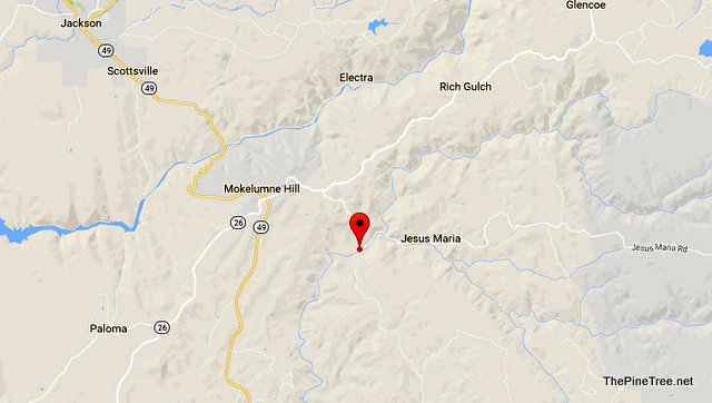

Incident: 00254 Type: Traffic Hazard Location: Jesus Maria Rd / Hawver Rd Loc Desc: Lat/Lon: 38.282774 -120.669762 Close
Detail Information
4:56 PM 4 [4] CASO STILL LL W/ INVLVD WILL SEE IF FIRE IS IN AREA
4:56 PM 3 [3] WATER NOW COMING INTO VEH
4:56 PM 2 [2] TRIED TO DRIVE THRU FLOODED RDWY
4:56 PM 1 [1] 1126X // UNKN TYPE VEH
Incident: 00252 Type: Roadway Flooding Location: Sr12 / Central Hill Rd Loc Desc: WB SR12 JWO Lat/Lon: 38.202006 -120.723010 Close
Detail Information
4:46 PM 3 [3] 1039 1
4:45 PM 2 [2] 1039 CTRANS
4:44 PM 1 [1] WB LANE JWO PASSING LANE
Incident: 00251 Type: Roadway Flooding Location: Sr12 / Toll Bridge Rd Loc Desc: Lat/Lon: 38.206899 -120.710023 Close
Detail Information
4:43 PM 2 [2] 1039 CT
4:43 PM 1 [1] HUGE PUDDLE ON BRIDGE AND JWO
Incident: 00240 Type: Trfc Collision-Unkn Inj Location: Sr4 / Sr207 Loc Desc: SR4 JWO 207 Lat/Lon: 38.482506 -120.019466 Close
Detail Information
4:58 PM 5 [6] [Rotation Request Comment] ***** 1039 SAM BERRI 209-728-3931 *****
4:57 PM 4 [5] 1039 CT
4:56 PM 3 [3] JWO CABBAGE PATCH 1185 FOR FULL SIZE DODG RAM 1500
4:01 PM 2 [2] VAN VS BLK MERZ
4:01 PM 1 [1] 2 VEHS – BLKING EB LNE
Unit Information
4:03 PM 1 Unit Assigned
Incident: 00176 Type: Roadway Flooding Location: Sr49 / Carson Hill Loc Desc: SR49/CARSON HILL Lat/Lon: 38.027778 -120.506667 Close
Detail Information
4:47 PM 6 [14] 12/TOLL BRIDGE RD WB LANE FLOODED
3:45 PM 5 [13] 1039 CALA SO
3:41 PM 4 [11] SIGNS FOR NOW//BUT IF THE CULVERT STAYS BLOCKED IT’S GOING TO KEEP RISING
1:35 PM 3 [4] 1039 CTRANS
1:33 PM 2 [3] PER CASO – ALSO OTHER END OF TOWN NR BONANZA LANE – FLOODING
1:12 PM 1 [1] WATER ACROSS BOTH LNS
Incident: 00387 Type: Traffic Hazard Location: Holtzel Rd / Dogtown Rd Loc Desc: 9800 BLOCK HOLTZEL Lat/Lon: 37.720166 -120.093126 Close
Detail Information
4:08 PM 2 [4] 1039 61-4
4:03 PM 1 [3] **CORR FIRE WILL CALL PGE
Unit Information
4:20 PM 3 Unit Assigned
4:20 PM 2 Unit Enroute
5:00 PM 1 Unit At Scene
Incident: 00153 Type: CLOSURE of a Road Location: Bonds Flat Rd / J59 Loc Desc: Lat/Lon: 37.716677 -120.444400 Close
Detail Information
10:03 AM 1 [1] BONDS FLAT ROAD CLOSED FROM J59 TO SR132
The Latest Collision, Road Hazards, Flooding & Closure List added by admin on
View all posts by admin →