


Arnold, CA…Summer’s first prolonged heatwave is underway through Thursday evening. Natures air conditioner is working at higher elevations as Bear Valley’s, Lake Aline & Pinecrest temps could be up to 26 degrees cooler than Copperopolis, Angels Camp, Valley Springs or Sonora. Arnold & Twain Harte will roll in 10 – 16 degrees cooler. Tonight, Clear. Lows 68 to 76. Prevailing west winds up to 10 mph shifting to the east after midnight. Tuesday, Sunny. Highs 95 to 107. Prevailing northeast winds up to 10 mph shifting to the west in the afternoon. Tuesday Night, Clear. Lows 67 to 75. Prevailing west winds up to 10 mph shifting to the northeast after midnight.
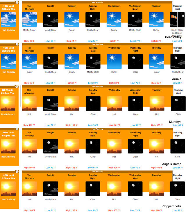
Wednesday
Sunny. Highs 95 to 107. Prevailing northeast winds up to 10 mph shifting to the west in the afternoon.
Wednesday Night
Clear. Lows 69 to 77. Prevailing west winds 5 to 15 mph shifting to the northeast after midnight.
Thursday
Sunny. Highs 96 to 108.
Thursday Night
Clear. Lows 66 to 74.
Friday Through Sunday
Clear. Highs 88 to 103. Lows 62 to 74.
Sunday Night And Monday
Clear. Lows 58 to 66. Highs 84 to 99.
Heat Advisory
URGENT – WEATHER MESSAGE
National Weather Service Sacramento CA
241 PM PDT Mon Jun 19 2017
…Very hot temperatures persist this week across interior
Northern California…
.Very hot temperatures are expected through Thursday. This
extended heat event will increase heat related illnesses for
those exposed to prolonged outdoor heat, especially the elderly,
children, and other sensitive groups.
The heat will gradually subside over the weekend, but triple
digit heat expected through Saturday.
CAZ013-063-064-066>069-210000-
/O.CON.KSTO.HT.Y.0001.000000T0000Z-170623T0300Z/
Shasta Lake Area / Northern Shasta County-
Mountains Southwestern Shasta County to Northern Lake County-
Clear Lake/Southern Lake County-
Northeast Foothills/Sacramento Valley-Motherlode-
Western Plumas County/Lassen Park-
West Slope Northern Sierra Nevada-
Including the cities of Shasta Dam, Alder Springs, Lakeport,
Paradise, Grass Valley, Jackson, Chester, Quincy, and Blue Canyon
241 PM PDT Mon Jun 19 2017
…HEAT ADVISORY REMAINS IN EFFECT UNTIL 8 PM PDT THURSDAY…
* TEMPERATURE…Foothill temperatures well into the 90s to 105
degrees through Thursday. Thermal belt areas in the foothills
only cooling into the mid 70s to lower 80s for nighttime lows.
* IMPACTS…Long outdoor exposure will increase chances for heat
related illness, especially for sensitive groups and people
without access to AC. Heat stress possible for livestock with
limited relief from the heat overnight. Area waterways running
very cold and fast, increasing risk for hypothermia and water
rescues.
PRECAUTIONARY/PREPAREDNESS ACTIONS…
A Heat Advisory means that a period of hot temperatures is
expected. Very hot temperatures can create a situation in which
heat illness is possible. Drink plenty of fluids, stay in an air-
conditioned room, stay out of the sun, and check up on relatives
and neighbors.
Take extra precautions if you work or spend time outside. When
possible, reschedule strenuous activities to the early morning or
evening. Know the signs and symptoms of heat exhaustion and heat
stroke. Wear light weight and loose fitting clothing when
possible and drink plenty of water.
&&
Interact with us via social media
www.facebook.com/nws.sacramento
www.twitter.com/nwssacramento
Heat Advisory Through Thursday…Our Advice…Head For The Hills or Lakes! added by admin on
View all posts by admin →