

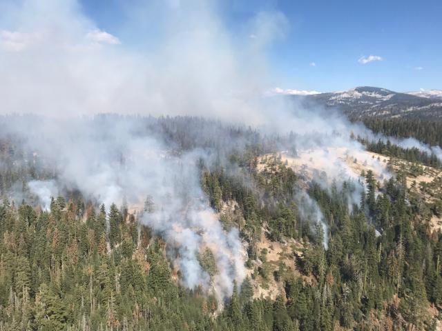
Yosemite, CA…The Empire Fire is being managed for both resource and protection objectives. It is approximately 1 mile south of the Bridalveil Campground east of Alder Creek drainage and west of Bridalveil Creek drainage, burning in Red fir. Fire behavior has been actively flanking and backing with some single and group tree torching. The fire is burning in heavy pockets of dead and down timber, reducing fuels buildup which increases forest resiliency. Projected fire growth is expected in the northeast and southeast flanks.

Finding insurance is a huge problem for homeowners in the Sierra Nevada foothills. Delos is here to help you find insurance for your new home, a lower price for your current home, or help you out of a non-renewal situation. Delos is an independent insurance brokerage that focuses specifically on wildfire and brush areas. We can write any type of insurance: home, auto, umbrella, business and more. Submit a request for a quote through our website, email, or call. Tom Pratt 209-206-3390 tom@getdelos.com www.getdelos.com Article Continues Below
The affected area is in a fire-adapted wilderness. Allowing fires to burn naturally can result in healthier, more diverse ecosystems. Reducing fuels buildup minimizes the potential for future severe fires. Although the current fire may have transient, moderate smoke impacts, more severe fires can cause unhealthy levels of smoke for extended periods, over a much wider area.
Trails are closed from Bridalveil Creek Campground at the second junction with the Ostrander trail and from Westfall Meadow to the Deer Camp junction, along Alder Creek. Bridalveil Creek Campground is closed for fire resource use.
The fire will be visible from the high country and may be seen from multiple viewpoints in the immediate area off Glacier Point Road including Sentinel and Washburn Points. Fire Managers are working with the local Air Quality Districts and will be monitoring smoke impacts to the park and local communities. Community members who are sensitive to smoke may want to close their windows and doors and monitor the air quality links below.
Location: N 37° 38′ 40″ x W 119119119° 37 ° 37° 37′ 6″ at approximately 73at approximately 73 at approximately 73at approximately 73 at approximately 73 at approximately 73 at approximately 73at approximately 73at approximately 73 at approximately 7300 feet elevation00 feet elevation00 feet elevation 00 feet elevation00 feet elevation00 feet elevation 00 feet elevation00 feet elevation00 feet elevation00 feet elevation
Discovery Date: July 31st, 2017
Size: 1450 acres
Cause: Lightning
For additional Information:
Fire Information: Yose_Fire_Info@nps.gov
Yosemite National Park Fire Information website: http://www.nps.gov/yose/blogs/fireinfo.htm
Facebook: Search– Yosemite Fire and Aviation: @YosemiteFire
Twitter: Search @YosemiteFire https://twitter.com/YosemiteFire
Air Quality: https://www.nps.gov/yose/learn/nature/aqmonitoring.htm
Yosemite Area Empire Fire Update August 17th, 1,450 Acres added by News Desk on
View all posts by News Desk →