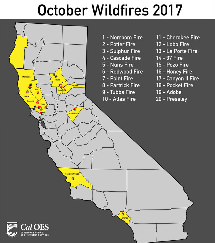
California Statewide Fire Summary Sunday, October 15, 2017. Yesterday, nearly 11,000 firefighters beat back the flames and made good progress towards the containment of now 15 large wildfires across California. 217,566 acres have burned in the current 15 large fires, with an estimated 5,700 structures destroyed. Sadly, the death toll has risen to 40 people. As progress has been made on several fronts, many evacuations have been able to be lifted. As of Sunday morning, nearly 75,000 people remain evacuated.

Finding insurance is a huge problem for homeowners in the Sierra Nevada foothills. Delos is here to help you find insurance for your new home, a lower price for your current home, or help you out of a non-renewal situation. Delos is an independent insurance brokerage that focuses specifically on wildfire and brush areas. We can write any type of insurance: home, auto, umbrella, business and more. Submit a request for a quote through our website, email, or call. Tom Pratt 209-206-3390 tom@getdelos.com www.getdelos.com Article Continues Below
Winds across Northern California have been fairly light this morning and the earlier Red Flag Warnings for the area will be lifted at 8a.m. In Southern California, Red Flag Warnings remain in effect due to gusty winds, low humidity and high fire danger. The winds are likely to continue throughout the day. Residents are urged to be prepared for wildfires now. Learn more by visiting www.ReadyForWildfire.org.
Fires of Interest:
**CAL FIRE Incidents**
CENTRAL LNU COMPLEX (4 fires)
- In unified command with Santa Rosa Fire Department & Sonoma County Sheriff
- CAL FIRE Incident Management Team assigned
- 20 civilian fatalities
Tubbs Fire, Sonoma and Napa Counties (more info…)
Between Calistoga and Santa Rosa
- 35,470 acres, 60% contained
- Significant number of structures destroyed
Pocket Fire, Sonoma County (more info…)
North of Geyserville
- 11,246 acres, 25% contained
Nuns Fire, Sonoma County (more info…)
East of Hwy 12 from east Santa Rosa to east of Sonoma
- 47,106 acres, 25% contained
Oakmont Fire, Sonoma County
Near Oakmont
- 550 acres, 15% contained
SOUTHERN LNU COMPLEX (2 fires)
- CAL FIRE Incident Management Team assigned
Atlas Fire, Napa & Solano Counties (more info…)
South of Lake Berryessa and northeast of Napa
- 51,057 acres, 56% contained
- 6 civilian fatalities
- Significant structures destroyed
MENDOCINO-LAKE COMPLEX (2 fires)
- CAL FIRE Incident Management Team assigned
Redwood Valley, Mendocino County (more info…)
North of Hwy 20 in Potter Valley and Redwood Valley
- 35,000 acres, 35% contained
- 8 civilian fatalities
- Significant structures destroyed
Sulphur Fire, Lake County (more info…)
Clearlake Oaks
- 2,207 acres, 70% contained
WIND COMPLEX (4 fires)
- CAL FIRE Incident Management Team assigned
Cascade Fire, Yuba County (more info…)
Loma Rica area
- 9,989 acres, 87% contained
- 4 civilian fatalities
- Significant structure destroyed
Lobo Fire, Nevada County (more info…)
Rough and Ready area
- 821 acres, 96% contained
- Multiple structures destroyed
LaPorte Fire, Butte County (more info…)
Bangor area
- 6,151 acres, 80% contained
OTHER FIRES
Cherokee Fire, Butte County (more info…)
North of Oroville
- 8,417 acres, 90% contained
Honey Fire, Butte County (more info…)
Southwest of Paradise
- 150 acres, 90% contained
Long Fire, Lake County
Hwy 20 & Long Valley Rd, 5 east of Clearlake Oaks
- 100 acres, 25% contained
Silver Fire, Fresno County FINAL
Northwest of Squaw Valley
- 58 acres, 100% contained
Lynch Fire, San Luis Obispo County FINAL
North of Lake Nacimiento
- 73 acres, 100% contained
Loma Fire, San Diego County FINAL
Camp Pendleton
- 80 acres, 100% contained
**Unified Command Incidents**
Canyon 2 Fire, Orange County (more info…)
Hwy 91 & Gypsum Canyon Rd, Anaheim City
- 9,217 acres, 75% contained
- Unified command with CAL FIRE, Orange County, Anaheim and City of Orange
**Federal Incidents**
River Fire, Trinity County NEW
Community of Mad River
US Forest Service – Six Rivers National Forest
- 85 acres, 25% contained


