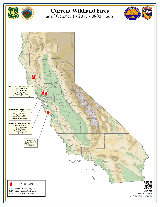
Sacramento, CA…Over 10,000 firefighters continue making progress on 9 large wildfires burning across California. Yesterday, cooler temperatures and higher humidity aided firefighters in their efforts and allowed for additional evacuations to be lifted. Just over 15,000 people remain evacuated by the fires. As the damage assessment continues latest estimates now put the destruction at an estimated 6,900 structures. Overall weather conditions in Northern California will remain cooler as a light storm system moves into the region bringing rain in some areas in the late hours and overnight. A Red Flag Warning is in effect to the Tahoe Basin and the Eastern Sierra for gusty winds and low humidity. Gusts up to 50mph are possible. Since the start of the October Fire Siege on Sunday, October 8, CAL FIRE has responded to 250 new wildfires. At the peak of the wildfires there were 21 major wildfires that, in total, have burned over 245,000 acres, 11,000 firefighters battled the destructive fires that at one time forced 100,000 to evacuate, destroyed an estimated 6,900 structures, and sadly, took the lives of 42 people.

Finding insurance is a huge problem for homeowners in the Sierra Nevada foothills. Delos is here to help you find insurance for your new home, a lower price for your current home, or help you out of a non-renewal situation. Delos is an independent insurance brokerage that focuses specifically on wildfire and brush areas. We can write any type of insurance: home, auto, umbrella, business and more. Submit a request for a quote through our website, email, or call. Tom Pratt 209-206-3390 tom@getdelos.com www.getdelos.com Article Continues Below
Residents returning home are urged to be cautious as hazardous conditions may remain. Learn more tips on how to return home after a wildfire at www.fire.ca.gov.
Fires of Interest:
**CAL FIRE Incidents**
CENTRAL LNU COMPLEX (3 fires)
- In unified command with Santa Rosa Fire Department & Sonoma County Sheriff
- CAL FIRE Incident Management Team assigned
Tubbs Fire, Sonoma and Napa Counties (more info…)
Between Calistoga and Santa Rosa
- 36,432 acres, 92% contained
- Significant number of structures destroyed
- 22 civilian fatalities & 1 private water tender operator
Pocket Fire, Sonoma County (more info…)
North of Geyserville
- 16,552 acres, 73% contained
Nuns Fire, Sonoma County (more info…)
East of Hwy 12 from east Santa Rosa to east of Sonoma
- 54,423 acres, 82% contained
- 1 civilian fatality & 1 private water tender operator in Napa County
SOUTHERN LNU COMPLEX (1 fire)
- CAL FIRE Incident Management Team assigned
Atlas Fire, Napa & Solano Counties (more info…)
South of Lake Berryessa and northeast of Napa
- 51,624 acres, 83% contained
- 6 civilian fatalities
- Significant structures destroyed
MENDOCINO-LAKE COMPLEX (2 fires)
- CAL FIRE Incident Management Team assigned
Redwood Valley, Mendocino County (more info…)
North of Hwy 20 in Potter Valley and Redwood Valley
- 36,523 acres, 85% contained
- 8 civilian fatalities
- Significant structures destroyed
Sulphur Fire, Lake County (more info…)
Clearlake Oaks
- 2,207 acres, 96% contained
WIND COMPLEX FINAL
- 398 structures destroyed
Cascade Fire, Yuba County (more info…) FINAL
Loma Rica area
- 9,989 acres, 100% contained
- 4 civilian fatalities
- Significant structure destroyed
Lobo Fire, Nevada County (more info…) FINAL
Rough and Ready area
- 821 acres, 100% contained
- Multiple structures destroyed
LaPorte Fire, Butte County (more info…) FINAL
Bangor area
- 6,151 acres, 100% contained
OTHER FIRES
Fallon Fire, Alameda County FINAL
Fallon Road, 3 miles east of Dublin
- 116 acres, 100% contained
**Unified Command Incidents**
Bear Fire, Santa Cruz County (more info…)
Bear Creek Canyon Road, northeast of Boulder Creek
- 320 acres, 30% contained
**Federal Incidents**
Wilson Fire, Los Angeles County (more info…)
Mount Wilson, Mount Wilson Observatory
- 50 acres, 45% contained
Buffalo Fire, San Diego County (more info…)
Camp Pendleton
- 1,088 acres, 80% contained


