


Bear Valley, CA…From the National Weather Service for the West Slope Northern Sierra Nevada. Today Mostly sunny in the morning, then partly cloudy with a slight chance of rain in the afternoon. Highs 42 to 57 higher elevations…52 to 60 lower elevations. Prevailing southeast winds up to 10 mph shifting to the southwest in the afternoon. Tonight Mostly cloudy. At lower elevations, a chance of rain in the evening, then rain likely after midnight. At higher elevations, a chance of rain in the evening, then rain and snow likely after midnight. Colder. Lows 26 to 41 higher elevations… 39 to 47 lower elevations. Little or no snow accumulation. Snow level above 8000 feet decreasing to 7500 feet after midnight. Prevailing south winds up to 10 mph.
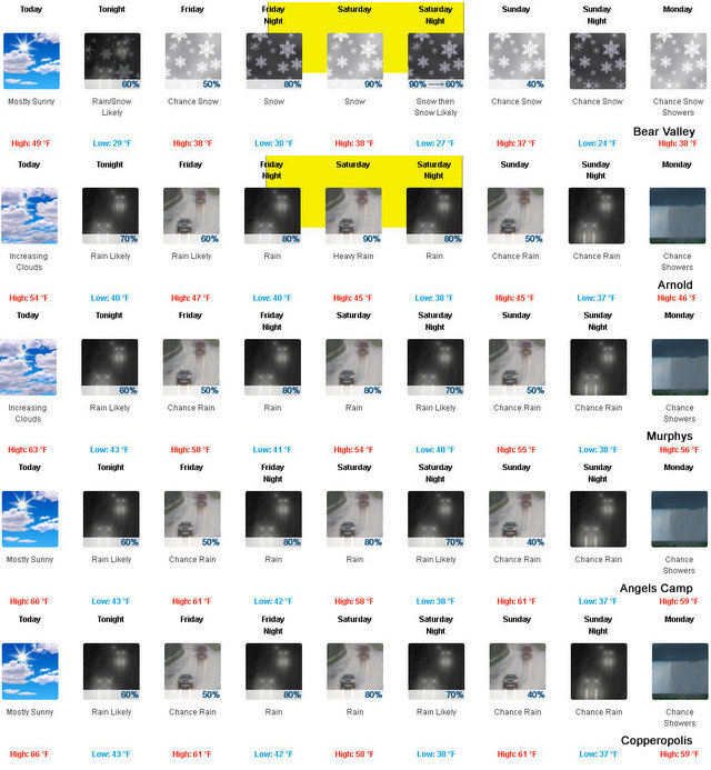
Friday Rain at lower elevations…and rain and snow likely at higher elevations. Highs 34 to 49 higher elevations…46 to 54 lower elevations. No snow accumulation lower elevations…up to 2 inches higher elevations. Snow level 7000 feet. Prevailing south winds 5 to 15 mph with gusts to around 30 mph.
Friday Night Heavy rain and snow. Lows 25 to 40 higher elevations…38 to 45 lower elevations. No snow accumulation lower elevations…3 to 5 inches higher elevations. Snow level 7000 feet. Prevailing south winds 5 to 15 mph with gusts to around 30 mph…except southwest 15 to 30 mph over ridges.
Saturday Heavy rain and snow. Highs 32 to 47 higher elevations…43 to 51 lower elevations. No snow accumulation lower elevations…2 to 7 inches higher elevations. Snow level 6000 feet. Prevailing south winds 10 to 20 mph.
Saturday Night Rain and snow likely. Colder. Light snow accumulations possible. Lows 25 to 40.
Sunday Cloudy with a chance of rain and snow. Highs 34 to 49.
Sunday Night Mostly cloudy with a chance of rain and snow. Lows 24 to 39.
Monday Mostly cloudy with a chance of rain and snow showers. Highs 35 to 50.
Monday Night Partly cloudy with a slight chance of rain and snow showers. Lows 24 to 39.
Tuesday Partly cloudy. Not as cool. Highs 40 to 55.
Tuesday Night Partly cloudy with a slight chance of rain showers. Lows 28 to 43.
Wednesday Mostly cloudy with a chance of rain and snow showers. Not as cool. Highs 43 to 58.
Winter Storm Watch
URGENT – WINTER WEATHER MESSAGE
National Weather Service Sacramento CA
508 AM PDT Thu Nov 2 2017
…SIGNIFICANT MOUNTAIN SNOW FRIDAY EVENING INTO THE WEEKEND…
.A significant early season storm is forecast to bring snow and
wind to the mountains of interior Northern California Friday and
into the weekend. A couple of feet of snow are possible above
6000 feet by Sunday. Motorists planning travel into the mountains
during this time frame should be prepared for winter driving
conditions.
CAZ069-030000-
/O.CON.KSTO.WS.A.0001.171104T0600Z-171105T1200Z/
West Slope Northern Sierra Nevada-
508 AM PDT Thu Nov 2 2017
…WINTER STORM WATCH REMAINS IN EFFECT FROM FRIDAY EVENING
THROUGH LATE SATURDAY NIGHT ABOVE 6000 FEET…
* WHAT…Heavy wet snow possible. Plan on difficult travel
conditions. Total wet snow accumulations of 5 to 8 inches, with
localized amounts up to 16 inches, are possible.
* WHERE…West Slope Northern Sierra Nevada.
* WHEN…From Friday evening through late Saturday night.
* SNOW LEVELS…Around 6500 feet Friday evening dropping to around
5500 feet by Saturday evening.
* WIND…Gusts 20 to 30 mph up to 40 mph
* ADDITIONAL DETAILS…Significant reductions in visibility are
possible as wind and snow combine.
PRECAUTIONARY/PREPAREDNESS ACTIONS…
A Winter Storm Watch means there is potential for significant
snow, that may impact travel. Continue to monitor the latest
forecasts.
$$
As Much as Two Feet of High Country Snow Heading Our Way added by admin on
View all posts by admin →