


Arnold, CA…Winter has arrived along the West Slope Northern Sierra Nevada according to the National Weather Service. Today Rain at lower elevations…and rain and snow at higher elevations. Highs 35 to 50 higher elevations…44 to 59 lower elevations. No snow accumulation lower elevations…3 to 5 inches higher elevations. Snow level 6500 feet increasing to above 8000 feet in the afternoon. Prevailing southeast winds 10 to 20 mph, gusts up to 55 mph in the afternoon. Over ridges…prevailing southwest winds 15 to 30 mph increasing to 25 to 45 mph in the afternoon with gusts up to 65 mph. Tonight At lower elevations, heavy rain. At higher elevations, heavy rain and heavy snow in the evening, then heavy rain after midnight. Windy. Lows 29 to 43 higher elevations…41 to 47 lower elevations. Snow accumulation 2 to 4 inches. Snow level above 8000 feet. Prevailing south winds 15 to 30 mph with gusts to around 60 mph…except southwest 30 to 50 mph with gusts to around 75 mph over ridges.
Thursday At lower elevations, heavy rain in the morning, then heavy rain showers in the afternoon. At higher elevations, heavy rain and heavy snow. Windy. Highs 34 to 48 higher elevations… 43 to 51 lower elevations. No snow accumulation lower elevations…4 to 10 inches higher elevations. Snow level above 8000 feet. Prevailing south winds 15 to 25 mph with gusts to around 50 mph… Except southwest 30 to 45 mph with gusts to around 65 mph over ridges.
Thursday Night Rain and snow showers in the evening, then a chance of rain and snow showers after midnight. Colder. Lows 19 to 31 higher elevations…31 to 37 lower elevations. No snow accumulation lower elevations…2 to 4 inches higher elevations. Snow level 5500 feet. Prevailing southwest winds 10 to 20 mph with gusts to around 40 mph…except southwest 20 to 35 mph with gusts to around 50 mph over ridges.
Friday Partly cloudy in the morning then clearing. Highs 33 to 48 higher elevations…43 to 53 lower elevations. Prevailing west winds up to 10 mph.
Friday Night Mostly clear. Lows 21 to 36.
Saturday Mostly sunny. Not as cool. Highs 42 to 57.
Saturday Night Mostly clear. Lows 26 to 41.
SundayMostly cloudy. Highs 43 to 58.
Sunday NightRain and snow likely. Lows 30 to 45.
MondayRain likely. Highs 43 to 55.
Monday NightMostly cloudy with a chance of rain. Lows 32 to 47.
Tuesday Mostly cloudy with a slight chance of rain showers. Highs 45 to 59.
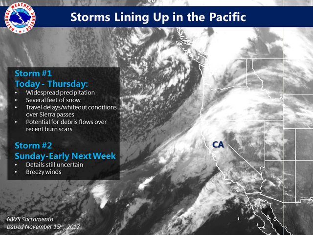
…HEAVY MOUNTAIN SNOW TODAY THROUGH THURSDAY NIGHT…
.Pacific storm will bring periods of moderate to heavy snow above
6000 feet along with strong gusty winds. The heaviest snow is
expected this afternoon Thursday evening. Motorists planning
travel into the mountains of Western Plumas county and the Sierra
Nevada during this time frame should be prepared for hazardous
winter driving conditions.
CAZ069-152300-
/O.CON.KSTO.WS.W.0002.171115T1800Z-171117T1200Z/
West Slope Northern Sierra Nevada-
240 AM PST Wed Nov 15 2017
…WINTER STORM WARNING REMAINS IN EFFECT FROM 10 AM THIS MORNING
TO 4 AM PST FRIDAY ABOVE 6000 FEET…
* WHAT…Heavy wet snow and strong wind expected with near zero
visibility at times. Travel will be extremely difficult with
significant delays and chain controls possible. Damage to trees
and power lines as well as local rock and debris flows may
occur. Total wet snow accumulations of 8 to 15 inches expected,
with localized amounts of 2 to 4 feet possible at higher
elevations. Snow levels will generally be near or above pass
levels through tonight, then lower below passes Thursday.
* WHERE…West Slopes of Northern Sierra Nevada including
Interstate 80 over Donner Pass, Highway 50 over Echo Summit and
Highway 88 over Carson Pass.
* WHEN…10 AM today to 4 AM Friday. Light snow begins this
morning becoming heavy this afternoon through Thursday evening.
* ADDITIONAL DETAILS…Be prepared for significant reductions in
visibility at times. Southwest wind gusts over 65 mph are
possible at the higher peaks.
PRECAUTIONARY/PREPAREDNESS ACTIONS…
A Winter Storm Warning for heavy wet snow and strong wind means
there will be snow covered roads and limited visibilities. Travel
is not recommended while the warning is in effect. If you must
travel, keep an extra flashlight, food, water, and blankets in
your vehicle in case of an emergency. The latest road conditions
for the state you are in can be obtained by dialing 5 1 1.
$$
Winter is Here, at Least for the Next Few Days. added by admin on
View all posts by admin →