


Bear Valley, CA…Winter returns as a colder system moves through our area. For the rest Of Today At lower elevations, a slight chance of rain late in the morning, then heavy rain in the afternoon. At higher elevations, rain early in the afternoon. Rain and snow late in the afternoon. Windy. Highs 44 to 59 higher elevations…51 to 65 lower elevations. No snow accumulation. Snow level above 8000 feet in the afternoon. Prevailing south winds 15 to 30 mph with gusts to around 55 mph…except southwest 30 to 50 mph with gusts to around 65 mph over ridges.
Tonight At lower elevations, heavy rain in the evening, then heavy rain showers after midnight. At higher elevations, rain and snow in the evening, then snow showers and heavy rain showers after midnight. Breezy, colder. Lows 24 to 38 higher elevations… 35 to 43 lower elevations. No snow accumulation lower elevations…1 to 7 inches higher elevations. Snow level above 8000 feet decreasing to 6500 feet after midnight. Prevailing southwest winds 10 to 25 mph with gusts to around 50 mph. Over ridges, prevailing south winds 30 to 45 mph shifting to the southwest 25 to 35 mph after midnight. Gusts up to 60 mph over ridges.
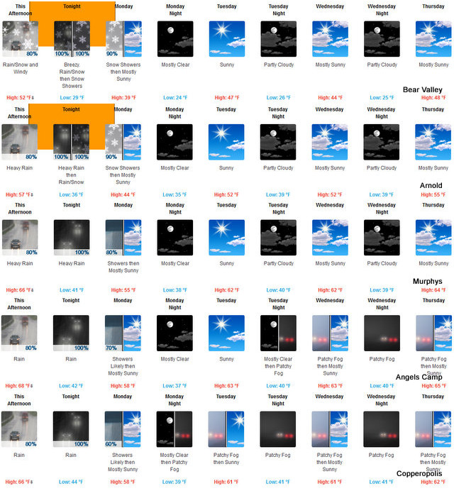
Monday Rain and snow showers in the morning. Highs 32 to 47 higher elevations…45 to 51 lower elevations. No snow accumulation lower elevations…1 to 4 inches higher elevations. Snow level 4500 feet in the morning. Prevailing southwest winds up to 10 mph in the morning becoming light. Gusts up to 25 mph.
Monday Night Mostly clear. Lows 21 to 36 higher elevations… 34 to 41 lower elevations. Prevailing east winds up to 15 mph.
Tuesday Mostly sunny. Not as cool. Highs 40 to 55 higher elevations…50 to 58 lower elevations. Prevailing east winds up to 10 mph shifting to the southwest in the afternoon.
Tuesday Night Mostly clear. Lows 27 to 42.
Wednesday Mostly sunny. Highs 41 to 56.
Wednesday Night Partly cloudy. Lows 26 to 41.
Thursday Mostly sunny. Not as cool. Highs 45 to 60.
Thursday Night And Friday Partly cloudy. Lows 28 to 43. Highs 45 to 60.
Friday Night Mostly cloudy with a slight chance of rain. Lows 29 to 44.
Saturday Mostly cloudy with a chance of rain and snow. Highs 35 to 50.
Winter Weather Advisory
URGENT – WINTER WEATHER MESSAGE
National Weather Service Sacramento CA
833 AM PST Sun Nov 26 2017
CAZ068-069-271800-
/O.CON.KSTO.WW.Y.0019.171127T0000Z-171127T1800Z/
Western Plumas County/Lassen Park-
West Slope Northern Sierra Nevada-
833 AM PST Sun Nov 26 2017
…WINTER WEATHER ADVISORY REMAINS IN EFFECT FROM 4 PM THIS
AFTERNOON TO 10 AM PST MONDAY ABOVE 7000 FEET…
* WHAT…Wet snow and strong winds. Plan on difficult travel
conditions and possible damage to trees and power lines. Total
snow accumulations of 4 to 8 inches, with localized amounts up
to 12 inches, above 7000 feet. A few inches down to 5000 feet.
Wind gusts over 50 mph possible.
* WHERE…Western Plumas County/Lassen Park and West Slope
Northern Sierra Nevada including Interstate 80 over Donner Pass,
Highway 50 over Echo Summit and Highway 88 over Carson Pass.
* WHEN…4 PM today to 10 AM Monday. Heaviest between 8 PM tonight
and 4 AM Monday.
* ADDITIONAL DETAILS…Snow levels may fluctuate near pass level
this afternoon and evening before dropping below pass level
tonight. Be prepared for reduced visibilities at times.
PRECAUTIONARY/PREPAREDNESS ACTIONS…
A Winter Weather Advisory for snow means periods of snow will
cause primarily travel difficulties. Be prepared for snow covered
roads and limited visibilities, and use caution while driving. The
latest road conditions for the state you are calling from can be
obtained by calling 5 1 1.
$$
CEO
Winter Returns as Colder System Rolls in Tonight added by admin on
View all posts by admin →