


Arnold, CA…The National Weather Service Forecast for the West Slope Northern Sierra Nevada is as follows: Today Rain at lower elevations…and rain and snow at higher elevations. Highs 36 to 51 higher elevations…48 to 54 lower elevations. No snow accumulation lower elevations…2 to 4 inches higher elevations. Snow level 7000 feet increasing to above 8000 feet in the afternoon. Prevailing south winds 5 to 15 mph with gusts to around 30 mph.
Tonight Rain at lower elevations…and rain and snow at higher elevations. Lows 29 to 44 higher elevations…42 to 50 lower elevations. No snow accumulation lower elevations…1 to 7 inches higher elevations. Snow level above 8000 feet. Prevailing south winds 10 to 20 mph.
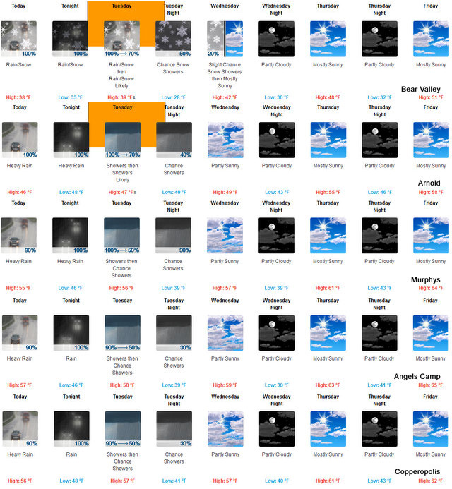
Tuesday Rain showers at lower elevations…and rain and snow showers at higher elevations. Highs 34 to 49 higher elevations… 47 to 53 lower elevations. No snow accumulation lower elevations…3 to 5 inches higher elevations. Snow level 7500 feet. Prevailing southeast winds up to 10 mph shifting to the southwest in the afternoon.
Tuesday Night Mostly cloudy with a chance of rain and snow showers. Colder. Lows 25 to 40 higher elevations…37 to 45 lower elevations. No snow accumulation lower elevations…up to 1 inch higher elevations. Snow level 6500 feet. Prevailing southwest winds up to 10 mph.
Wednesday Mostly cloudy with a slight chance of rain and snow showers. Highs 36 to 51 higher elevations…47 to 55 lower elevations. Snow level 6000 feet. Prevailing southwest winds up to 10 mph.
Wednesday Night Partly cloudy. Lows 29 to 44.
Thursday Partly cloudy with a slight chance of rain. Not as cool. Highs 45 to 60.
Thursday Night Partly cloudy. Lows 31 to 46.
Friday Through Sunday Mostly clear. Highs 48 to 63. Lows 32 to 47.
Its Beginning to Look A Lot Like Winter added by admin on
View all posts by admin →